St. Ellen: Difference between revisions
No edit summary |
No edit summary |
||
| Line 9: | Line 9: | ||
|image_alt = | |image_alt = | ||
|image_caption = | |image_caption = | ||
|image_flag = | |image_flag = Territorial_Flag_St_Ellen.png | ||
|flag_alt = | |flag_alt = Flag | ||
|image_seal = | |image_seal = | ||
|seal_alt = | |seal_alt = | ||
Revision as of 21:41, 12 July 2021
This article is incomplete because it is pending further input from participants, or it is a work-in-progress by one author. Please comment on this article's talk page to share your input, comments and questions. Note: To contribute to this article, you may need to seek help from the author(s) of this page. |
St. Ellen | |
|---|---|
| Motto: | |
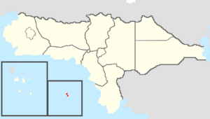
 Map of Rizealand with St. Ellen in red | |
| Country | |
| Before annexation | Colony of St. Ellen |
| Capital (and largest city) | Ellensport |
| Formation | December 7, 1773 |
| Government | |
| • Governor | Patrick Kennedy (TNC-NRP) |
| • Legislature | St. Ellen Legislative Assembly |
| • Federal representation | Councilors
|
| Area | |
| • Total | 1,128.96 km2 (435.89 sq mi) |
| Population (2021) | |
| • Total | 58,108 |
| • Density | 51.47/km2 (133.3/sq mi) |
| Time zone | UTC+8 (Vehemens) |
| Abbreviation | EL |
| ISO 3166 code | RZ-EL |
| Website | www |
St. Ellen is a dependent overseas territory of Rizealand located on the island of St. Ellen in the center of the Vehemens Ocean. St. Ellen has a total area of 1,128.96 square kilometers, making it the smallest territory and political division of Rizealand. St. Ellen also has a population of 58,108, making it the least populous territory and political entity in Rizealand. St. Ellen's capital and largest city is Ellensport, and it is the only territory and one of only two political divisions to be non-contiguous with the rest of Rizealand.
Etymology
St. Ellen is named after its predecessor, the Colony of St. Ellen, which was founded by the Caldians in 1601 and named for St. Ellen, the patron Sotirian saint of Caldia.
