User:Lyonsland/sandbox: Difference between revisions
Jump to navigation
Jump to search
(Blanked the page) Tag: Blanking |
No edit summary |
||
| Line 1: | Line 1: | ||
{{Infobox settlement | |||
|name = Riis | |||
|native_name = ''Rijs'' | |||
|native_name_lang = | |||
|settlement_type = Municipality | |||
|image_skyline = Gemeentehuis_Eindhout.jpg | |||
|imagesize = | |||
|image_alt = | |||
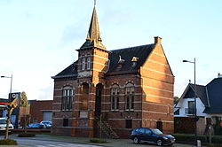
|image_caption = Riis Gemeentehûs (town hall) | |||
|image_flag = Etten-Leur_vlag.svg | |||
|flag_alt = | |||
|image_seal = | |||
|seal_alt = | |||
|image_shield = | |||
|shield_alt = | |||
|etymology = | |||
|nickname = | |||
|motto = | |||
|image_map = {{Location map|Hennehouwe | |||
|alt = | |||
|lat_deg = 38.3 | |||
|lon_deg = 28.1 | |||
|position = left | |||
|label = Riis | |||
|caption = | |||
|width = 300 | |||
}} | |||
|map_alt = | |||
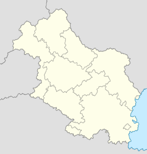
|map_caption = Location in Hennehouwe | |||
|pushpin_map = | |||
|pushpin_map_alt = | |||
|pushpin_map_caption = | |||
|pushpin_label_position = | |||
|coordinates = <!-- {{coord|latitude|longitude|type:city|display=inline,title}} --> | |||
|coor_pinpoint = | |||
|coordinates_footnotes = | |||
|subdivision_type = Country | |||
|subdivision_name = [[Hennehouwe]] | |||
|subdivision_type1 = Region | |||
|subdivision_name1 = [[Lower Stegeren]] | |||
|subdivision_type2 = County | |||
|subdivision_name2 = Grensland | |||
|subdivision_type3 = | |||
|subdivision_name3 = | |||
|established_title = | |||
|established_date = | |||
|founder = | |||
|seat_type = | |||
|seat = | |||
|government_footnotes = | |||
|government_type = | |||
|governing_body = {{wp|Municipal council}} | |||
|leader_party = [[National People's Party (Hennehouwe)|NVP]] | |||
|leader_title = Mayor | |||
|leader_name = Marina Hoekstra | |||
|leader_title1 = | |||
|leader_name1 = | |||
|leader_title2 = | |||
|leader_name2 = | |||
|leader_title3 = | |||
|leader_name3 = | |||
|leader_title4 = | |||
|leader_name4 = | |||
|unit_pref = Metric | |||
<!-- ALL fields with measurements have automatic unit conversion --> | |||
<!-- for references: use <ref> tags --> | |||
|area_footnotes = | |||
|area_urban_footnotes = <!-- <ref> </ref> --> | |||
|area_rural_footnotes = <!-- <ref> </ref> --> | |||
|area_metro_footnotes = <!-- <ref> </ref> --> | |||
|area_note = | |||
|area_water_percent = | |||
|area_rank = | |||
|area_blank1_title = | |||
|area_blank2_title = | |||
<!-- square kilometers --> | |||
|area_total_km2 = 84.81 | |||
|area_land_km2 = 84.35 | |||
|area_water_km2 = 0.46 | |||
|area_urban_km2 = | |||
|area_rural_km2 = | |||
|area_metro_km2 = | |||
|area_blank1_km2 = | |||
|area_blank2_km2 = | |||
|length_km = | |||
|width_km = | |||
|dimensions_footnotes = | |||
|elevation_footnotes = | |||
|elevation_m = 33 | |||
|population_footnotes = | |||
|population_as_of = 2018 census | |||
|population_total = 7,641 | |||
|population_density_km2 = auto | |||
|population_note = | |||
|population_demonym = | |||
|timezone1 = | |||
|utc_offset1 = | |||
|timezone1_DST = | |||
|utc_offset1_DST = | |||
|postal_code_type = {{wp|Postcode}} | |||
|postal_code = NH31 | |||
|area_code_type = {{wp|Area code}} | |||
|area_code = 047 | |||
|area_codes = <!-- for multiple area codes --> | |||
|iso_code = | |||
|website = {{URL|riis.he}} | |||
|module = | |||
|footnotes = | |||
}} | |||
'''Riis''' ({{wp|Dutch language|Hennish}}: ''Rijs'', also referred to as '''East-Riis''' or '''Oost-Rijs'''), is a [[Hennehouwe#Administrative divisions|municipality]] in [[Hennehouwe]], located in the region of [[Lower Stegeren]]. The municipality is located on the border between Hennehouwe and [[Estmere]], sharing a complicated borderline with {{wp|exclave|exclaves}} that make up the majority of the Estmerish town [[Rees]], which themselves contain second-order exclaves of Riis. The municipality had a population of 7,641 at the time of the 2018 census. | |||
In addition to the complicated border, Riis is also famous for hosting the Rock'nRiis festival along with its Estmerish sister town, with the festival main stage traditionally straddling the border of the two countries. | |||
Revision as of 17:57, 19 January 2022
Riis
Rijs | |
|---|---|
Municipality | |
 Riis Gemeentehûs (town hall) | |
Location in Hennehouwe | |
| Country | Hennehouwe |
| Region | Lower Stegeren |
| County | Grensland |
| Government | |
| • Body | Municipal council |
| • Mayor | Marina Hoekstra (NVP) |
| Area | |
| • Total | 84.81 km2 (32.75 sq mi) |
| • Land | 84.35 km2 (32.57 sq mi) |
| • Water | 0.46 km2 (0.18 sq mi) |
| Elevation | 33 m (108 ft) |
| Population (2018 census) | |
| • Total | 7,641 |
| • Density | 90/km2 (230/sq mi) |
| Postcode | NH31 |
| Area code | 047 |
| Website | riis |
Riis (Hennish: Rijs, also referred to as East-Riis or Oost-Rijs), is a municipality in Hennehouwe, located in the region of Lower Stegeren. The municipality is located on the border between Hennehouwe and Estmere, sharing a complicated borderline with exclaves that make up the majority of the Estmerish town Rees, which themselves contain second-order exclaves of Riis. The municipality had a population of 7,641 at the time of the 2018 census.
In addition to the complicated border, Riis is also famous for hosting the Rock'nRiis festival along with its Estmerish sister town, with the festival main stage traditionally straddling the border of the two countries.
