Free City of Randstadt: Difference between revisions
mNo edit summary |
mNo edit summary |
||
| Line 48: | Line 48: | ||
|religion_ref = <!--(for any ref/s to associate with religion data)--> | |religion_ref = <!--(for any ref/s to associate with religion data)--> | ||
|demonym = <!--Term/s describing those associated with the country/territory (e.g. "Belgian" for the country Belgium)-->Randstadter | |demonym = <!--Term/s describing those associated with the country/territory (e.g. "Belgian" for the country Belgium)-->Randstadter | ||
|government_type = | |government_type = [[wikipedia:Unitary state|Unitary]] [[wikipedia:Parliamentary republic|parliamentary republic]] | ||
|leader_title1 = <!--(for a country, usually the head of state's (wikilinked) title, e.g. "President", "Monarch")-->[[Bürgermeister of Randstadt|Bürgermeister]] | |leader_title1 = <!--(for a country, usually the head of state's (wikilinked) title, e.g. "President", "Monarch")-->[[Bürgermeister of Randstadt|Bürgermeister]] | ||
|leader_name1 = [[Andreas von Innenteil]] | |leader_name1 = [[Andreas von Innenteil]] | ||
Revision as of 02:32, 6 January 2025
Free City of Randstadt Freistadt Randstadt (Alemannisch) | |
|---|---|
 | |
| Capital | Randstadt |
| Official languages | Alemannisch |
| Demonym(s) | Randstadter |
| Government | Unitary parliamentary republic |
| Andreas von Innenteil | |
| Viktor Holzer | |
| Legislature | Staatsräte |
| Meisterrat | |
| Gemeinderat | |
| Constituent State of Dolchland | |
• Settlement founded | 842 |
| 1534 | |
• Granted Free charter | 1577 |
| Area | |
• | 17.51 km2 (6.76 sq mi) |
| Population | |
• 2021 estimate | 24,230 |
• Density | 1,383.92/km2 (3,584.3/sq mi) |
 | |
| |
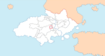
Randstadt, officially the Free City of Randstadt (Alemannisch: Freistadt Randstadt) is a semi-independent constituent state of Dolchland. Randstadt is located between the Panedonian exclave of Gloschlick, the Landgraviate of Witternen and Gmunenhochwald.
Randstadt has never been a particularly important city within Dolchland. Settlement of what was then called Emmerichswald began in 842, and the village in the area traded in wood, fur and textiles. Little attention was paid to the settlement, so much so that after the ($WAR) of ($DATE) to 1305, the subsequent peace treaty completely missed out the village of Emmerichswald. Local folk tale tells of the guildmasters of the village attempting to pay taxes to each of the three bordering states, but being refused each time, until finally deciding to pay taxes directly to the Emperor. Regardless of the truth of the matter, the area passed outside of all three bordering states' spheres of influence for so long that in 1577, the city was granted Free Charter as the Free City of Randstadt.
Randstadt is the smallest constituent state of Dolchland both by area and by population, with an area of and a population of 24,230. The state, despite the area being mostly comprised of the city that shares its name, is decidedly rural, with few social services, low education and a small GDP.
History
Flag and coat of arms
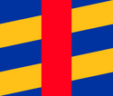
Randstadt has a coat of arms that has served as its main symbol since the granting of Imperial Free Charter in 1577. The arms consist of a party bendy sinister in argent and or, defaced with a pale gules. The state's flag consists of the same symbol as a banner of arms, in a ratio of 7:6. There is no distinction between the civil, state and government flag of Randstadt. The blue and gold represents the nearby Rost and the land around it, while the red vertical line represents the border regions of which Randstadt comprise.
Geography
Randstadt is situated around the Greater Blutflusstal region of Dolchland, and is bordered to the north by Gmunenhochwald, to the east by the Panedonian exclave of Gloschlick, and to the west by the Landgraviate of Witternen. The western border is marked by the Rost, a tributary of the Blutfluss. Randstadt's location on the Rost is a key reason why it is a state of Dolchland to this day - the Treaty of Compenburg defined the border of Witternen as the land west of the Rost, while specifying that the former Witternish villages of ($VILLAGE), ($VILLAGE) and ($VILLAGE) on the eastern side of the Rost belonged to the Duchy of Gloschlick. The omission of Randstadt, while understandable given its size, is rather a quirk of its geographical history.
Randstadt is located in the foothills of the ($MOUNTAINS/$HILLS). There is little variation between its lowest and highest points.
Given that the exclave of Gloschlick is not contiguous with Panedonia, Randstadt has the interesting position of being doubly landlocked while also bordering a state with a coastline. Randstadt is by far the smallest state of Dolchland by area.
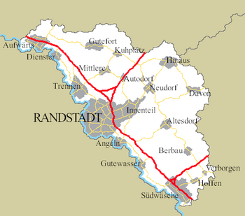
The territory of Randstadt is divided into 15 municipalities. Most of these municipalities surround a single town or village. These are further divided into three regions - the municipalities of Aufwärts, Gutefort, Mittlere, Kuhplatz and Hinaus comprise the Nordregion; the municipalities of Davon, Altesdorf, Flussdörfer, Berbau-Verborgen and Südwäsche-Hoffen comprise the Südregion; and the municipalities of Dienster, Trennen, Oberhaupt, Niederhaupt and Innenteil comprise the Hauptregion.
Demographics
As for population, Randstadt is Dolchland's smallest constituent state, with 24,230 people calling the country home. Of these, most are over sixth-generation locals, with the remainder largely being immigrants from other states of Dolchland. Randstadters have an average life expectancy at birth of 76.0 years, subdividing as male: 74.4 years, and female: 77.6 years. The infant mortality in Randstadt is 13.8 deaths per 1000 live births, according to 2020 estimates.
Urbanisation
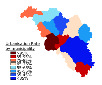
Given the small overall population and area of Randstadt, the rate of urbanisation is defined as the percentage of the population inhabiting a settlement of over 100 people. This measurement is significantly smaller than most countries', but accurately reflects Randstadt's situation. With this definition, 75.87% of the population lives in urban areas, while the remaining 24.13% lives in sparse settlements across the remainder of Randstadt's land. There are 20 defined settlements that have more than 100 people.
The City of Randstadt is technically a conurbation comprising the municipalities of Niederhaupt, Oberhaupt and Innenteil, the first, second and fourth largest towns in Randstadt. Innenteil is also considered a suburb of Randstadt, and is often counted as separate, whereas both Niederhaupt and Oberhaupt are simply considered political subdivisions of Randstadt. The total population of the City of Randstadt is 8,178. The Randstadt Census Bureau considers any settlement with above 1,000 inhabitants a town, while those between 100 and under 1,000 inhabitants are villages. Outside of the City of Randstadt, there are three towns. The largest town outside of Randstadt-proper is Südwäsche, with a population of 2,226. The other two towns are Trennen, with a population of 1,251, and Aufwärts with a population of 1,237. The smallest village recognised as a distinct settlement is Verborgen, with a population of 102. Verborgen formerly possessed a larger population, but it had been in decline during the early- to mid-20th century. The latter part of the 20th century saw its population begin to recover, and by the 2010 census, it had a population sizeable enough to consider it a village. It has remained largely stagnant since then.
Village occupancy has increased somewhat due to the development of automotives and the building of main roads in Randstadt. There are three major roads in Randstadt, most of which are simply continuations of larger roads in Randstadt's bordering states, but they are somewhat new developments. The towns of Südwäsche and Aufwärts have developed sizeably thanks in part to their placements on the southern and northern borders respectively, and smaller villages have sprung up thanks to road usage. The village of Autodorf emerged around a petrol station and road garage, and now has a population of 192, most of whom work in the larger petrol station complex in some form.
| Rank | Municipality | Pop. | Rank | Municipality | Pop. | ||||
|---|---|---|---|---|---|---|---|---|---|
| 1 | Niederhaupt | Niederhaupt | 3,290 | 11 | Altesdorf | Altesdorf | 462 | ||
| 2 | Oberhaupt | Oberhaupt | 2,674 | 12 | Davon | Davon | 424 | ||
| 3 | Südwäsche | Südwäsche-Hoffen | 2,226 | 13 | Dienster | Dienster | 358 | ||
| 4 | Innenteil | Innenteil | 2,204 | 14 | Gutewasser | Flussdörfer | 344 | ||
| 5 | Trennen | Trennen | 1,251 | 15 | Mittlere | Mittlere | 336 | ||
| 6 | Aufwärts | Aufwärts | 1,237 | 16 | Berbau | Berbau-Verborgen | 291 | ||
| 7 | Hinaus | Hinaus | 879 | 17 | Hoffen | Südwäsche-Hoffen | 211 | ||
| 8 | Gutefort | Gutefort | 690 | 18 | Kuhplatz | Kuhplatz | 206 | ||
| 9 | Angeln | Flussdörfer | 486 | 19 | Autodorf | Kuhplatz | 192 | ||
| 10 | Neudorf | Hinaus | 477 | 20 | Verborgen | Berbau-Verborgen | 102 | ||
Languages
The official language of Randstadt is Alemannisch, and is spoken by the entire populace. Randstadt's linguistic identity is incredibly homogeneous.
Religion
(Christianity of some sort)
Politics
Randstadt is a republic, with a Bürgermeister as the head of state, and a bicameral elected parliament of representatives that enact laws. The Constitution of Randstadt was adopted in 1846, and remains unchanged since. The legislature of Randstadt is the Staatsräte of Randstadt, and is bicameral.
Executive authority within Randstadt is vested in the position of Bürgermeister, with the upper house, the Meisterrat, selecting the Bürgermeister from among them. Positions of Meister within the Meisterrat are elected by an archaic system involving the major guilds of Randstadt selecting one Meister each. There is no theoretical limit on how many terms either a Meister or the Bürgermeister may serve, meaning that many serve for long periods of time or until death.
The remaining legislative authority is vested in the Gemeinderat, whose leader, the First Minister of the Gemeinderat, is selected by the body of ministers. While the Meisterrat can have a theoretically unlimited number of members, by how many guilds are accepted within the Staatsräte, the Gemeinderat is limited to two for each municipality. Since the administrative re-allocation of municipalities imposed by the 1846 constitution, there are therefore 30 members of the Gemeinderat. The First Minister, usually the leader of the party with the largest share of the votes, selects a speaker to act as the moderator of discussion and debate within the Gemeinderat.
Suffrage in Randstadt differs depending on which elections take place. For elections to the Meisterrat, an individual must have a profession that applies to one of the guilds of the Meisterrat or, since 1846, a company or individual may opt to pay membership dues to one of the guilds and they and their employees may vote within their elections. As such, an individual may have anywhere up to a total of three votes within Meisterrat elections, though most citizens have one or two. This leads to a complex chain of custody for election results, as ballots remain anonymous, and so it is fairly easy to falsify certain results, and individuals with no employment may not vote. For elections in the Gemeinderat, suffrage is universal for individuals above the age of 18. Until 1846, suffrage was based on land ownership, with a household of landowners being permitted to vote. After the passing of the Constitution, this was changed to every man over the age of 18. In 1945, women over the age of 25 were permitted to vote for the first time, and in 2003, the suffrage for women became the same as it was for men - over the age of 18.
Municipalities
Prior to 1846, the lower administrative divisions were Kantone, of which there were five. The 1846 constitution established municipalities, basing them around the built-up regions of Randstadt, mainly villages and towns. The number and size of these municipalities has not changed since they were established, despite the founding of new villages since their establishment which would in their own rights be able to create new municipalities.
The borders of these municipalities generally follow roads, farm and natural boundaries. The constitution refers to the Municipal Charter, a document created before the constitution which defined in precise detail what the borders of each municipality would entail. Given the continued presence of each of these old markers into the present day, hikers and trailwalkers set themselves the task following the borders of any particular municipality by reading the Municipal Charter and following its instructions. Where a border intersects a road, however, the border is clearly marked.
Each municipality has its own coat of arms and flag, many of which are displayed prominently around each municipality. Many municipalities offer particular privileges to members of certain guilds, such as hunting, farming or land use.
Culture
As a result of its small size, even among some of the smallest states of Dolchland, Randstadt has always been affected strongly by the bordering cultural influences, most notably those of Panedonia and Blutflusstal.
The largest museum in Randstadt is the Gildenmuseum, a history and art museum operated by the Meisterrat.
The Randstadt Staatsbibliothek is the sole civil library in the whole of Randstadt, and has has legal deposit for all books published in the country. The only other library is the Randstadt Rechtsbibliothek, which contains a compendium of all laws and legal publications within the state.
The most famous historical sights are Gutefort, Südwäsche bridge, the Grand Guildhall of Randstadt and Davon Seminar.
On Randstadt's national holiday, Alle Gildentag, or "all guilds' day", the entire population is invited to the Grand Guildhall to partake in celebrations. Many people attend the events, and the streets are usually decorated with the flags of the various guilds and the Randstadt national flag.
Economy
Transport
There are roughly ($DISTANCE) km of paved roadway in Randstadt. This is divided into three major roads and numerous state roads. Minor roads are generally unpaved, and are usually not noted on maps due to being private, unsafe or otherwise not generally used.
There is a single railway running from northwest to southeast through Randstadt, and three railway stations along it - Aufwärts, Südwäsche and Randstadt Hauptbahnhof. The train service is fairly irregular, and only stops through Randstadt on its way elsewhere on certain sparse occasions.
Randstadt Autobus is the state-owned transport company of Randstadt, and operates numerous services throughout the country. It operates six major inter-municipal bus routes in two directions, as well as two inner-town bus routes for the towns of Südwäsche and Aufwärts and four cross-border shuttles. Randstadt Autobus operates a fleet of 23 buses, five shuttlebuses and two charter-coaches.
Randstadt has no airport, nor an airfield. The nearest airport is ($PLACE).
Education
The literacy rate in Randstadt is 83.1%. There are no centres of higher education in Randstadt, with students of higher education institutions having to travel outside of the state to learn.
There are two public secondary schools in Randstadt, as well as a private secondary school and a seminary. These are;
- Randstadtisches Großes Gymnasium in Niederhaupt
- Gymnasium Südwäsche in Südwäsche-Hoffen
- Privatgymnasium Neudorf in Hinaus
- Davon Seminar in Davon
There are also four public primary schools in Randstadt, as well as two private primary schools. These are;
- Randstadtisches Großes Grundesschule in Niederhaupt (adjoined to the Randstadtisches Großes Gymnasium)
- Landesschule Oberhaupt in Oberhaupt
- Grundesschule Südwäsche in Südwäsche-Hoffen (adjoined to the Gymnasium Südwäsche)
- Landesschule Dienster in Dienster
- Privatgrundesschule Mittlere in Mittlere
- Innenteil Privatgrundesschule in Innenteil


