User:Rhava: Difference between revisions
Jump to navigation
Jump to search
No edit summary |
No edit summary |
||
| Line 41: | Line 41: | ||
| topo = | | topo = | ||
| type = | | type = | ||
| age = | | age = 82 million | ||
| geology = | | geology = | ||
| volcanic_arc = | | volcanic_arc = | ||
| Line 65: | Line 65: | ||
==Climate== | ==Climate== | ||
==Culture Groups== | ==Culture Groups== | ||
==Tourism== | |||
<gallery> | |||
Mount Emei pic 1.jpg | Mount Thibomimak (Phukhao Thibomimak) | |||
Ho Heak 3.jpg | Mount Loei | |||
Ho Heak 4.jpg | Mount Tarodpai's Summit | |||
Ho Heak 6.jpg | Mount Phudony | |||
شعيب_جو_بجبال_أجـــا_-_panoramio.jpg | Mount Hinsi Bua | |||
</gallery> | |||
[[Category:Mahana]] | [[Category:Mahana]] | ||
Revision as of 20:16, 4 February 2022
| Ho Heak Mountains | |
|---|---|
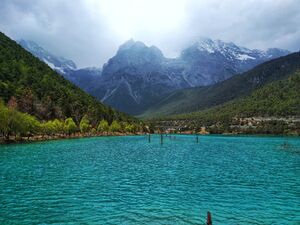
 The Ho Heak Mountains from Chaohong Lake | |
| Highest point | |
| Peak | Mount Tarodpai |
| Elevation | 5,526 m (18,130 ft) |
| Naming | |
| Etymology | "Where the Mountain Meets the Moon" |
| Geography | |
| Location | Rhava |
| Geology | |
| Age of rock | 82 million |
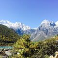
The Ho Heak Mountain Range, or Ho Heak (Sichaeng: ລະດັບພູເຂົາຫໍເຫຼັກ) are a large mountain range in Rhava that borders the Camdong Plateau in Rhava.
The Ho Heak Mountains are home to some of Eurth's tallest mountains, including one of the tallest, Mount Tarodpai (ພູເຂົາຕະຫຼອດໄປ) which is 5,526 meters tall.


