Kainuinoa: Difference between revisions
Jump to navigation
Jump to search
(Created page with "{{Region_icon_Ajax}} {{Infobox country |conventional_long_name = Council of Kainuinoa |native_name = ʻAha o Kainuinoa {{collapsible list |titlestyle = b...") |
No edit summary |
||
| Line 39: | Line 39: | ||
|alt_map = | |alt_map = | ||
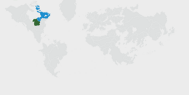
|map_caption = Location of Kainuinoa on Earth. | |map_caption = Location of Kainuinoa on Earth. | ||
|image_map2 = | |image_map2 = Kainuinoa Political Map.png | ||
|map2_width = 275px | |map2_width = 275px | ||
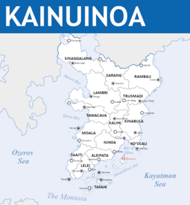
|alt_map2 = Political Map of Kainuinoa | |alt_map2 = Political Map of Kainuinoa | ||
Revision as of 23:26, 15 February 2023
Council of Kainuinoa ʻAha o Kainuinoa 11 official names
| |||||||||||||||||||
|---|---|---|---|---|---|---|---|---|---|---|---|---|---|---|---|---|---|---|---|
|
Flag | |||||||||||||||||||
| Motto: ᨙ ᨊᨕᨗᨗ ᨓᨕᨒᨙ ᨊᨚ ᨚᨘᨀᨚᨘ᨞ ᨗ ᨀᨘᨘ ᨄᨚᨊᨚ ᨕᨚᨒᨙ ᨄᨕᨘ᨟ E naʻi wale nō ʻoukou, i kuʻu pono ʻaʻole pau "Prevail with my righteous deeds, for they are not yet finished." | |||||||||||||||||||
| Anthem: ᨖᨙ ᨆᨙᨒᨙ ᨒᨕᨖᨘᨗ ᨄᨚᨊᨚ He Mele Lāhui Pono "Song of the Righteous People" | |||||||||||||||||||
 Location of Kainuinoa on Earth. | |||||||||||||||||||
 Political Map of Kainuinoa | |||||||||||||||||||
| Capital | Wahiuliuli | ||||||||||||||||||
| Largest city | Johol | ||||||||||||||||||
| Official languages | Tokohanareo | ||||||||||||||||||
| Recognised regional languages | |||||||||||||||||||
| Ethnic groups (2020) | List of ethnicities | ||||||||||||||||||
| Religion | List of religions
| ||||||||||||||||||
| Demonym(s) | Kainuinoan Kainuinoans (plural) | ||||||||||||||||||
| Government | Theocratic federated noocratic oligarchy | ||||||||||||||||||
• Guide of the Faithful | Kumu Ihupani | ||||||||||||||||||
| Legislature | National Consultative Assembly | ||||||||||||||||||
| Holy Council of the Righteous | |||||||||||||||||||
| Deliberative Council | |||||||||||||||||||
| Unification | |||||||||||||||||||
• Independence from Arthurista | November 13th, 1845 | ||||||||||||||||||
• Formation of the Holy Council | August 8th, 1852 | ||||||||||||||||||
• Safa'atoa Declaration | 1853 | ||||||||||||||||||
• Poi Reforms | April 28th, 1893 | ||||||||||||||||||
| Area | |||||||||||||||||||
• Total area | 134,864 km2 (52,071 sq mi) | ||||||||||||||||||
| Population | |||||||||||||||||||
• 2020 census | 38,000,000 | ||||||||||||||||||
• Density | [convert: invalid number] | ||||||||||||||||||
| GDP (nominal) | 2020 estimate | ||||||||||||||||||
• Total | $674,317,894,800 | ||||||||||||||||||
• Per capita | $15758 | ||||||||||||||||||
| Gini (2020) | low | ||||||||||||||||||
| HDI (2015) | very high | ||||||||||||||||||
| Currency | Kainuinoan Tālā (₮) | ||||||||||||||||||
| Time zone | UTC +6 | ||||||||||||||||||
| Date format | dd/mm/yyyy | ||||||||||||||||||
| Driving side | left | ||||||||||||||||||
| Calling code | +37 | ||||||||||||||||||
| Internet TLD | .kn | ||||||||||||||||||
Kainuinoa officially The Council of Kainuinoa is a Theocratic Noocracy in Southern Ochran between the Ozeros and Kayatman seas. It is bordered to the West by Ankat, to the North by [REDCACTED], and shares a maritime border with Pulau Keramat to the South along the Monusiya strait.
Cite error: <ref> tags exist for a group named "lower-alpha", but no corresponding <references group="lower-alpha"/> tag was found
