Districts of Arimathea: Difference between revisions
Jump to navigation
Jump to search
(Created page with "{{Infobox subdivision type | name= Districts of Armathea<br>Malkharzhez Arimathe'ka <small>(Trellinese)</small> | map= File:Map of distr...") |
m (1 revision imported) |
(No difference)
| |
Revision as of 18:47, 28 January 2019
| Districts of Armathea Malkharzhez Arimathe'ka (Trellinese) | |
|---|---|
 | |
| Location | Arimathea |
| Number | 11 |
| Areas | 3,338 km2 (Kahazarqa) – 19,497 km2 (Lannek) |
| Government | Districtual government |
| Subdivisions | Municipalities |
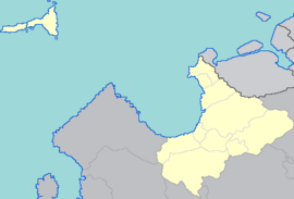
Districts in Arimathea are the country's top-level administrative subdivision. They were established in 1927 by the Parliamentary Act for Local Governance, which created the current eleven subdivisions in approximately their current boundaries. The district governments are responsible for the administration and upkeep of social and emergency services, including education and housing, as well as the maintenance of non-motorway roads and commuter rail networks.
| District | |||
|---|---|---|---|
| Erhothi | Parsig | ||
| Eth Bandig | Khalet | ||
| Kahazarqa | Ka'azar | 3,338 | |
| Lannek | Forlath | 19,497 | |
| Lemata | Dargai | ||
| Malahér | Maktal | ||
| Orez'g | Temolen | ||
| Qohza Siriga | Qoredri | ||
| Serëforz | Arimathea | ||
| Tythika | Tythim | ||
| Vedalkaeka | Vedalkae |