Tayar: Difference between revisions
Jump to navigation
Jump to search
No edit summary |
No edit summary |
||
| Line 17: | Line 17: | ||
|largest_city = Lazhyan | |largest_city = Lazhyan | ||
|official_languages = [[Tayari language|Tayari]] | |official_languages = [[Tayari language|Tayari]] | ||
|regional_languages = | |regional_languages = {{wp|Portuguese language|Lavish}}, {{wp|Polish language|Osevan}} | ||
|ethnic_groups = X | |ethnic_groups = X | ||
|religion = X | |religion = X | ||
Revision as of 19:45, 9 February 2020
This article is incomplete because it is pending further input from participants, or it is a work-in-progress by one author. Please comment on this article's talk page to share your input, comments and questions. Note: To contribute to this article, you may need to seek help from the author(s) of this page. |
Tayari Republic Gomhûrî Tayârê (Tayari) | |
|---|---|
| Motto: "X" "For Our People" | |
| Anthem: "X" "Banner of the Fatherland" | |
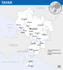
| Location of Tayar (green) with X and foreign Tayari controlled territories (light green) Location of Tayar (green) with X and foreign Tayari controlled territories (light green) | |
 19XX border (internationally recognized) | |
| Capital and largest city | Lazhyan |
| Official languages | Tayari |
| Recognised regional languages | Lavish, Osevan |
| Ethnic groups | X |
| Religion | X |
| Demonym(s) | Tayari |
| Government | Unitary semi-presidential republic |
• President | Mahmoud Wezwar |
• Minister-General | Bushar Aboun |
• Speaker of Parliament | Salim Leuge |
| Legislature | National Council |
| Formation | |
• X | X |
• X | X |
• X | X |
• X | X |
• X | X |
• X | X |
• X | X |
| Area | |
• Total | 37,749 km2 (14,575 sq mi) |
• Water (%) | 4.8% |
| Population | |
• 2018 estimate | 9,735,800 |
• 2017 census | 9,416,393 |
| GDP (PPP) | 2019 estimate |
• Total | $165.4 billion (16th) |
• Per capita | $16,992 |
| GDP (nominal) | 2018 estimate |
• Total | $71.6 billion (17th) |
• Per capita | $7,350 |
| HDI (2017) | 0.753 high |
| Currency | Herai (२) (HR) |
| Time zone | UTC+4 |
| Date format | MM/DD/YYYY |
| Driving side | right |
| Calling code | +838 |
| Internet TLD | .ty |
Tayar (/təˌjɑː(ɹ)/; Tayari: Tayâr [tɑˈjɑːr]), officially the Tayari Republic (Tayari: Gomhûrî Tayârê [gɔmhuːriː tɑˈjɑːrɛː]), is a country in X. Located in X, it is bounded by Oseva to the north, the Larija Gulf to the west, Similia to the south-west, and the Sarvan Gulf to the south.

