Alexandria: Difference between revisions
Jump to navigation
Jump to search
mNo edit summary |
mNo edit summary |
||
| Line 71: | Line 71: | ||
|area_rank = | |area_rank = | ||
|area = <!--Major area size (in [[Template:convert]] either km2 or sqmi first)--> | |area = <!--Major area size (in [[Template:convert]] either km2 or sqmi first)--> | ||
|area_km2 = | |area_km2 = 122,554.88 | ||
|area_sq_mi = <!--Area in square mi (requires area_km2)--> | |area_sq_mi = <!--Area in square mi (requires area_km2)--> | ||
|area_footnote = <!--Optional footnote for area--> | |area_footnote = <!--Optional footnote for area--> | ||
Revision as of 17:29, 22 March 2020
Union of Alexandria Union d'Alexandrie (Gaullican) | |
|---|---|
|
Flag | |
| Motto: Justice, stabilité, démocratie Justice, Stability, Democracy | |
| Anthem: Hymne de la nation | |
 | |
| Capital and | Lafayette |
| Official languages | Gaullican |
| Ethnic groups (2017) | 82% Euclean 7% Indigenous 4% Bahians 7% Other |
| Demonym(s) | Alexandrian |
| Government | Federal Semi-Presidential Republic (De-jure) Federal Dominant-Party Republic (De-facto |
• President | Thérèse Besnard |
• Prime Minister | Achille Couturier |
| Legislature | National Forum |
| Independence from Gaullica | |
• Independence from Gaullica | 1935 |
• Aviyonne Declaration | 1962 |
• Current Constitution | 1980 |
| Area | |
• | 122,554.88 km2 (47,318.70 sq mi) |
| Population | |
• 2019 estimate | 832,000 |
• 2010 census | 793,000 |
| GDP (nominal) | estimate |
• Total | 11.9 Billion |
• Per capita | 14.3 Thousand |
| Gini (2019) | 39 medium |
| HDI | 0.768 high |
| Driving side | right |
| Calling code | +5 |
| Internet TLD | .AX |
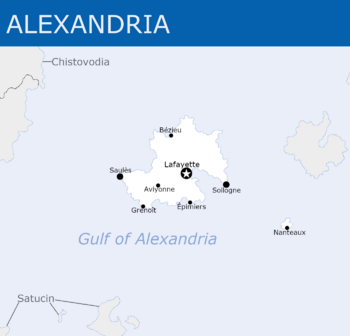
Union of Alexandria (Gaullican: Union d'Alexandrie), commonly referred to as Alexandria (Gaullican: Alexandrie) is a sovereign state located in Asteria Superior in the Gulf of Alexandria. The country shares sea borders with X and Satucin. The country is divided into X States with the cities of Lafayette and Soliogne being their own States. The island of Chotoise is Alexandria's only State not on the main island.
