River Andoma: Difference between revisions
Jump to navigation
Jump to search
No edit summary |
No edit summary |
||
| Line 8: | Line 8: | ||
<!---------------------- IMAGE--> | <!---------------------- IMAGE--> | ||
| image = File:The Delta of the River Andoma .jpg | | image = File:The Delta of the River Andoma .jpg | ||
| image_size = | | image_size = 150px | ||
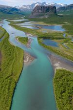
| image_caption = | | image_caption = River Andoma in January | ||
| image_alt = | | image_alt = | ||
<!---------------------- MAPS --> | <!---------------------- MAPS --> | ||
| Line 45: | Line 45: | ||
| discharge1_max = | | discharge1_max = | ||
<!---------------------- BASIN FEATURES --> | <!---------------------- BASIN FEATURES --> | ||
| source1 = | | source1 = Lake Jürgen | ||
| source1_location = | | source1_location = | ||
| source1_coordinates= <!-- {{Coord|...}} --> | | source1_coordinates= <!-- {{Coord|...}} --> | ||
| source1_elevation = | | source1_elevation = 1,520 m (4,986 ft) | ||
| mouth = [[Bay of Asta]] | | mouth = [[Bay of Asta]] | ||
| mouth_location = | | mouth_location = | ||
Latest revision as of 17:55, 5 March 2021
| River Andoma Götaish: Andœma | |
|---|---|
 River Andoma in January | |
 | |
| Location | |
| Country(s) | Blechingia, Lyonheimer |
| Proveince(s) | Swabia |
| Citys | Diepholz, Kempten |
| Physical characteristics | |
| Source | Lake Jürgen |
| - elevation | 1,520 m (4,986 ft) |
| Mouth | Bay of Asta |
- elevation | Sea Leavel (0 m) |