Gmunenhochwald: Difference between revisions
No edit summary |
No edit summary |
||
| Line 24: | Line 24: | ||
|alt_map = <!--alt text for map--> | |alt_map = <!--alt text for map--> | ||
|map_caption = <!--Caption to place below map--> | |map_caption = <!--Caption to place below map--> | ||
|image_map2 = <!--Another map, if required-->[[GmunenhochwaldCities1.png|250px]] | |image_map2 = <!--Another map, if required-->[[File:GmunenhochwaldCities1.png|250px]] | ||
|alt_map2 = <!--alt text for second map--> | |alt_map2 = <!--alt text for second map--> | ||
|map_caption2 = <!--Caption to place below second map-->Map of Gmunenhochwalden | |map_caption2 = <!--Caption to place below second map-->Map of Gmunenhochwalden | ||
Revision as of 22:19, 17 November 2021
Raugraviate of Gmunenhochwald Raugrafschaft auf Gmunenhochwald (Alemannisch) | |
|---|---|
|
Flag | |
 | |
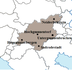
 Map of Gmunenhochwalden | |
| Location | Gmunenhochwald within Dolchland. |
| Capital | Untergmunenbrucken |
| Official languages | Alemannisch |
| Demonym(s) | Gmunenhochwalder |
| Government | |
• Raugrave | Ernst Klemens VI |
| Legislature | Raugrafstag |
| Hirtenrat | |
| Schäferrat | |
| Constituent State of Dolchland | |
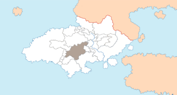
Gmunenhochwald, officially the Raugraviate of Gmunenhochwald (Alemannisch: Raugrafschaft auf Gmunenhochwald), is a semi-independent constituent state of Dolchland, in south-eastern Argis. It is located at almost the geographic centre of the country, between the two mountain ranges of $$$ and $$$. It borders the states of Greater Vethringen to the north, the Duchy of Gloschlick (an exclave of Panedonia) and Witternen to east, the southern part of Panedonia to the south-east, Macklenover and Märzwald to the south and $$$ and $$$ to the west. Gmunenhochwald is a landlocked nation and it has no direct route to the coast. The Raugraviate has a population of $$$, which is mainly rural, is concentrated along the large valley between the mountains, although the majority of the population still lives amongst the valleys, upland fields and forests of the mountains themselves. The river Gmune, which is fed by tributaries from the mountains, runs through the central valley and down through the country, forming a broad fertile floodplain in the east of the nation where it exits into Witternen. There are very few urban areas of any real size and most of these are clustered along the Gmune. The total area of the Raugraviate is $$$. The official language is Alemannisch, athough there are numerous different dialects spoken, some of them with very small geographic spreads, sometimes of only an isolated valley.
The Raugraviate is a unitary parliamentary constitutional monarchy, with the power of the Raugrave defined by the consitution, the $$$. The Raugrave does retain significant powers, however, with the ability to dismiss the government at will, as well as to define laws as they see fit. In practice, however, this is limited by the often personal relationship between the monarch and their government, as well as years of tradition and protocol. The current Raugrave is Ernst Klemens VI of the House of Hochgmunentorf, who has ruled his state since 1957. The capital and most populous city, Untergmunenbrucken, is in the south-east of the country, towards the Witternen border. It is the economic and cultural centre of the state and it has a population of $$$. The other large cities are Neiderbekstein in the north east, Sudrodestadt in the south, Hagenunterbergen in the west and Hochgmunentorf, which is also the seat of the House of Hochgmunentorf.
Gmunenhochwald has seen many thousands of years of human habitation. The Dolchic peoples arrived in the Gmune Valley by 2000BCE. The south of Gmunenhochwald was a key battleground during the War of the Habstrian Succession, as the valley of the Gmune formed a major trade and transportation route across southern Dolchland. A force holding any one of the fortified cities of Untergmunenbrucken, Hochgmunentorf and Hagenunterbergen could close the valley to the opposing side, or at least force them into a costly siege.
