Kamany: Difference between revisions
No edit summary |
|||
| Line 31: | Line 31: | ||
|sovereignty_note = | |sovereignty_note = | ||
|established_event1 = Treaty of Kama | |established_event1 = Treaty of Kama | ||
|established_date1 = 14 January | |established_date1 = 14 January 1824 | ||
|established_event2 = | |established_event2 = | ||
|established_date2 = | |established_date2 = | ||
Latest revision as of 09:00, 31 December 2021
The Federal Republic of Kamany Kamnia Kamnijk | |
|---|---|
| Motto: Dum spiro spero | |
| Anthem: Renoviato | |
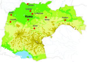
 Main cities and relief of Kamany | |
| File:Location kamany.jpg Kamany (red) located in Persa (continent | |
| Capital and largest city | Kama |
| Official languages | Ladino, Dutch, Polish |
| Demonym(s) | Kamanian |
| Government | Federal parliamentary republic |
| Alesandro Vunilo | |
| Linn Ambux | |
| Legislature | S 2020 |
| Senate | |
| Chamber of Representatives | |
| Alliance | |
• Treaty of Kama | 14 January 1824 |
| Area | |
• Total | 186,927 km2 (72,173 sq mi) |
| Population | |
• 2020 estimate | 22, 347, 113 |
• Density | 120/km2 (310.8/sq mi) |
| GDP (nominal) | 2020 estimate |
• Total | 646,000,000,000 |
• Per capita | 31,209 |
| Currency | Kamanian Pound (KKL) |
| Time zone | UTC +1 |
| Date format | dd-mm-yyyy |
| Driving side | right |
| Calling code | +40 |
| Internet TLD | |
Kamany [kamani], officially the Republic of Kamany is a landlocked country located in central Persa. It borders France to its west, Bade to its northwest, Ernaf and Luxemburg to its north, Korterzag and Vrdinska to its northeast, Ruthenia to its east, Slovenia to its southeast, Bosnia to its south and the Latin Republic to its southwest. Kamany is home to 21,8 million people, of whom 4,3 million live in the region of Kama, its capital. With an area of 186,927 square kilometres Kamany is not considered as a large country.
History
See Also: History of Kamany
Geography and climate
Kamany is located in the centre of Persa and has no access to the sea.The terrain is distributed roughly equally between mountains, hills, and plains. The Balkanic Mountains dominate the south of the country and surround the Lake Montenegro where is located the border with Bosnia. The northwestern part of the country consists of alluvial plains, the north of hills and Galicia is separated from the rest of the country by a short range of mountains, the Penins.
Kamany is home to 5 terrestial ecoregions: the Flaa Basin mixed forests, the Montenegro deciduous forests, the Balkanic conifer and mixed forests, the Penins mixed forests, the Galicia broadleaf forests.
Politics
Federal state
Kamany is a parliamentary federal republic with a multi-party system. The head of state is the President of the Federation and has far-reaching ceremonial obligations but also the right and duty to act politically and is the commander in-chief of the army. The president is elected for five years by a special federal convention composed by members of the federal parliament and local officials.
The executive authority of Kamany is the federal government, composed by eight secretaries and headed by the first secretary of the government. The federal government is led by the first party at the lower house of the parliament and representative of its political structure. The legislative authority is held by a bicameral parliament. The lower house is called the Federal House of Representatives and is composed by 150 members. These 150 representatives are elected in a system of proportional representation and cardinal voting in which voters allow points (out of 10) to candidating lists. Elections take place every five years. The upper house is called the Federal Senate and is composed by 64 members. Each province sends two senators elected by local officials.
The judicial system is independent and based on civil law. The Federal Supreme Court is the court of last resort.
Each region has its own executive, legislative and judicial bodies according to its own constitution.
Political tendencies, parties and elections
The Kamanian federal political system, and particularly proportional cardinal voting, tends to a multi-polarisation of political life. Therefore political parties are obliged to form large coalitions to coexist and govern. The political landscape of the country experienced two milestones since 1977: a bipolarisation of political parties during the 1980s around liberals and social-democrats, since mid-2000s a multi-polarisation of political life around the four blocks of democrats, liberals, ecologists and ephemeral big tent parties.
See also: Kamanian political parties
Constituent entities
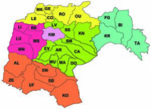
Kamany is constituted by 6 regions and 32 provinces. These entities were enacted through the Kamanian Federalisation Law of 1982. Each region has its own constitution and largely autonomous in regard to its organisation.
Provinces are divided into municipalities. There exists three types: 4 Free Cities (Kama, Genoa, Kanoj and Krakow), which have a large degree of autonomy and a proper constitution and are divided in districts, 76 Cities ruled by a local council and thousands of Communes.
| Coat of arms | Region (local name) | Population (2020) | Pop density | Average monthly income (EUR) | capital city | Area (Km²) |
|---|---|---|---|---|---|---|
| Region of Kama (Regio Kama) | 4,317,442 | 820 | 2550 | Kama | 5268 | |
| Region of Caroz | 4,261,083 | 93 | 1861 | Kanoj | 45,892 | |
| Campina (Kampina) | 2,592,876 | 117 | 1538 | Luanda | 22,216 | |
| O'Sur | 2,634,584 | 50 | 1219 | Zemun | 53,116 | |
 |
Brandebao | 5,121,881 | 208 | 2399 | Genoa | 24,660 |
| Galicia (Galicja) | 3,419,247 | 96 | 1939 | Krakow | 35,775 | |
 |
Kamany | 22,347,113 | 120 | 2011 | Kama | 186,927 |
Demography
The total fertility rate (TFR) in 2019 was estimated at 1.65 children born/woman, which is below the replacement rate of 2.1. The Kamanian population has then an average age of 39 years. Life expectancy was estimated in 2017 at 80 years (75 years for males and 83 for females). The Kamanian population slightly increases at a rate of 0.33% per year and reached 22,347,113 in 2020.


