Yoloten: Difference between revisions
No edit summary |
No edit summary |
||
| Line 70: | Line 70: | ||
|calling_code = [[+918]] | |calling_code = [[+918]] | ||
}} | }} | ||
'''The Yoloten''' ({{wp|Mongol_language|Ukilen}}: Yolotyen; {{wp|Kazakh_language|Majgar}} Yoloten) officially the '''People's Republic of The Yoloten''' ({{wp|Mongol_language|Ukilen}}:Bügd Nairamdakh Yolotyen Ard Uls; {{wp|Kazakh_language|Majgar}} Yoloten Xalıq Respwblïkası) is a {{wp|partially recognised state}} in [[Southeast Coius|Southeastern Coius]] especially the [[Great Steppe]], recognised by most countries as part of [[Hacyinia]], which views the region as a rebellious territory. It borders [[Dezevau]] to the north, [[Lavana]] to the East, and Hacyinia to the south and west. | |||
==Government== | ==Government== | ||
The Yoloten is governed by the Provisional Administrative and Military Front of the Yoloten (PAMFY). Much of the leadership of PAMFY subscribes to the [[Equalism|Equalist]] school of socialist thought. | |||
===Recognition=== | ===Recognition=== | ||
* {{flagicon|Dezevau}} [[Dezevau]] recognised the Yoloten on 26 August 1992. | * {{flagicon|Dezevau}} [[Dezevau]] recognised the Yoloten on 26 August 1992. | ||
Revision as of 22:54, 11 October 2022
This article is incomplete because it is pending further input from participants, or it is a work-in-progress by one author. Please comment on this article's talk page to share your input, comments and questions. Note: To contribute to this article, you may need to seek help from the author(s) of this page. |
People's Republic of the Yoloten Bügd Nairamdakh Yolotyen Ard Uls Yoloten Xalıq Respwblïkası | |
|---|---|
| Motto: "Fart" "Fart" | |
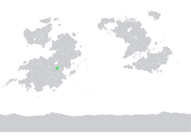
 Location of the Yoloten on Kylaris in light green | |
| Capital | XXXXX |
| Largest city | Capital |
| Recognised national languages | Ukilen, Majgars |
| Ethnic groups | Ukilen XX%
Majgars XX% Male XX% !Azerbaijanis XX% Ziban XX% Other XX% |
| Religion | Badi XX% Irreligion XX% |
| Demonym(s) | Yolotenois |
| Government | Council republic |
• Premier | XX |
• Vice-Premier | XX |
| Legislature | Council of the Yoloten |
| Establishment | |
• Establishment | 1992 |
| Area | |
• Total | 100,853.76 km2 (38,939.85 sq mi) |
| Population | |
• Estimate | 1,100,000 |
• Density | 10.90/km2 (28.2/sq mi) |
| GDP (PPP) | 2020 estimate |
• Total | |
• Per capita | |
| GDP (nominal) | 2020 estimate |
• Total | |
• Per capita | |
| HDI (2020) | 0.806 very high |
| Currency | Lavanan Dunan (LZ) |
| Date format | dd-mm-yyyy |
| Driving side | right |
| Calling code | +918 |
The Yoloten (Ukilen: Yolotyen; Majgar Yoloten) officially the People's Republic of The Yoloten (Ukilen:Bügd Nairamdakh Yolotyen Ard Uls; Majgar Yoloten Xalıq Respwblïkası) is a partially recognised state in Southeastern Coius especially the Great Steppe, recognised by most countries as part of Hacyinia, which views the region as a rebellious territory. It borders Dezevau to the north, Lavana to the East, and Hacyinia to the south and west.
Government
The Yoloten is governed by the Provisional Administrative and Military Front of the Yoloten (PAMFY). Much of the leadership of PAMFY subscribes to the Equalist school of socialist thought.
Recognition
Dezevau recognised the Yoloten on 26 August 1992.
 Lavana recognised the Yoloten on 26 August 1992 after the Yoloten War.
South Kabu recognised the Yoloten on 29 August 1992.
