Federation of Yugoslavia: Difference between revisions
Yugoslavia (talk | contribs) (Created page with "{{Infobox country |conventional_long_name = Royal State of the Federation of Yugoslavia |native_name = ''Koroljevska Deržava Federacije Jugoslavije'' (Chernogorkan) <br> ''К...") |
Yugoslavia (talk | contribs) No edit summary |
||
| Line 11: | Line 11: | ||
|national_anthem = ''"Hej Slaveni!"''<br /> | |national_anthem = ''"Hej Slaveni!"''<br /> | ||
<small>"''Hey Slavs!''"</small> | <small>"''Hey Slavs!''"</small> | ||
|image_map = {{Switcher|[[File: | |image_map = {{Switcher| | ||
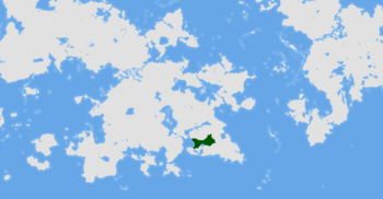
|map_caption = Location of ''' | [[File:Yugoslavia in Anteria.png|upright=1.15|frameless|Yugoslavia in Anteria]]|Yugoslav territories in Anteria| | ||
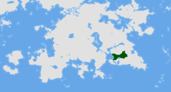
|capital = | [[File:Yugoslavia in Southern Thrismari.png|upright=1.15|frameless|Yugoslavia in Thrismari]]|Yugoslavia in Thrismari| | ||
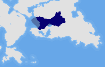
|largest_city = | [[File:Yugoslavia, and its exclusive economic zone.png|upright=1.15|frameless|Yugoslavia, and its exclusive economic zone]] | ||
|national_languages = | |Yugoslavia, and its exclusive economic zone|Labelled map|default=1}} | ||
|official_languages = | |map_caption = Location of '''Yugoslavia''' (blue or dark green) | ||
|languages_type = Slavic | |capital = Chernograd | ||
|ethnic_groups = | |largest_city = Chernograd | ||
|ethnic_groups_year = | |national_languages = Chernogorkan, Cordomonivence Slavonic | ||
|demonym = | |official_languages = Chernogorkan | ||
|government_type = | |languages_type = Slavic | ||
|leader_title1 = | |ethnic_groups = Chernozemci (43%) <br> Gorkanki (31%) <br> Storonci (11%) <br> Morrawian (9%) <br> Other (6%) | ||
|leader_name1 = | |ethnic_groups_year = 2019 | ||
|leader_title2 = | |demonym = Yugoslav | ||
|leader_name2 = | |government_type = Parliamentary democracy under a constitutional monarchy | ||
|legislature = The Federal | |leader_title1 = King of Yugoslavia | ||
|upper_house = The | |leader_name1 = [[King Paul I of Yugoslavia|Paul I]] | ||
|lower_house = The House of | |leader_title2 = Prime Minister | ||
|leader_name2 = Nikolaj Novosel | |||
|legislature = The Federal Assembly of Yugoslavia | |||
|upper_house = The Royal Council | |||
|lower_house = The House of Peoples | |||
|sovereignty_type = | |sovereignty_type = | ||
|sovereignty_note = | |sovereignty_note = | ||
|established_event1 = | |established_event1 = Arrival of the Slavs | ||
|established_date1 = | |established_date1 = 6th century | ||
|established_event2 = | |established_event2 = Duchy of Gorka | ||
|established_date2 = | |established_date2 = 10th century | ||
|established_event3 = | |established_event3 = Great Peasant Rising | ||
|established_date3 = | |established_date3 = 1493 | ||
|established_event4 = | |established_event4 = Kingdom of Gorka | ||
|established_date4 = | |established_date4 = 1711 | ||
|established_event5 = Kingdom of | |established_event5 = Kingdom of Chernogorka | ||
|established_date5 = | |established_date5 = 2nd February 1848 | ||
|established_event6 = | |established_event6 = Unification referendum | ||
|established_date6 = | |established_date6 = 18th November 1953 | ||
|established_event7 = | |established_event7 = Federation of Yugoslavia | ||
|established_date7 = | |established_date7 = 14th January 1955 | ||
|established_event8 = | |established_event8 = Coronation of Paul I | ||
|established_date8 = 1st | |established_date8 = 1st December 1992 | ||
|area_km2 = | |area_km2 = 486,255.971 | ||
|area_label = Total | |area_label = Total | ||
|population_estimate = 87 467 105 | |population_estimate = 87 467 105 | ||
Revision as of 20:18, 21 November 2023
Royal State of the Federation of Yugoslavia Koroljevska Deržava Federacije Jugoslavije (Chernogorkan)
Королйевска Держава Федерацийе Йугославийе (Cyrillic) | |
|---|---|
| Motto: Jeden narod, jeden korolj, jedna deržava "One people, one king, one state" | |
| Anthem: "Hej Slaveni!" "Hey Slavs!" | |
Location of Yugoslavia (blue or dark green) | |
| Capital and largest city | Chernograd |
| Official languages | Chernogorkan |
| Recognised national languages | Chernogorkan, Cordomonivence Slavonic |
| Ethnic groups (2019) | Chernozemci (43%) Gorkanki (31%) Storonci (11%) Morrawian (9%) Other (6%) |
| Demonym(s) | Yugoslav |
| Government | Parliamentary democracy under a constitutional monarchy |
• King of Yugoslavia | Paul I |
• Prime Minister | Nikolaj Novosel |
| Legislature | The Federal Assembly of Yugoslavia |
| The Royal Council | |
| The House of Peoples | |
| Establishment | |
• Arrival of the Slavs | 6th century |
• Duchy of Gorka | 10th century |
• Great Peasant Rising | 1493 |
• Kingdom of Gorka | 1711 |
• Kingdom of Chernogorka | 2nd February 1848 |
• Unification referendum | 18th November 1953 |
• Federation of Yugoslavia | 14th January 1955 |
• Coronation of Paul I | 1st December 1992 |
| Area | |
• Total | 486,255.971 km2 (187,744.480 sq mi) |
| Population | |
• 2020 estimate | 87 467 105 |
• September 2015 census | 84 234 149 |
• Density | 182.09/km2 (471.6/sq mi) |
| GDP (PPP) | 2020 estimate |
• Total | 3,774 TRILLION |
• Per capita | 43 131 ACU |
| GDP (nominal) | 2020 estimate |
• Total | ACU 2,941 TRILLION |
• Per capita | ACU 33 611 |
| Gini (2017) | medium |
| HDI (2018) | very high |
| Currency | Morrawian Tollar (₮) 1:4.17 conversion with real dollar |
| Time zone | UTC 0, UTC +3 and UTC +6 |
| Date format | dd-mm-yyyy |
| Driving side | right |
| Calling code | +415 |
| ISO 3166 code | MO |
| Internet TLD | .mo |
The Federation of Yugoslavia, officially the Royal State of the Federation of Yugoslavia (Chernogorkan: Koroljevska Deržava Federacije Jugoslavije, Королйевска Держава Федерацийе Йугославийе; known informally as Yugoslavia) is a country located in the Southeastern Thrismari. It is surrounded by Lindstaten to the north, Wassilia to the east, Sacrofnia and the Kolpa Lake to the south, and the Kaldaz Ocean shoreline to the west. It's three federated units, krajine/крайине, and the capital district comprise a total area of 486,255.971 km2 (187,744.48 square miles), on which reside 83,772,916 residents (2019 Census), corresponding to 172.28 per km2 (446.21 per sq mi). Yugoslavia is a parliamentary democracy under a constitutional monarchy, ruled by king Paul I of the House of Karažev since 1992. The federal capital is Chernograd (Chernogorkan: Černograd, Черноград; lit. black city), a city of more than 8 million people situated on the shores of Kolpa Lake; the city is the financial, industrial, and scientific centre of Yugoslavia, hosting the Royal Institute of Science and the University of Chernograd. The entire nation is mostly flat in the interior; the littoral region is moderately hilly and uneven, while the eastern borderlands with Wassilia are composed of mostly low summits and peaks of the Trizub mountain range. The highest summit is in the northeasternmost corner of the country, Sventovid Peak, measuring at 2,063 metres above sea level.
The first traces of human activity in the lands of contemporary WORK IN PORGRESS


