Kiyortza
United States of Kiyortza Kiyortzani Linsori Vyarikin | |
|---|---|
|
Flag | |
 | |
| Capital | Kyrisje |
| Largest city | Loržika |
| Official languages | Kanesli Rijaki Ikari Norita Rukoči Žinasi Lorfier Ifarszi Astari |
| Ethnic groups | Several, TBA |
| Demonym(s) | Kiyortzani |
| Government | Democratic Federal Republic |
• President | Jaro Ilhassn |
| Legislature | Parliament |
| Establishment | |
• Union established | July 16, 1607 |
• First Republic established | April 5, 1769 |
| Area | |
• Total | 1,657,269 km2 (639,875 sq mi) |
| Population | |
• 2020 census | 194,416,610 |
• Density | 118.26/km2 (306.3/sq mi) |
| GDP (PPP) | estimate |
• Total | 7.396 Trillion KJI ($9.763 Trillion ACU) |
• Per capita | 38,125 KJI (50,325 ACU) |
| GDP (nominal) | 2019 estimate |
• Total | 6.477 Trillion KJI (8.55 Trillion ACU) |
• Per capita | 33,388 KJI (44,072 ACU) |
| HDI (2020) | 0.911 very high |
| Currency | Kijorsi (KJI) |
| Time zone | UTC-8 (KJS) |
| Driving side | left |
| Calling code | +19 |
| Internet TLD | .kj |
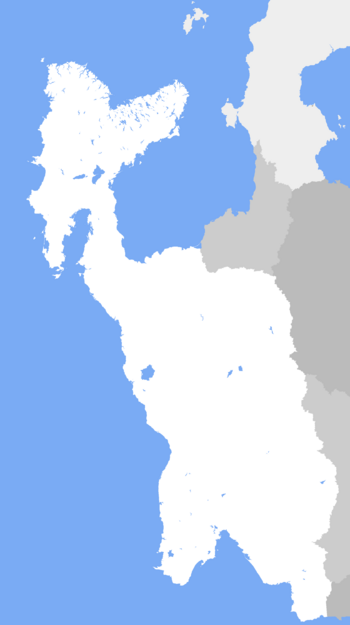
Kiyortza (Kanesli: Kijorca), formally the Federal Republic of Kiyortza, is a country in northwestern Thuadia, nestled largely between the Paisi Ocean to its west and Vaali Mountains to its east, with a handful of island possessions, including most prominently the island of Žinat and the islands of Irkylis and Nikorva. Covering an area of about 1.65 million square kilometers, it shares a land border with the nations of Astariax, Askye, Vescarium, and Fichmanistan, all to its east, while all of its remaining boundaries are dictated by sea.
Southern Kiyortza, alongside regions of nearby Vescarium, is thought to be one of the early cradles of civilization, tracing much of its history back six to seven millenia alongside the Tanesi and Rijaga Rivers, abundant sources of water in an otherwise dry and fairly unwelcoming landscape of desert and chaparral. For several millenia, the civilizations of southern Kiyortza were the dominant power west of the Vaalis, though with the emergence of civilizations further north within the flat plains of the Itikov and Alf Rivers, the region soon became divided between north and south, separated primarily by the Fukulji Mountains. As such, until more recently, the states within Kiyortza had been undergoing a perpetual cycle of expansion, conquest, and refracturing.
By the 16th century, the borders that would define modern Kiyortza's internal and externals borders had mostly taken shape, between the Ikari conquests of Astari land, Rijaki occupation of western Ifarszia, and the creation of Kanesli Akesda; by the early 17th century, the nation of Kiyortza was formed through personal union between the Kanesli and Viškari crowns, bringing a brief period of prosperity. By the mid-18th century, however, the rising price of basic goods due to recent conflicts and large amounts of corruption within the regime soon brought widespread discontent, eventually leading to the Kiyortzai Revolution of 1761, the dissoultion of the monarchy, and formation of the First Kiyortani Republic in 1769.
WIP
