User:BrackishWater/Sandbox1
This article is incomplete because it is pending further input from participants, or it is a work-in-progress by one author. Please comment on this article's talk page to share your input, comments and questions. Note: To contribute to this article, you may need to seek help from the author(s) of this page. |
Cybernetic-Socialist State of Lemaire Lemaire | |
|---|---|
|
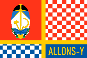
Flag | |
| Motto: Allons-Y! Off We Go! | |
| Anthem: L'internationale (official) L'internationale | |
| Capital | Montravaille |
| Largest city | Portage Rouge |
| Official languages | Essonique |
| Recognised national languages | Isabellan, Shediac, Écoz (Lemairien Creole), Giduwa |
| Demonym(s) | Lemairien (ethnic) Lemairien (citizen) |
| Government | Technocratic-Syndicalist State |
| Esprit Rouge | |
| Zealia de Marigny | |
| Legislature | Collège des Cybernéticiens |
| Establishment | |
• Duchy of Lemaire | 1551-1682 |
• Viceroyality of | 1782-1890 |
• Outremer Republic of Maraison | 1890-1936 |
• Commune of Lemaire | 1933-1939 |
• Cyberneticist Coup | 1940-1943 |
| Population | |
• 2023 estimate | 62,590,000 |
• 2020 census | 62,561,011 |
| Date format | dd.mm.yyyy |
| Driving side | right |
| ISO 3166 code | MAR |
| Internet TLD | .mar |
Lemaire, officially the Cybernetic-Socialist State of Lemaire (Ecosse: État Cybernétique-Socialiste du Lemaire), is a country in the northern portion Cesylle in Cel. It is bordered to the north by Druermark, to the east by the Teredo Sea, to the south by Elaklania, and to the west by the [Blank Country]. Lemaire is organized as a centralized Technocratic state with Syndicalist elements, and is divided into [A number] Industrial Development Axes, [A larger number] Collectivized Parishes, and [A small number] Traditionally-Governed Administrative Zones. The city of Montravaille serves as the nominal capital, though no city officially has that status.
Humans have been present in the region that would become Lemaire since [Date humans settled Cesylle]. The braided river systems of the Maraisian Bottom has played host to a number of intertwining civilization, including the Ramey Culture, the Nequasee, the Hacha Hatak, and the Inoka. The Italwa were the dominant power at the time of initial contact with the Essonic "Forster" people. In 1589 a civil war rocked the Italwa state, and lead to the placement of a mixed Essonic-Italwan king on the throne in Kituwa, and ultimately the subjugation of the Italwan polity as a vassal of the kingdom of Esson. Over the course of the next 3 centuries Essonic settlement of the lands of Italwa would move steadily inland. Manorial plantations growing cotton displaced Three Sisters agriculture, making Lemaire the most productive cotton-growing region on Cel. Direct Essonic control of Lemaire would end in 1799 with the establishment of the "Viceroyalty of Italwa".
Etymology
Lemaire is a term from the Essonic Forster dialect for a village headman, and is demonym the Italwa used for their Essonic subjects. During the colonial period the names Lemaire and Italwa were both in use, the two terms designating lands governed by Creoles or Natives. With the acendancy of the Viceroy the whole region would again be referred to as Italwa, and the term Lemaire become largely defunct until the Arendelle Declaration resureccted the term to refer to the developing Creole national identity. Controversially, the socialist government still primarily uses the name Lemaire, despite the persistent complaints of the leadership of the Giduwa people, many of whom consider the term an offensive reminder of the erasure of their people from the history of the region.
History
Antiquity
Italwan Confederacy
Duchy of Lemaire and Italwa
Viceroyalty of Italwa
First Great War
Outremer Republic of Lemaire
Economic Failure
Commune of Lemaire
Second Great War
Impact
Cybeneticist Coup
Quiet Duel Onwards
Politics
Governance
Aosta is constituted of many local and regional communes that are governed according to each commune’s preference, although most communes elect their leadership through direct democracy. Most of these communes participate in the Free Assembly of the People where issues can be brought to the attention of other communes and they can coordinate a response. Matters of international importance are also coordinated through the Assembly as it is the internationally recognized legal representation of Aostan society.
Administrative Divisions
The lowest administrative division in Aosta is the commune, which is a municipal designation. Communes that share a heightened level of local cooperation, culture, or important geographical landmarks are organized into provinces. These provinces are then further grouped into regions, which serve as the highest administrative division. Provinces and regions often, but not always, maintain a council composed of representatives from their constituent communes who provide macroeconomic analysis to their constituent communes.
Largest Cities
Rivoluzione Carcosa Ignis Lorica Brixias
Foreign Relations
Aosta is an active member of the Alliance for Socialist Liberation and the International Assembly. It is well known for its medical and humanitarian internationalism. It has tenuous ties with Ilbon after the 1994 Koai Protests, during which the Ilbonese government harshly cracked down on student and anarchist protesters, and [BLANK], which ceded its southern peninsula to Aosta at the end of the Second Great War.
