National roads of Emerstari
This article is incomplete because it is pending further input from participants, or it is a work-in-progress by one author. Please comment on this article's talk page to share your input, comments and questions. Note: To contribute to this article, you may need to seek help from the author(s) of this page. |
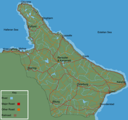
National roads (Emerstarian: riksvag; literally: country's road) in Emerstari have road numbers from 1 to 90, with 1 to 27 being Hogrutter (English: High routes). Generally, roads with lower numbers are in eastern Emerstari, and roads with higher numbers are in western Emerstari. There are numerous cases in this system where two or more routes share the same physical road for a considerable distance.
The national roads are public roads owned by the federal Government of Emerstari and administered by the Emerstarian Transportation Administration. They get a high priority for snow plowing during the winter.
The roads' number signs are rectangular with a blue background with a white number topped by the Tred Kroner with a white border.
National roads
| Number | Beginning point | Ending point | Length (mi) | Length (km) |
|---|---|---|---|---|
| 1 | Kalamer | Ljund | 117 | 188 |
| 2 | Kalamer | Yoerk | 376 | 605 |
| 3 | Yoerk | Uppsalle | 217 | 349 |
| 4 | Uppsalle | Stoghjem | 215 | 346 |
| 5 | Stoghjem | Olskrone | 216 | 348 |
| 6 | Ljund | Yoerk | 349 | 562 |
| 7 | Kalamer | Osterburg | 322 | 518 |
| 8 | Ljund | Osterburg | 216 | 348 |

