Lyhoming
This article is incomplete because it is pending further input from participants, or it is a work-in-progress by one author. Please comment on this article's talk page to share your input, comments and questions. Note: To contribute to this article, you may need to seek help from the author(s) of this page. |
State of Lyhoming | |
|---|---|
State | |
| Nickname(s): The Frontier State (official) The Wild State | |
| Motto: | |
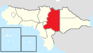
 Map of Rizealand with Lyhoming in red | |
| Country | |
| Before Statehood | Eastern Territory |
| Capital (and largest city) | McDowell |
| Joined Federation | November 8, 1890 (7th) |
| Government | |
| • Governor | Paul Barthelemy (TNC-CRP) |
| • Deputy Governor | Megan Campbell (TNC-CRP) |
| • Legislature | Lyhoming State Assembly |
| • Federal representation | Councilors
|
| Area | |
| • Total | 283,733.60 km2 (109,550.16 sq mi) |
| Population (2021) | |
| • Total | 6,016,900 |
| • Density | 21.21/km2 (54.9/sq mi) |
| Time zone | UTC+10 (Central) |
| Abbreviation | LY |
| ISO 3166 code | RZ-LY |
| Website | www |
Lyhoming, known officially as the State of Lyhoming and unofficially as "LY" or "Lyho", is a state in eastern Rizealand that is bordered by Cassier to the north, the Powhatan Nation to the northeast, Cahoka to the southeast, Marchenia and San Andreas to the south, Fáel and the Nehinaw Nation to the southwest, and Providence to the west. Lyhoming has a total area of 283,733.60 square kilometers, making it the second largest state and political division of Rizealand. Lyhoming also has a population of 6,016,900, making it the fourth most populous state and political entity in Rizealand. Lyhoming's capital and largest city is McDowell. It is also home to several other large cities including Shelby, Greendale, and Jedburg.
Etymology
The name "Lyhoming" is derived from the Powhatan word "Ly'homa'inke", meaning "river-crossed." The Powhatan used the name to refer to the Weanoke River which cuts through the center of the state.