Principality of Lower Streckeburg
Principality of Lower Streckeburg Fürstentum Niederstreckeburg (Alemannisch) | |
|---|---|
| 1428 | |
 | |
| Status | State |
| Capital | Münthal |
| Common languages | Alemannisch |
| Demonym(s) | Lower Streckeburger |
| Government | Principality |
• Prince | Adelbert VII |
| History | |
• Partitioned from Streckeburg | 1428 |
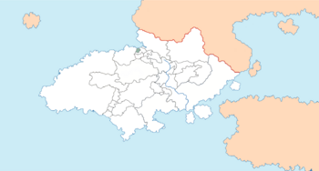
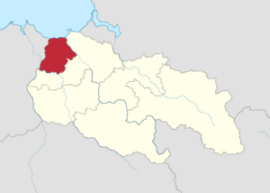
Lower Streckeburg (Allemanisch: Niederstreckeburg), officially the Principality of Lower Streckeburg (Allemanisch: Fürstentum Niederstreckeburg), is a semi-independent constituent state of Dolchland. Lower Streckeburg is located in the Drei Flüsse region of Dolchland. It is bordered by Kirchmarkt and Teilen to the south and east, and by ($STATE) to the west, with a coastline onto the Morthal Bay. The state's capital, Münthal, was originally a small trade post on the coast, before developing into a medium-sized town. Lower Streckeburg gains its name from Streckeburg Castle, located in Upper Streckeburg, from which the state was partitioned with the death of Benedikt of Streckeburg and the subsequent cession of Teilen to the bishop of Kirchmarkt, confirmed by the Treaty of Mittelsdorf in 1437.
History
Unified Principality
Post-partition
Modern history
Geography
Location

Upper Streckeburg lies between the Unter, Weit and Blatt rivers, comprising the eastern and part of the southern and western borders respectively.


