User:Gibia/sandbox2
Sacred Kayahallpan State | |
|---|---|
|
Flag | |
| Anthem: "Kayahallpa Llaqta Takin" (Kaya Simi) "National Anthem of Kayahallpa" | |
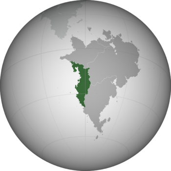
 Location of Kayahallpa in Oxidentale | |
| Capital | Tupawasi |
| Official language | Kaya Simi |
| Spoken languages | newname newname newname Apa Simi Itukali Simi various others |
| Ethnic groups | |
| Demonym(s) | Kayahallpan, Kayan, Warian |
| Government | Theocratic technocratic republic |
• Kamasqa | Qaparipuyll Wuluk |
• Great State Council | 8 members |
| Legislature | Chosen Court |
| Formation | |
• Chincha civilization | 4000 BCE |
• Wari federation | 480 CE |
• Warisuyu | 1045 |
• New Kayamucha | 1434 |
• Restoration of New Kayamucha | 1818 |
• Constitutional Reformation | 1927 |
• Monarchy abolished | 1956 |
• Kayahallpan Revolution | 1960 |
| Area | |
• | 1,414,464 km2 (546,128 sq mi) |
• Water (%) | 1.2 |
| Population | |
• 2020 census | 64,226,754 |
• Density | 45.5/km2 (117.8/sq mi) |
| GDP (nominal) | 2020 estimate |
• Total | $919.8 billion |
• Per capita | $14,321 |
| Gini (2015) | 42.3 medium |
| HDI (2018) | high |
| Currency | Qullqi |
| Date format | dd/mm/yyyy |
| Driving side | right |
| Calling code | 36 |
| ISO 3166 code | KY |
| Internet TLD | .ky |
Kayahallpa (Kaya Simi: Kayahallpa [kajaˈhaʎpa]), also called Wari, and officially the Sacred Kayahallpan State, is a country in western Oxidentale. It borders the Mutul to the north, Sante Reze and Yadokawona to the east, Zacapican to the south-east and the Makrian Ocean to the west. The country has three constitutionally defined capital cities: the "greater capital" of Tupawasi in central Kayahallpa, and the "lesser capitals" of Mayunrispampa in the north and Huirquihui in the south. It has a population of 65 million and its largest city is Tupaq Churan City.
Kayahallpa has been home to many cultures stretching back at least 6000 years including the coastal Chincha civilization, the old Nahuas, the highland Warisuyu Empire, and the current Kayan society. While its history has been shaped by a number of global powers, Kayahallpan territory has almost always been ruled by Oxidentalese states.
The modern state of Kayahallpa traces its origin to the ancient Kayans, who migrated from Norumbia due to the 14th century socio-economic collapse of the Kayamuca Empire and waged war against the native Warisuyu Empire. After the Warisuyu collapsed with the 1376 Fall of Tupawasi, the competing Kayan clans fought for supremacy with the Wiraqucha Clan ultimately winning and establishing the New Kayamucha in 1434 CE. The New Kayamucha lasted until the advent of the 17th century, when the rise of the Mutuleses colonial empire brought with it incursions into the Kayahallpan coast. A series of wars brought Kayan power into a steady decline, which never recovered. Most of Kayahallpa was converted to Sakbeism under Mutunese dominion. Beginning in 1791, the post-Kayamuchan ruler Tupaq Churan launched a series of military campaigns and fought against the Mutulese and their subjects, officially restoring the New Kayamucha. The inability of his descendants to reconcile internal frictions and avoid costly wars led to the 1924-1927 Kayahallpan Spring, a period of rapid internal changes which led to democratic reforms. The Kayan Workers' Party dominated elections and led the country into a profound wave of industrialization and liberalization, but also provoked the ire of traditionalist and nationalist factions. In the late 1950s, KWP leader Kaman Yashakphi began to centralize power under a one-party ordosocialist system and expelled the last monarch, Tupaq Yupanki III. Yashakphi was overthrown in the 1960 Kayahallpan Revolution, which established a 'revolutionary and divine republic' under Kamasqa (Divine Priest) Pitiy Achtil, followed by a decade of unrest as the socialist RAA launched a guerilla campaign against the Kamasqa.
The Government of Kayahallpa is a Sakbeist theocracy, spiritually and temporally led by the Kamasqa, with technocratic elements. The current Kamasqa is Qaparipuyll Wuluk, in office since 2005, who exerts power with the Great State Council. There is a legislature, but it has little if any power. It is a developing country with medium-high human development levels and a middling economy. Much of Kayahallpa is arid, with large plateaus and mountain ranges covering most of its land area. While the country has a long coastline, much of it is sparsely populated desert, occasionally broken up by heavily populated river basins and mist oases. Large parts of the country are irrigated for agricultural production. At 1.412 million square kilometers in area, it is the fourth largest country in Oxidentale. Sante Reze and the Mutul are Kayahallpa's largest trade partners and have been its closest allies after the Kayahallpan Revolution. Kayahallpa is a member of the Common Congress and the Forum of Nations, among other international organizations.
The country's population of almost 65 million comes from a variety of backgrounds, mainly indigenous to Oxidentale as well as significant Norumbian and Malaioan descent. Kaya Simi is the national language, and co-official with a local language in most regions. Increases in agricultural efficiency and the abolition of settlement restrictions facilitated rapid urbanization in the mid to late 20th century, which transformed the political, social, cultural, and economic landscape of the country.
