Trelk
Jump to navigation
Jump to search
| Trelk | |
|---|---|
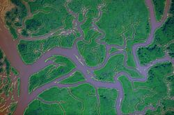
 Corrected false colour image of the Trelk on the Dangish-Namijan border | |
| Location | |
| Countries | |
| Physical characteristics | |
| Length | 246.3 kilometres (153.0 mi) |
| Basin size | 17,300 square kilometres (6,700 sq mi) |
| Basin features | |
| Cities | Trelkagar |
The Trelk is a complex river system on the border between Dungeyland and Trellin. Its main sources lie in eastern Namija, on the slopes of Vekhilan, and western Dungeyland, in the Intel region. With a maximum length from source to mouth of 246.3 kilometres (153.0 mi), it is the fifth largest river system in Namija, draining 17,300 square kilometres (6,700 sq mi) of the principality's southeast. The river splits and rejoins many times along its course, and there is no definite 'main stem.' The current international border follows a line surveyed in 1861 that in many places does not correspond to the river's current shape. The Trelk enters the Sea of Velar in a broad delta with the port city of Trelkagar built on its northern bank.