Cahoka
This article is incomplete because it is pending further input from participants, or it is a work-in-progress by one author. Please comment on this article's talk page to share your input, comments and questions. Note: To contribute to this article, you may need to seek help from the author(s) of this page. |
State of Cahoka | |
|---|---|
State | |
| Nickname(s): The Sunrise State (official) The Big State | |
| Motto: | |
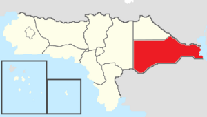
 Map of Rizealand with Cahoka in red | |
| Country | |
| Before Statehood | Eastern Territory |
| Capital | Cahoka City |
| Largest city | Gadsen |
| Joined Federation | February 15, 1905 (8th) |
| Government | |
| • Governor | Roy Lamb (TNC-CRP) |
| • Deputy Governor | Amy Butler (TNC-CRP) |
| • Legislature | Cahoka State Assembly |
| • Federal representation | Councilors
|
| Area | |
| • Total | 325,264.91 km2 (125,585.48 sq mi) |
| Population (2021) | |
| • Total | 3,824,043 |
| • Density | 11.76/km2 (30.5/sq mi) |
| Time zone | UTC+10 to +11 (Central/Eastern) |
| Abbreviation | CA |
| ISO 3166 code | RZ-CA |
| Website | www |
Cahoka, known officially as the State of Cahoka, is a state in eastern Rizealand that is bordered by the Powhatan Nation to the northwest, Cassier to the northeast, Lake Weanoke and Chistovodia to the east, Marchenia to the south, and Lyhoming to the west. Cahoka has a total area of 325,264.91 square kilometers, making it the largest state and political division of Rizealand. Cahoka also has a population of 3,824,043, making it the sixth most populous state and political entity in Rizealand. Cahoka's capital city is Cahoka City and its largest city is Gadsen.
Etymology
The "State of Cahoka" is named after the ancient Nimarew city of Cahoka near present-day Cahoka City in the center of the state. The ancient city of Cahoka was also called "El Dorado" and was rumored to be a city made out of gold. More recent archeological excavations however have determined that Cahoka was not a golden city but was a major trading, cultural, political, and economic center for the Nimarew in eastern Rizealand.
