Kitaubani
This article is incomplete because it is pending further input from participants, or it is a work-in-progress by one author. Please comment on this article's talk page to share your input, comments and questions. Note: To contribute to this article, you may need to seek help from the author(s) of this page. |
Kingdom of Kitaubani Masarautar Kitaubani (Hausa) | |
|---|---|
| Motto: Umoja katika Utofauti Unity in Diversity | |
| Anthem: "Local name" "O, Kitaubani" | |
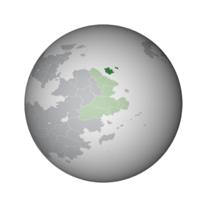
 Kitaubani (dark green) within the Congress of Bahian States (light green) in Bahia | |
| Location | Bahia |
| Capital | Kwamuimepe |
| Largest city | Gashi |
| Official languages | Hausa, Watuajua |
| Ethnic groups (2023) | |
| Religion (2023) | List
|
| Demonym(s) | Kitauban |
| Government | Unitary constitutional monarchy |
• Queen | Medare I |
• Premier | Balarabe Zango |
| Independence from Werania | |
| Area | |
• | 259,786.24 km2 (100,304.03 sq mi) |
| Population | |
• 2023 estimate | 21,974,231 |
| GDP (PPP) | 2023 estimate |
• Total | $371,210,684,283 (37th) |
• Per capita | $16,893 (40th) |
| GDP (nominal) | 2023 estimate |
• Total | $143,667,522,278 (51st) |
• Per capita | $6,538 (58th) |
| Currency | Kitauban wuri (₩) (KIW) |
| Time zone | UTC+3 (BST) (Khardjiba Island: +4) |
| Driving side | right |
| Calling code | +27 |
| Internet TLD | .ki |
Kitaubani, known officially as the Kingdom of Kitaubani, is a sovereign state located off the coast of Bahia. An island nation, it shares a maritime border with Asase Lewa and Sabaw to the southeast. The current population of 21,974,231 people is spread across 259,786 square kilometers, making Kitaubani one of the more moderately-dense nations in Bahia at 84 persons per square kilometer.
The islands presently known as Kitaubani were inhabited since ancient times by numerous groups, such as the Hausa and the Tamasheq. These groups frequently associated with one another and with their cohorts on the Bahian mainland through a cross-channel trade network. City-states were beginning to form on the coasts, which interfaced with the more nomadic groups in the hinterlands through trade, diplomatic marriage and warfare. These patterns of interaction were interrupted in the early Houregic Period. In the mid-eleventh century CE, a Watuajua ruler known as Mataka fled warfare in his home in modern-day Maucha. Mataka's arrival in Kitaubani presaged many of his followers', which included a significant merchant caste that soon dominated the city of Gashi. For around a century, Gashi operated indistinctly from other coastal Kitauban city-states. By the end of the twelfth century, however, Gashi's Watuajua rulers had begun attacking neighboring city-states, either to annex them or force them into tributary status. This eventually transformed into the elite of Gashi holding at least nominal control of most of the Kitauban islands by the 1500s. To this day, Mataka's initial takeover of the village of Gashi is seen as the direct predecessor of the modern Kitauban state, and Mataka himself is considered in the popular consciousness as the first mfalme, or Watuajua ruler of Kitaubani.
Presently, the Kingdom of Kitaubani is ruled as a constitutional monarchy under the guiding principle of parliamentary sovereignty. The government retains moderately low corruption and high transparency scores. It is a member of the Congress of Bahian States, the Community of Nations, the Council for Mutual Development and the International Forum for Developing States. Kitaubani maintains one of the stronger economies in Bahia, benefitting from a growth in urban manufacturing and its influence in the global shipping industry. Its nominal Gross Domestic Product (GDP) is the second-largest per capita in Bahia after Sabaw.
Etymology
The name Kitaubani likely derives from a Watuajua-language phrase, though it has been altered to fit Hausa language phonology. Following the Bahian consolidation during the Houregic Age, an expedition led by mfalme Mataka, landed on the shores of Kitaubani at the site of modern-day Gashi. Mataka had fled his homeland of modern-day Maucha both to escape violence at home and to re-establish his wealth through new economic holdings. After a long journey fraught with adverse conditions, conflicts with local authorities, and other innumerable hardships, was the island of Kitaubani: according to popular folklore, in his relief at completing his journey, Matake proclaimed the site kituo wa pwani, or the Coast of Respite. As Mataka carries an almost-mythified status in Kitauban consciousness as one of the first kings of the island, this story has persisted and grown to be the most popular folk etymology for the name of the country. The name Kitaubani can apply both to the country and to the larger island within the country; the latter is frequently termed "Kitaubani Island" or "the Isle of Kitaubani" to avoid confusion.
History
Geography
Climate
A combination of prevailing trade winds to the south and the central highlands of Kitaubani Island have shaped the nation's climate. The south experiences nearly sub-tropical precipitation, though retains average temperatures well within the temperate zone thanks to the island's latitude and the moderating effects of the ocean. The north of the island lies within a rain shadow created by the central highlands, creating more arid and variable conditions. Khardjiba Island experiences a similar arid-temperate climate to the north of Kitaubani Island.
As Kitaubani lies on two islands, the country is home to numerous endemic species and variants not found elsewhere in the world.
Administrative divisions
Kitaubani is subdivided into 22 departments, further subdivided into districts. These districts are centered around a significant autonomous settlement with a city council, with the remaining territory divided into wards overseen by municipal, village, or rural councils. The departments of Kitaubani were drawn for the most recent time in 1970, designed to roughly correspond to equal population size per district. Due to substantial industrialization and urbanization in the intervening decades, however, there now exists a substantial population disparity between rural and more urbanized departments.
Demographics
Ethnicity
Language
Hausa and Watuajua, through their historical prominence, have retained their positions as dual linguae francae across the island. Some students elect to learn Weranian as a foreign language, though for many decades this was discouraged due to political reasons.
Education
Religion
Government
Kitaubani is a unitary constitutional monarchy, governed under its 1969 Constitution. The head of state is Queen Medare I. Under the Kitauban Constitution, the monarch holds mostly symbolic power. Most real executive authority lies with the parliamentary head of government, a title often translated as Premier. Currently, the Premier is Balarabe Zango of the X Party. The Premier is elected from the ranks of Kitaubani's parliament, the National Assembly. Under the principle of parliamentary sovereignty, the legitimacy of the Kitauban government is meant to derive from the citizenry through voting for representatives in the parliament.
Economy
Kitaubani is often categorized as an developing or emerging nation. Through a burgeoning industrial sector and nascent services sector, along with footholds in the global shipping industry, the nation has maintained one of the stronger economies in Bahia. Kitaubani holds the second-highest Gross Domestic Product (GDP) per capita in terms of Purchasing Power Parity (PPP) in Bahia, second only to Sabaw. Additionally,


