Vegi Kroreg
| Vegi Kroreg | |
|---|---|
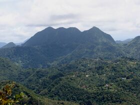
 Vegi Kroreg (left, two summits) and Vegi Sailad (right) | |
| Highest point | |
| Elevation | 1,109 m (3,638 ft) |
| Prominence | 1,109 m (3,638 ft) |
| Listing | Country high point Haele-Rismikhar |
| Geography | |
| Location | Northern Kur'zhet |
| Parent range | Peren Bandego |
Vegi Kroreg (Kuredt meaning "thunderous mountain") is an extinct volcano on the island of Aizhet. It is the tallest mountain in Kur'zhet, at 1,109 m (3,638 ft), and the main massif of the country's Peren Bandego, or Northern Range. After Cadenza's Vekh Neramë, it is the second highest point west of Azmir within the Trellinese Empire, and is the shortest Haele-Rismikhar mountain. Its summit is the meeting point of the Kur'zheti earldoms of Apal, Barb and Ma 'ntarin.
There are three tops in the Vegi Kroreg massif. The southernmost of these, Vegi Sailad, is considered a distinct mountain by hikers with its prominence of 127 m (417 ft) and reaches a height of 1,075 m (3,527 ft). Vegi Kroreg's south top is 500 m (1,600 ft) from the north and reaches a height of 1,069 m (3,507 ft). From some angles (as in the photograph on this page), because of the distance between the two, the ridge between the north top and south top appears to include another high point, but its prominence is insignificant.
The mountain's name suggests its volcanic past, but it is not thought to have erupted within the last 140,000 years, whereas the Ethlorek settlement of Kur'zhet occurred c. 112 BC. The massif was initially formed by tectonic activity in what is now western Azmir, and its height was built up through further volcanism. It is thought that the mountain's name refers not to volcanic activity but to the sounds of earthquakes, which continue to shake Kur'zhet periodically, or perhaps to tropical thunderstorms that gather in the Peren Bandego.