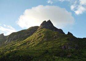
Vekh Neramë
| Vekh Neramë | |
|---|---|
 | |
| Highest point | |
| Elevation | 1,163 m (3,816 ft) |
| Prominence | 1,163 m (3,816 ft) |
| Listing | Country high point Haele-Rismikhar |
| Geography | |
| Parent range | Akar Tarpeg |
| Climbing | |
| Normal route | Ryt Tarmarin |
Vekh Neramë is the tallest mountain on the island of Cadenza. At 1,163 m (3,816 ft), it is the highest peak in the Akar Tarpeg, Cadenza's Central Range. It is the most westerly summit above 1,000 metres in the Trellinese Empire and the only mountain taller than 1,000 m in Cadenza. It is the only Haele-Rismikhar mountain in Cadenza. Vekh Neramë is 184 m (604 ft) taller than the next highest summit in Cadenza, Vekh Lamanë, and 54 m (177 ft) taller than the high point of Kur'zhet, Vegi Kroreg. An extinct volcano, Vekh Neramë is thought not to have erupted since approximately 325,000 years ago.
Name
In comparison to its neighbours, the origin of Vekh Neramë’s name is unclear. An eighth-century mariner's guide from Azmir refers to Vaekhra Narmegga "in the islands of the west," and some believe that this should be identified with Vekh Neramë. It has furthermore been suggested that the name refers to Narma, a minor Ethlorek deity associated with bonfires and hearths, although she does not appear in the surviving corpus of Cadenzan literature. Academics regard the divine dedication theory as plausible, given the dedication of the more southerly Vekh Lamanë to Arnyü, known in Cadenza as Lamauha, but the authoritative Toponymic Inventory of Cadenza remarks that "the argument is fundamentally inconclusive" and it remains uncertain.
Geology
Vekh Neramë is an extinct stratovolcano, initially formed during the Caddensian volcanic orogeny approximately 5 million years before present, when the Jajexan Plate traversed a hotspot in the Earth's asthenosphere. This hotspot now lies to the west of Cadenza and is responsible for ongoing volcanism offshore. The migration of the island away from the hotspot did not cause an immediate end to volcanism at Vekh Neramë, as fault line activity in Azmir continued to fuel Cadenza's volcanoes. In its most substantial known eruption, approximately 80% of Vekh Neramë's mass was ejected as tephra and smoke in one of the most significant volcanic events in Teudallic geological history. It is thought that the resulting ash cloud reduced global temperatures by 0.3 degrees Celsius. Mountain-building resumed following this eruption, with several episodes of dramatic change. Its last eruption, roughly 325,000 years ago, is thought to have had a VEI of 4. The surviving plug is composed of dense basalt, with large deposits of dark brown scoria and grey tephra on the flanks.
Geography

Vekh Neramë is the largest and highest mountain in the Akar Tarpeg, or Central Range, which makes up the majority of Cadenza's interior plateau. To its east is the High Pass, the main route between the northwest and southeast of the country, which divides the Akar Tarpeg from the Oredheri ti'Riim. The base of Vekh Neramë begins about 200 m (660 ft) above sea level and climbs quickly, its tephra flanks reposing at 45 degrees for the first third of its ascent. The climb then becomes gentler, at 30 degrees, but the ground remains rough and tumbled and heavily vegetated. The summit of Vekh Neramë is a massive wedge of exposed basalt, with sheer faces on all sides and an almost vertical descent on the peak's northwest face. Despite its notorious difficulty and numerous fatalities, mostly incurred on the northwest face, Vekh Neramë remains a popular climb. The summit is most commonly approached from the southwest, by way of the gentler Vekh Eddeg and along the ridge between the two mountains, Ryt Tarmarin. Its popularity is amplified by its status as Cadenza's sole Haele-Rismikhar mountain and the country's high point. The mountain offers unobstructed views to the northwest, far out to sea, to a distance of roughly 120 km (75 mi), and views over much of the east of the country. It is possible to see the hills of southwest Kur'zhet from the summit.
Below Ryt Tarmarin, at 221 m (725 ft) above sea level, is Gadana Neramë, a lake with a surface area of approximately 45 ha (110 acres). This lake lies in a cirque which was formed by ancient eruptions from a secondary vent of Vekh Neramë. The successive lahars collapsed the western face of the caldera, creating a cirque, and created the volcanic plain of eastern Lemithri.
With no other significant peaks to its west, the summit of Vekh Neramë is buffetted by strong westerly winds off the Sea of Jajich during the monsoon season. Wind speeds exceed 160 km/h (99 mph) several times a year on average, with the strongest gust on record some 264 km/h (164 mph), a product of 1983's Hurricane Tafarad.
Economic activities
A geological survey in 1966 identified economically significant deposits of zinc under the mountain's southeastern slopes. The Kur'zheti mining company Kurzink, which operated two zinc mines in the northwest of Cadenza, proposed to establish a mine on Vekh Neramë at 200 m (660 ft) above sea level. The proposal was quickly referred to the courts and drew major opposition from environmentalist advocates and polarised local communities. Kurzink spent the next twelve years in a legal battle as the proposal slowly worked its way up through the courts. A mail bomb at Kurzink's office in Benaan in 1975 was believed to be linked to the controversy. Kurzink itself filed for bankruptcy in 1976, after posting significant losses for three consecutive years. Eventually, Cadenza's Supreme and Constitutional Court directed the National Natural Resources Directorate to reject the proposal which was now in limbo, although its viability and legality were never resolved.
Cultural significance
The highest peak in Cadenza, Vekh Neramë has a similarly prominent place in Cadenzan culture.
