Riovenia
This article is incomplete because it is pending further input from participants, or it is a work-in-progress by one author. Please comment on this article's talk page to share your input, comments and questions. Note: To contribute to this article, you may need to seek help from the author(s) of this page. |
The Unitary Republic of Riovenia La República Unitária de Riovenia | |
|---|---|
| Motto: "Qui las difficultades, lutem." "May the difficulties, struggle" | |
| Anthem: "Ô Riovenia, Lembre del dia glorioso" O Riovenia, remember the glorious day | |
 | |
| Capital and largest city | Terroliva |
| Official languages | Riovenian |
| Ethnic groups |
|
| Demonym(s) | Riovenian |
| Government | Republic |
| WIPPP | |
| WIPP | |
| Legislature | National Assembly |
| Independence from Zoygaria | |
• Declared | 27 July 1910 |
• Constitution | 29 July 1910 |
| Area | |
• Total | 88,499 km2 (34,170 sq mi) (TBA) |
• Water (%) | 1,21% |
| Population | |
• July 2023 estimate | 28,869,785 (8th on the region) |
• 2014 census | 27,981,217 |
• Density | 326/km2 (844.3/sq mi) (TBA) |
| Gini (2016) | low |
| HDI (2023) | very high |
| Currency | Riovenian Cobre (RVC) |
| Time zone | UTC-5 |
| Driving side | right |
| Calling code | +123 |
| Internet TLD | .rv |
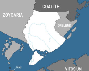
Riovenia, officially the Unitary Republic of Riovenia, is a country in southeast Nortua, consisting of a continental landmass and many islands in the Strait of Grelend. Riovenia is bordered by Zoygaria to the west, Coaitte to the north, Grelend to the east, and has maritime border with Vitosium to the south. It covers a territory of 88,499 square kilometers and is the 2nd southernmost country in Nortua. Terroliva is the nation's capital and largest city; other major cites include Bela Vid, Bataloni, and Monti Raiso. Riovenia's climate is typically characterized by a mediterranean climate, with a temperate climate on the west.
After decades of civil unrest, riots and vandalism, Riovenian independence from Zoygaria was declared in 27 July 1910, which was shared with Archravia. Riovenia agreed to be part of the Zoygarian commonwealth as part of the independence agreement and terms. Following the adoption of the first constitution two days after gaining independence, the first president, Júlio Agapov, was elected. Until the late 1940s, the riovenian economy was focused mainly on the export of agricultural goods, with the few industries being mainly construction centered. However this changed after the start of the World War in 1949, which helped industrialize the nation by the implementation of defense-based industry in the country's main cities. Riovenia was aligned with the League Forces during the World War. After the end of the World War, many of the industries built in the war were repurposed for multiple sectors, which led to a diversification of the economy and economy stability during the mid 1960s and the early 1970s. The economic industrialization not only strengthened the agricultural sector, which became known worldwide due to olive exportations, but also contributed to development of the automobile and appliance industry.
Riovenia is a unitary republic. The country has been member of the zoygarian imperial commonwealth since its foundation and joined the coalition of crown albatross in 1988. with a recurrent neutral view over foreign matters.
Etymology
The name Riovenia etymologically means either 'land of the river people ' or 'riverland', and is a modern form of the term "Rivusvĕnŭ", being the combination of both the words Rivus, which means river in latin, and the word vĕnŭ, which means people in former local slav languages. The term "Rivusvĕnŭ" was commonly attributed to the area east of the Quebrazuby Highlands in a unofficial yet popular manner. The use of the term decayed in use after the regionalization of the Zoygarian territory in 1876, by which the modern name of "Riovenia" was officially set to the new region. The term was retained post-independence not only because of the significant rivers within the country but also owing to its widespread familiarity and its origin from the local population.
History
Prehistory
Archeological research indicates what is now Riovenia was populated by hominids 1.2 million years ago.
Modern humans first arrived in Riovenia from the southwest on foot about 60,000 to 70,000 years ago. This time period left remarkable historical data such as the paitings in the Santa-Teresa cave of Campus Glaciyus in southeastern Riovenia, which were created from 53,000 to 31,000 BCE by early modern humans. It is widely believed a possible struggle from the early humans to cross the highlands, as evidenced by fall related injuries on some human remains, and possible drowning on others.
Geography
Located in Eastern Nortua, Riovenia occupies the southeasternmost landmass in the continent, making it the southernmost country in East Nortua and 2nd in the all of the continent. Its situated at the entrance of the Strait of Grelend, which connects the Olympic Ocean to the Kuskok Sea, Riovenia shares borders with these two bodies of water in the west and south, respectively. Its land borders consist of Grelend in the east, Coaitte in the north and Zoygaria along the entire western border, making it Riovenia's longest border with another country.
Riovenia covers 88,499 square quilometers(34,170 sq mi), the second largest among members of the Zoygarian Commonwealth.


