Kahneska
This article is incomplete because it is pending further input from participants, or it is a work-in-progress by one author. Please comment on this article's talk page to share your input, comments and questions. Note: To contribute to this article, you may need to seek help from the author(s) of this page. |
Federated States of Kahneska 6 official languages
| |||||||||||||
|---|---|---|---|---|---|---|---|---|---|---|---|---|---|
| Anthem: Wendeyaho (Kanien'kéha) ("Morning Song") | |||||||||||||
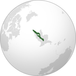
 Location of Kahneska (dark green) | |||||||||||||
| Capital | Ahtawenhne | ||||||||||||
| Largest city | Nokosvyi | ||||||||||||
| Official languages | Gawonihisdi Kanien'kéha Iyuha Ínts’o Goyogohó twayaʔ | ||||||||||||
| Recognised regional languages | Helmenska Hyacinthean Fallish Waldish Helmish | ||||||||||||
| Ethnic groups (2022) | 26.7% Ama 17.7% Kanonhwarón 13.9% Škaŋkála 11.2% Wazha'ze 8.3% Gweñskë 6.6% Nihsëh 14.3% Elian/Free Stater 1.3% Other | ||||||||||||
| Religion (2022) | 58.1% Gregorianism 13.6% no religion 25.6% folk religion 2.7% other | ||||||||||||
| Demonym(s) | Kahneskan | ||||||||||||
| Government | Federal directorial parliamentary republic | ||||||||||||
| Ama Edohi | |||||||||||||
| Tekonwí Hill | |||||||||||||
| Waŋblí Ayútepiwiŋ | |||||||||||||
| Legislature | Kahneskan Parliament | ||||||||||||
| History | |||||||||||||
| Area | |||||||||||||
• Total | 448,454.7 km2 (173,149.3 sq mi) | ||||||||||||
• Water (%) | 9.53 | ||||||||||||
| Population | |||||||||||||
• 2022 estimate | |||||||||||||
• Density | 35.76/km2 (92.6/sq mi) | ||||||||||||
| GDP (PPP) | 2022 estimate | ||||||||||||
• Total | |||||||||||||
• Per capita | |||||||||||||
| GDP (nominal) | 2022 estimate | ||||||||||||
• Total | |||||||||||||
• Per capita | |||||||||||||
| Gini (2022) | low | ||||||||||||
| HDI (2022) | very high | ||||||||||||
| Currency | Uwoyí (Ꞹ), BSG) | ||||||||||||
| Time zone | UTC+4 (Kahneska Standard Time, KST) | ||||||||||||
| Date format | dd-mm-yyyy | ||||||||||||
| Driving side | right | ||||||||||||
| Calling code | +99 | ||||||||||||
| Internet TLD | .kn | ||||||||||||
Kahneska, officially the Federated States of Kahneska[a], is a sovereign state in Elia Borealis. It is bordered by the Free States to the west, X to the northeast, Josephinia and Siskiyou to the east, and Eskland to the southeast. It is hydrogepgraphically bordered to the north by the Glacian Ocean and to the northwest by the North Medan Ocean. With an estimated population of around 16 million people, it ranks as the second-most populous nation in Elia Borealis and is the most ethno-linguistically diverse. Kahneska's multiethnic heritage includes a mixture of indigenous Elian peoples and Calesian settler populations. Its capital is Ahtawenhne, while its largest city is Nokosvyi.
The territory of modern-day Kahneska hosted what was essentially the heartland of the Elian civilization as one of the world's cradles of civilization, which extended across Elia Borealis; until the 16th century, after the disastrous Catabolic Crisis and Calesian colonization significantly shrunk the amount of land ruled over by the indigenous Elian tribes. Early forms of confederation persisted amongst the inland regions with the X, where they often resisted settler colonialism, until the early 18th century, with a brief resurgence again in the latter part of the century before being annexed into the Grand Federation in 1790. In the aftermath of a civil conflict alongside many decades of indigenous resistance, the country in its current borders gained its independence in 1895, taking on its current form of government in 1899. Since then, it has had some level of instability and internal strife, including internal tribal struggles and issues with the settler populations that still inhabit the country.
Known as the "land of lakes and mountains", Kahneska's abundance of biodiverse and unique ecosystems also includes many endemic species and landscapes and contributes to tourism and mineral exports as some of the primary means of development for the fledging economy. However, despite being rich in natural resources, Kahneska is a developing country and an estimated 22% of the population lives in poverty, nearly double that of its neighbors. Other societal issues facing the country include gun crime, corruption, and civil instability.
Kaneska is a federal directorial parliamentary republic, headed by a President chairing the Executive Council. It is a member state of the United Congress, Organization of Elian States, Elian Free Trade Agreement, Non-Aligned Movement, and X.
Etymology
Etymologically, the name "Kahneska" is believed to have been derived from the Kanien'kéha language of the Kanonhwarón people. Specifically, it comes from the early word of "Kahneskahará", meaning "the place of the longhouse by the waters." It was a name notably used by many of the tribes in the modern-day area of Kahneska to signify a sense of unity and communal or communitarian living. However, with the arrival of Calesian explores and settlers, the name was often shortened or misapplied to other tribes. This led to many actually adopting the name over time, especially as it was applied during colonial-era administrations.
An alternative explanation for the name is the Gawonihisdi word ᎧᏁᏍᎦ, or Kvnesga, which referred to northern tribes as a "land of white" or "pure land," though this phrasing and the periods and geography of Calesian contact suggest the former etymology to be most likely, especially as the Kanonhwarón tended to be more receptive and diplomatic towards Calesian explorers and settlers.
History
Prehistory
Around 10,000 BCE, some of the first Homo sapiens began to migrate westwards along a land bridge between Galania and Elia Australis. This era was marked too by a period of heightened global glaciation, cooler temperatures, and lower sea levels. Upon settling in Elia Australis for a couple thousand years, early humans began migrating northwards again.
As a result of early migration northwards from Elia Australis, the earliest human habitation of Elia Borealis began to occur around 3,000 to 2,500 BCE. The presence of humans in the region is evidenced by the existence of skeletal remains and stone tools found in the region. In particular, early agricultural practices, likely carried over from Elia Australis, are prevalent throughout the duration of human habitation in the region; however, the majority of these cultures remained fairly nomadic or hunter-gatherer in nature.
These lifestyles were supported by the region's relatively untouched natural resources, like the abundance of megafauna, especially white-tailed deer and bison. Many abundant and edible plant species also inhabited the region, allowing for the hunter-gatherer lifestyle to persist for some lengthy duration of time.
Forest period
The Forest period of Elia Borealis began around the turn of the first millennium, or 0-200 CE, where agricultural practices became more widespread, and the nomadic and hunter-gatherer ways of life began to decline. It was also marked by the development of mound-building cultures, many of which settled down and started constructing small settlements centered around central mound structures. Many tribes began to develop agrarian and pastoralist practices in lieu of the aforementioned ones, and agricultural practices continued to develop and become widespread.
Many folk religions and mythologies, like those of the Tsul 'Kalu and the moon-eyed people, and religions of the likes of the Kitu'wa among the Ama tribes and the Wočhékiye for the Škaŋkála tribal group. Many of the indigenous spiritual beliefs and religions continue to influence modern traditionalist movements within the country.
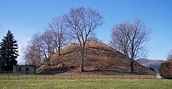
Some of the more notable artifacts of the era include many mound structures, like the infamous Tsali mound in the Kitara province, belonging to the North Ama tribe. Further north in Olíhwake province there have been numerous findings of whale bone carvings and arrowheads, as well as carved and necklaced seashells. To the east, in regions like Itókaǧa and Asgaí provinces, some stone structures and cave dwellings have been found and dated to this period.
The decline of the Forest period came around 600 CE, where many cultures became largely sedentary, and advancements began to plateau for some time. Many archeological sites throughout the country also show how cultural practices and building styles were different between coastal, mountain, and planal parts of the continent. There is also debate among archeologists over the exact start date of the Forest period, with some arguing that it should be around the earliest creation of pre-contact mound structures, around 400 BCE, making the entire Forest period last an entire millennium. Artifacts uncovered in these mounds also give evidence of village societies with a tribal trade system culture that crafted cold-worked copper pieces.
Denvsoqua period
After the Forest period of 200-600 CE came the Denvsoqua period, lasting from 800-1400 CE. The Denvsoqua period saw further advances in agriculture, the cultivation of maize, and the foundation of more complex chiefdoms, often consisting of several villages and concentrated populations. Much of the archeological findings today originate from this era, as it also saw unique cultural advances in pottery making, storytelling, and the use of sculptures and effigies, as well as unique burial practices.
Many modern placenames are carryovers of the linguistic developments and sedentism that occurred in this era, such as Kitara province, whose name no longer matches the spelling/phonology of the Onkwehónte language of modern Gawonihisdi.
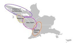
Notable events during this period include the "Great Peace Law" (Kanien'kéha: Kaianere’kó:wa) among the northern Onkwehónte tribes (the Kanonhwarón, Gweñskë, and Nihsëh). It is believed to have occurred around c. 1190, when the Kanonhwarón tribal chief Kawehnó ("He is a leader") met with the Gweñskë chief Gëdwá ("He who speaks well") and the female Nihsëh chief Yakotsháhkwa ("She speaks truth"). At this supposed meeting, the three chiefs, led by Kawehnó, formed the basis of the Onkwehónte Confederation, the first true, albeit loose, polity of the region. The laws, despite being largely oral, were also written down in pictographic form on wampum belts and preserved amongst each specific tribe.
To the south, the various tribes of the Ama peoples inhabited much of the modern-day central and mountainous parts of the Free States, as well as much of their current homelands. Here they saw the emergence of ideas that have transferred over into the modern day, like that of Gadugi (Gawonihisdi: ᎦᏚᎩ), or "cooperative labor". Their contact with the northern Onkwehónte tribes also inspired various similar forms of proto-democratic governance in the regions controlled by Ama tribes, but it also later led to a split around the year 1300, where the traditional leaders, Ani-kutani (ᎠᏂᎫᏔᏂ) were overthrown in the northern tribes due to abuses of the people. This led to a period of over two centuries of warfare between the northern and southern Ama tribes, known as the Watsi Sagoyai Unolehvwi (ᏩᏥ ᏌᏉᏯ ᎤᏃᏴᏫ), or "Warring Nations Era," which lasted until around the 1550s, well after Calesian contact.
Furthermore, the Denvsoqua period saw much of the sedentarization of the indigenous groups as they appeared upon arrival by Calesian explorers. But the Catabolic Crisis brought about the end of the Denvsoqua, as the cold temperatures and near instantaneous climate change saw the Denvsoqua way of life torn asunder. The impacts it had on crops forced many groups back into a hunter-gatherer way of life, it also saw the migration of much of the megafauna, forcing some settlements to be abandoned. These changes left behind a plethora of archeological sites, but also saw a significant reduction in the population of Elia Borealis as a whole.
Calesian colonization
The first contact with Calesian explorers came in 1482 when they first arrived in Elia Borealis in search of new trade routes to western Abaria in the aftermath of the collapse of the Pax Artuchidia and the Artuchid Empire. While no permanent settlement was made for some time, new diseases began to spread slowly through the western coastal regions of Elia Borealis, and by the time of the first permanent Fallish settlement in 1492, much of the coastal regions had been deserted, with the indigenous peoples believing the Catabolic Crisis and subsequent spell of diseases like smallpox to be a bad omen. This demographic shift continued to be exacerbated by a growing presence of settlements along the western coast, and skirmishes with settler populations.
With the signing of the Fallish Imperial Declaration in 1504, and the subsequent establishment of the Fallish Empire, foreign colonies began lining the coast, and explorers began having regular contact with the inland tribes. Fur trappers, hunters, and prospectors were all among the earliest foreign settlers to settle within the inland regions. Additionally, the continual discoveries of gold and other resources in western Elia Borealis led more settlers and colonies westward. This laid the foundations for the modern-day neighbors of Kahneska, like Siskiyou and Josephinia. TBD
Elian rule
Modern history
Geography
Government and politics
Legislative branch
Executive branch
Judicial branch
Tribal branch
Military
Foreign relations
Administrative divisions
Economy
Demographics
Culture
Music
Dance
Literature
Cuisine
Sports
Media
Notes
- a.^ Gawonihisdi: ᏗᎦᎢᏍᏗ ᎤᏪᏘᏍᎬ ᎠᏧᏣᎳᏅᏍᎩ; Kanien'kéha: Kahneska Nitonkwa'tsheró Ohskenón; Iyuha: Kahneska Očháŋžapi Othúwahe; Ínts’o: 𐓄𐓐𐒰𐒼𐒻 𐓊𐒻𐓓𐒻 𐓊𐒰𐒼𐒻 𐒼𐒰͘𐓁𐒷𐓆𐒼𐒰; Goyogohó: Kahneska Gëjohsë önyö:’gwah; twayaʔ: Kahneska Tetwatatyahthónt


