Isla Ima
Republic of Imanna | |
|---|---|
|
Flag | |
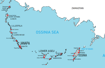
 Map of the Northern Cantalle Islands | |
| Capital | Isla Ima |
| Demonym(s) | Imannan |
| Government | |
| Joseph Tacaba | |
| Area | |
• | 281 km2 (108 sq mi) |
| Population | |
• 2022 estimate | 207,000 |
| Date format | mm-dd-yyyy |
The Republic of Imanna, commonly known as Isla Ima or Imanna, is an island nation in the Northern Cantalle Islands in the Cantalle Ocean, sitting west of the Laurichesse Islands of Asuch and Perot. It is the second-smallest nation in the NCI archipelago by both area and population, the only smaller being Arrey. Isla Ima has a populaiton of around 207,000, most concentrated in the island's main city.
Isla Ima was settled by Quetanan shippers in 1677, who utilized slave labor for sugar and tobacco plantations on the island. The island transferred between control of the Quetanans and Skithans in 1788, back to Quetana in 1849, before gaining independence in 1911 when Quetana withdrew its colonial forces. The island has gone through a series of coups and periods of sectarian unrest, but has generally remained a stable state. The island's perimeter is roughly 87 km (54 mi) and its area 281 km2 (108 sq mi), and is divided into 11 administrative districts. The economy is mainly reliant on tourism, with the agricultural sector serving the domestic market.

