Camia
Republic of Camia Camia, 昭昌 | |
|---|---|
Motto: Vi(s) et voluntas/tes (by) strength and will | |
Anthem: Blood of our forefathers | |
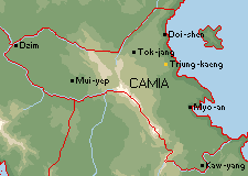
 Map of Camia | |
| Capital | Cooking / Tiung-kyaeng (中京) |
| Official languages | Tyrannian, Shinasthana |
| Demonym(s) | Camian |
| Government | Unitary presidential republic |
• President | A.B. |
• Vice President | C.D. |
| Legislature | Parliament |
| High Council | |
| House of Representatives | |
| Independence from Themiclesia (edict passed on Sept. 29, 1703) | |
• Din dynasty established | Jan. 5, 1701 |
• First Republic established | Oct. 3, 1757 |
• Second Republic established | Mar. 21, 1823 |
• Din dynasty restored | Aug. 12, 1834 |
• Second Republic restored | Feb. 29, 1859 |
• Third Republic established | Feb. 5, 1893 |
| Population | |
• 2017 estimate | 19,254,200 (31) |
• Density | 69/km2 (178.7/sq mi) |
| GDP (PPP) | 2018 estimate |
• Total | $758,394,000,000 (36) |
• Per capita | $39,894 (17) |
| GDP (nominal) | 2018 estimate |
• Total | $690,188,000,000 (31) |
• Per capita | $36,315 (21) |
| Currency | hyan (緍) (HYA) |
| Time zone | UTC+2 |
| Date format | yyyy-mm-dd |
| Driving side | right |
| Calling code | +3 |
| Internet TLD | .cm |
The Republic of Camia is a country on the western coast of the Halu'an Sea, in the western part of the continent Hemithea. It borders Suularko to the north and Novnoebiya to the west. The county has 19.25 million inhabitants, and its capital city, Tiung-kyaeng, is situated to the northeast.
Name
The capital city's name, Cooking, is an imprecise transliteration of the Themiclesian name Tiung-kyaeng (中京, lit. "middle capital"). Tiung-kyaeng was originally named Yen-k'ang (延康, lit. "prolong prosperity") under the Din Dynasty and the First Republic. It is a popular myth that the original name references the name of the Themiclesian capital Kien-k'ang (建康, lit. "establish properity"), signifying a cultural tie with Themiclesia, the metrepole of Camia during the colonial period. But Yen-k'ang, long before being capital city of Camia, already bore that name, so it is unlikely this name was chosen to depict Camia as a successor to Themiclesia. Nevertheless, this myth was taken as fact during the Revolution of 1799 and changed to Tiung-kyaeng, to sever the semantic connection to Themiclesia.
History
Prehistory and early trade routes
Themiclesian administration
Under the direction of Emperor Tjaw-mjen (孟昭文帝, mrangs-tjaw-mjen-tis) of the Meng Dynasty (孟, 543–752), Themiclesia began to fortify the trade routes its merchants treaded, establishing several fortifications along them. During this period, these fortifications did not, generally, attempt or imply control over territory beyond the routes. In the following Dziai Dynasty (齊, 752–1020), these fortifications were used to establish military dominance over aboriginal societies in their vicinities; in 815, a marshalling of all fortresses' soldiers in one expedition overwhelmed the aboriginal coalition decisively at modern-day Keuruu, which affirmed Themiclesia's political dominance over the continent. In reference to contrasting architecture, they named Themiclesians as the "People of the Wide House". Later in the Dziai Dynasty, the continent was split into two regions; the area east of the Camian Mountains was called the Left, and west of it, the Right. In contrast with the Meng policy of appeasement and gift-exchanges, the Dziai regarded any non-submitting aboriginals as non-human and permitted its soldiers to do whatever they liked with them; since these soldiers were mostly violent (or even organized) criminals, disputes regularly occurred between them, merchants, and aboriginals.
The aggressive policy and poor conduct of Themiclesian soldiers encouraged alliances to form between aboriginal societies and the emergent Hallian settlers, who were more willing to interact as peers and with less coercion.