Emnia
This article is incomplete because it is pending further input from participants, or it is a work-in-progress by one author. Please comment on this article's talk page to share your input, comments and questions. Note: To contribute to this article, you may need to seek help from the author(s) of this page. |
Kingdom of Emnia Miomhláiche t-Eamhna | |
|---|---|
|
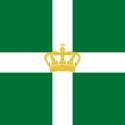
Flag | |
Motto: Flōrēbō Quōcumque Ferar "I will flourish wherever I am brought" | |
 | |
| Capital | Cártuaist |
| Largest city | Baight Chnaghn |
| Official languages | Emnian |
National minority languages | Eastonian |
| Demonym(s) | Emnian |
| Government | Unitary parliamentary constitutional monarchy |
• Monarch | Príoma II |
| Ríobhca beáth t-Annraoi | |
| Legislature | Sainidinn |
| Establishment | |
• Unification | 872 |
• Union with Southerland | 1397 |
• War of Independence | 1812–1814 |
• Constitution Adopted | 1814 |
| Area | |
• Total | 385,207 km2 (148,729 sq mi) |
• Water (%) | 5.2 |
| Population | |
• 2021 estimate | 5,402,171 |
• Density | 14.0/km2 (36.3/sq mi) |
| Gini | 25.4 low |
| HDI | very high |
| Driving side | left |
| Internet TLD | .emn |
Emnia (Emnian: Eamhna /avˠɾˠə/) officially the Kingdom of Emnia (Emnian: Miomhláiche t-Eamhna /mʲʊvˠlaːçə tʲ‿avˠɾˠə/), is the northernmost sovereign state in Calatania. Emnia's capital is Cártuaist, and its two largest metropolitan areas are Baight Chnaghn and Seolmhac.
Emnia has a total area of 385,207 square kilometres (148,729 sq mi) and had a population of 5,385,300 in 2020. The country shares a long southern border with Southerland and is bounded by the Endless Mountains to the north and east and the Great Sea to the west. Emnia is situated on both sides of the River Thoibhronn which flows from the northeast of the country through its heartlands and out into the sea through the Thoibhronn Delta. The maritime influence dominates Emnia's climate, with mild lowland temperatures along the river valley and seacoast. Even the eastern interior of the country, while colder, is milder than areas elsewhere in the world on such northerly latitudes. High rainfall and snowfall are commonplace.
Príoma II is the current Queen of Emnia. Ríobhca beáth t-Annraoi has been prime minister since 2021, replacing Mairéad beáth Lorcán. As a unitary sovereign state with a constitutional monarchy, Emnia divides state power between the Parliament, the Cabinet, and the Supreme Court, as determined by the 1814 Constitution. The Kingdom was established in 872 as a merger of several petty kingdoms and tribal realms which had existed largely unchanged since the bronze age. From 1397 to 1814, Emnia was in personal union with the Kingdom of Southerland until the Emnian War of Independence. Emnia was neutral in the first world war, and remained so until the second world war when the country was invaded and occupied by Austrasia until the end of the war.
Emnia has both administrative and political subdivisions on two levels: prefectures (míogalaimh, sing. míogall) and municipalities (cairdheoth, sing. cairdhe). The Eastonian people have a certain amount of self-determination and influence over their tradtional territories through the Eastonian Parliament and the Far East Act. Emnia maintains close ties with both the Calatanian Union and Westralia, and is a founding member of the Global Forum, Free Trade Association, and the Boreal Council.
Emnia maintains the Boreal Welfare Model with universal healthcare and comprehensive social security infrastructure, and its values are rooted in egalitarian ideals. The Emnian state has large ownership positions in industrial sectors, having extensive reserves of petroleum, natural gas, minerals, lumber, seafood, and fresh water. The petrochemical industry accounts for around a quarter of the country's gross domestic product (GDP).
Although the majority of the population is ethnic Emnian, in the 21st century, immigration has accounted for more than half of population growth; as of 2021, the largest minority groups in the country are the descendants of Austrasian, Westralian, and Sudric immigrants.
History
Prehistory

The first inhabitants of modern Emnia were the White Rock Culture (11th to 10th millennia BCE), which was a late Upper Paleolithic culture during the Younger Dryas, the last period of cold at the end of the most recent period of glaciation. The culture is named for the village of White Rock in northwestern Southerland, where wooden arrow shafts and clubs have been excavated. The earliest traces of human occupation lie along the delta coast, which was first exposed by the melting ice sheets between 11,000 and 8,000 BCE. The oldest stone tools recovered date back to between 9,500 and 6,000 BCE, and were discovered near Lake Cheirbheoth in the east and Caoislíonn in the west. Those findings were initially described as two separate material cultures (one inland culture and one along the coast), but this was later revealed by more extensive findings to be attributable to being different types of tools, rather than tools belonging to different material cultures.
Dwelling sites dating from approximately 5,000 BCE provide a clearer image of the life of those hunting and fishing peoples. Their tools vary in shape and size, and are made from various types of stone; those of later periods are exceptionally skillfully made. Rock carvings (i.e. petroglyphs) have been found, usually near hunting or fishing grounds. They represent game such as deer, reindeer, elk, bear, fowl, seals, whales, and fishes (especially salmon and halibut), all of which were vitally important to their way of life.
