Monbec: Difference between revisions
No edit summary |
No edit summary |
||
| Line 2: | Line 2: | ||
{{Infobox settlement | {{Infobox settlement | ||
|name = Monbec | |name = Monbec | ||
|native_name = | |native_name = | ||
|native_name_lang = Gaullican | |native_name_lang = Gaullican | ||
|settlement_type = Province | |settlement_type = Province | ||
Revision as of 17:05, 14 October 2021
This article is incomplete because it is pending further input from participants, or it is a work-in-progress by one author. Please comment on this article's talk page to share your input, comments and questions. Note: To contribute to this article, you may need to seek help from the author(s) of this page. |
Monbec | |
|---|---|
Province | |
| Motto(s): Concordia Salus (Solarian) "Well-being through harmony" | |
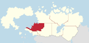
 Map of Cassier with Monbec in red | |
| Country | |
| Capital | Monbec City |
| Largest city | Sainte-Marie |
| Largest metro | Greater Sainte-Marie |
| Confederation | 1 July, 1757 |
| Government | |
| • Body | Government of Monbec |
| • Premier | [name] |
| • Governor | [name] |
| Area | |
| • Total | 525,468.16 km2 (202,884.39 sq mi) |
| • Rank | 6th |
| Population (2018) | |
| • Total | 6,454,004 |
| • Density | 18.07/km2 (46.8/sq mi) |
| Time zone | UTC+9 (Western) |
| Abbreviation | MC |
| Prefix | H, J, K |
| ISO 3166 code | CA-MC |
| Rankings include all provinces and territories | |
Monbec is a province in western Cassier, and its third largest by population. Monbec borders Dumont Bay to the west, the provinces of Chicadia, New Sylvagne to the south, the province of Breloux to the east, and the territory of Borealia_(TERR) to the north. The capital of Monbec is Monbec City, while its most populous city is Sainte-Marie. It is the seventh largest province, covering an area of 525,468.16 squuare kilometres and is the third largest by population, with a total of 6,454,004 inhabitants.
A variety of indigenous peoples such as the Ganonsyoni, Collinais, and Alnobaques, lived in what is now Monbec for thousands of years before the arrival of Eucleans to the region. The first Eucleans to discover to Monbec were possibly Ghailles from Caldia in the late 15th century, though this is still disputed. Rogerin Dumont was the first documented explorer to venture to the region in 1534, landing near the mouth of the Saint Marcus River and claiming it for Gaullica. Dumont went on to found several forts throughout what he named New Gaullica (Gaullican: Nouvelle-Gaullica), including Fort Saint Marcus at the site of what is now Monbec City in 1535. Gaullican colonists gradually began settling throughout the St. Marcus River until the region became part of the St. Marcus Colony (1605-1671) and then Lower Cassier (1671-1757). Lower Cassier was one of the five provinces of New Gaullica to confederate into the Domain of Cassier in 1757, where it became a province of the newly established dominion and the host of its capital, Sainte-Marie. Lower Cassier was highly influencial on the cultural, economic, and political development of Cassier. In 1905 on the anniversary of the founding of Monbec City, the province changed its name to Monbec.
Like most of Cassier, the economy of Monbec is post-industrial and dominated by the natural resources industry. Hydroelectricity, forestry, mining, and agriculture have historically accounted for a large amount of Monbec's GDP, though new industries in the innovation and research sectors have made Monbec a leader in the tech world.
Etymology
Monbec is named after Jean-Martin de Monbec, a Gaullican courtier and first viceroy of the Saint Marcus colony. Jean-Martin de Monbec was responsible for founding Cassier's first city, originally named "Louisbourg" for the reigning Gaullican monarch, King Louis IV, and is widely considered to be one of the most influencial figures in Cassien history. The city was later renamed to "Monbec" in 1676.
On June 5th, 1905, to commemorate the 300th anniversary founding of Monbec City, the General Assembly of Cassier passed an act that renamed the province of Lower Cassier to Monbec.
