Amarillo
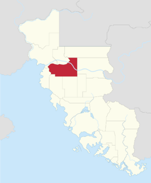
Amarillo is a state located in the Northern Region of the United Republic of Aurelia, sharing borders with New Vega to the north, Davis to the northeast, Anderson and Brooks to the east, Shanks and Stewart to the south, Nimoy to the west and Nova Ibericá to the northwest. The state is characterized by the Angles Mountains, and is part ot the Angles Mountain Range, which spans from the southwest, and into the east. The mountain range features the dormant volcano, St. Cristobal. Amarillo boasts a diverse range of geographical features, including the Tonane Valley, carved out by the Tonane River, and a section of the Hovakí Desert, situated within the Aurelian Wastes.
As of the latest United Republic Census and Statistics Bureau report in 2020, Amarillo's estimated population stands at 624,259 residents, ranking it as the 12th most populous state in the United Republic of Aurelia. The state exhibits a youthful demographic, drawn in part by its progressive stance on social issues and its robust education system, exemplified by the United Republic Air and Space Academy. The Tamarind, Hovakí and Tesoro peoples still inhabit and call their ancestral lands within Amarillo home.
Also known as the the Centennial State, Amarillo was admitted to the Republic on March 20th, 1877, the centennial anniversary of the Declaration of Independence. Settlers from Iverica settled the area in the mid-1600s. In 1834, the state experienced the Angles Gold Rush, seeing an influx of settlers ariving from the southern parts of the United Republic. It also played a crucial role in the formation of the United Republic in 1776, hosting the significant signing of the Covenant of Unity between the Settlers of the United Republic, and the Native Peoples of Aurelia.
The economy is anchored by the Federal Government, primarily through the United Republic Armed Forces and the United Republic Air and Space Academy. A budding techscene with companies such as Ekko and Redlingo. Further more, the state still has several mining operations that are ongoing, such as lithium, uranium and gold mining. As well as some light agricultural activities. Tourism is also a vital part of the state's economy, driven by the state's abundant outdoor recreational activities.
Amarillo has a diverse range of climate zones, but can be divided into three main zones; the northeast is dominated by a hot semi-arid climate zone, a band spanning from the northern banks of the tonane river, to the northern edge of the Angles mountain range, is dominate by a cold semi-arid climate zone. and the south is dominated by a Hot summer humid continental climate zone. The state boasts a divese variety of flora and fauna, including the Amarilli Condor, Lilac-crowned parrot, Mule deer, Pronghorns, and various species of Cacti and Juniper trees.
The state fosters a thriving craft beer culture and industry, as well as several outdoors apparel brands, reflective of Amarillo's emphasis on outdoor activities and wellness.
Etymology
The name "Amarillo" is derived from the Iverican language, with it's roots in the Iverican word for yellow. The Iverican explorers and settlers who ventured into the region were struck by the vibrant and golden hues of the landscape, particularly during sunrise and sunset, giving rise to the name "Amarillo" to describe the stunning yellow and golden shades that enveloped the land. Over time, the name became synonymous with the region's natural beauty, warmth, and the rich cultural heritage of the area, eventually leading to its adoption as the name for the state in 1877.
History
Geography
Demographics
Governance
Economy
Healthcare
Education
Infrastructure
Culture
 | |
 | |
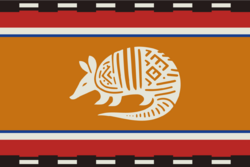
| Nickname | The Armadillo State |
|---|---|
| Motto | Moon, Star, and the Sun |
| Poem | Amarillo's Golden Horizons |
| Slogan | Where Peaks Meet Plains |
| Anthem | Amarillo's High Serenade |
| Living insignia | |
| Amphibian | Tonane chirping frog |
| Bird | Greater roadrunner |
| Butterfly | Southern Empress Butterfly |
| Cactus | Stenocereus thurberi |
| Fish | Amarillo River redband trout |
| Flower | Firewheel flower |
| Grass | Buffalo grass |
| Mammal | Nine-banded armadillo |
| Reptile | Great Basin collared lizard |
| Tree | Juniper |
| Vegetable | Sweet potato |
| Inanimate insignia | |
| Beverage | Iced tea |
| Confectionery | Bonuelo |
| Costume | Northern wear |
| Dish | Chili con carne |
| Firearm | Tamurillo Model 1880 |
| Folk dance | Square dance |
| Fossil | Ammonite fossil |
| Gemstone | Turquoise |
| Instrument | Acoustic-electric guitar |
| Lake | Lake Amarillo |
| Mineral | Fluorite |
| Rock | Sandstone |
| Ship | URS Amarillo |
| Soil | Red clay soil |
| Sport | Summer: Rodeo Winter: Snowboarding/Skiing |
| Toy | Rocking horse |


