Byramir
Jump to navigation
Jump to search
Byramir
Lourenço Marques (official name until 1966) | |
|---|---|
City and Province | |
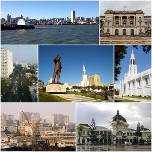
 Clockwise, from top: Byramir skyline, Byramir City Hall, Our Lady of the Immaculate Conception Cathedral, Byramir Railway Station, Port of Byramir, Avenida 24 de Julho, and the Amora Echel Statue in Independence Square | |
| Country | Peoratia |
| Area | |
| • City and Province | 347.69 km2 (134.24 sq mi) |
| Elevation | 47 m (154 ft) |
| Population (2017 census) | |
| • City and Province | 1,088,449 |
| • Density | 3,100/km2 (8,100/sq mi) |
| • Metro | 1,766,823 |
| Time zone | UTC+2 |
| Postal code | 0101-XX, 0102-XX, 0103-XX, 0104-XX, 0105-XX, 0106-XX, 0107-XX |
| Area Code & Prefix | (+258) 21-XX-XX-XX |
| ISO 3166 code | BM |
Byramir is the largest city in Peoratia, situated along the northern coast of the country on the Albarine Sea. Byramir has a population of 1,088,449 (as of 2017) distributed over a land area of 347.69 km2 (134 sq mi). The metropolitan area includes the neighbouring city of Tatola, and has a total population of 2,717,437. Byramir is a port city, with an economy centered on commerce. It is also noted for its vibrant cultural scene and distinctive, eclectic architecture.