Vermand
This article is incomplete because it is pending further input from participants, or it is a work-in-progress by one author. Please comment on this article's talk page to share your input, comments and questions. Note: To contribute to this article, you may need to seek help from the author(s) of this page. |
Kingdom of Vermand
2 other official names
| |||||
|---|---|---|---|---|---|
 Flag
 Coat of Arms
| |||||
Motto:
| |||||
| Anthem: "Le Chant des Vermandois" | |||||
 Vermand Parthenia | |||||
| Capital | Lutécie | ||||
| Official languages | Vermandois Gascon | ||||
| Recognised regional languages | Compiègnois | ||||
| Ethnic groups | See Ethnicity | ||||
| Demonym(s) | Vermandois | ||||
| Government | Unitary parliamentary constitutional monarchy | ||||
• King | Jean V | ||||
• Prime Minister | Nathalie Perrault | ||||
• President of the Senate | Bruno Legrand | ||||
• President of the National Assembly | Olivier Fouquet | ||||
| Legislature | Parliament of Vermand | ||||
| Senate | |||||
| National Assembly | |||||
| Population | |||||
• 2022 estimate | |||||
• 2018 census | 67,841,235 | ||||
• Density | 117.1/km2 (303.3/sq mi) | ||||
| GDP (PPP) | 2022 estimate | ||||
• Total | |||||
• Per capita | $47,952 | ||||
| HDI | 0.903 very high | ||||
| Currency | Franc (VDF) | ||||
| Date format | dd.mm.yyyy | ||||
| Driving side | right | ||||
| Calling code | +078 | ||||
| ISO 3166 code | .VR | ||||
Vermand (Vermandois: Vermand) officially the Kingdom of Vermand (Vermandois: Royaume de Vermand) is a country located on the Anglish Peninsula in Eastern Parthenia. It is bordered by Angland and Neith to the east, Laagland to the west and the Aurean Sea to the south.
Inhabited by early humans since the Paleolithic, the land was settled in the Iron Age by a Celtic tribe known as the Volcens. The area was annexed by the Remillians as early as 61 BC, which lead to a unique culture and language influenced by both Latin and Volcennic, this paved way for the evolution of the Vermandois language. Upon the collapse of the Remillian Empire, the Eisen Vermans formed the First Kingdom of the Vermans. After the Treaty of Vérodonne in 843, East Vermandia became the predecessor of Vermand, and West Vermandia became that of Laagland and Livania. Vermandia was among the last surviving Livanic kingdoms from the Migration Period era before its partition in 843. This was succeeded by Charles the Great's Carolean Empire. During the Childerian and Carolean dynasties the Vermandish realm was one large polity subdivided into several smaller kingdoms, often effectively independent. It covered much of Eastern Parthenia but later succumbed to the pressures of internal civil wars combined with external invasions: Wittekings from the north and Tarandran Tribes from the south. During the High Middle Ages Vermand existed as a decentralised kingdom. During the Late Middle Ages, rivalry between the Robertian Dynasty, rulers of the Kingdom of Vermand and the House of Orange, who ruled their fiefdom and holdings in Laagland as well as regions in Vermand and the Kingdom of Angland as part of their competing empire, resulted in many armed struggles. The most notorious of them all are the series of conflicts known as the Endless War. Vermand in the early modern era was increasingly centralised; the Vermandois language began to displace other languages from official use, and various monarchs expanded into absolute power in an administrative system (the Vieux Système)
Etymology
History
Prehistory
Geography
Vermand is located in Eastern Parthenia, and is bordered by the Aurean Sea to the south, and by several neighboring countries to the east and west. The landscape of Vermand is diverse, with a combination of coastal plains, rolling hills, and rugged mountains.
To the west of Vermand lies the rugged and mountainous region of the Bazeilles, which is known for its dense forests, deep valleys, and natural beauty. The Bazeilles is also home to several important rivers, including the Meuse and the Sambre.
In central Vermand lies the vast Napeli Sea, a freshwater sea that the country bases much of it's culture around, taking up a large part of the countries land area. The basin to the south-east, characterized by fertile farmland and gently rolling hills, and is crisscrossed by several major rivers, including the Seine and the Loire. In the Lutecian Basin, the capital city of Lutécie is located.
To the east of the Napeli Sea lies the majestic Obivan highland range, which contains the highest points in the country. The Obivan is known for its rugged terrain, deep gorges, and ancient volcanoes.

The famous Remillian theatre in Lugodonne

The streets of Lugodonne
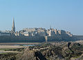
The walled city of Sainte Madeleine
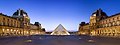
The Louvre, Lutécie.


Biodiversity
Climate
Politics and Government


Foreign Relations
Military
Administrative Divisions
Law
Law Enforcement
Economy
Primary sector
Secondary sector
Tertiary sector
Quarternary sector
Energy
Natural resources
Demographics
Urbanization
Immigration
Religion
Languages
Education
Healthcare
Culture
See Also
References