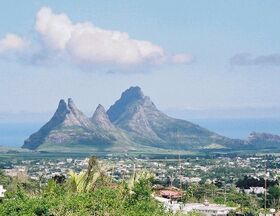
Vekh Süilya
| Vekh Süilya | |
|---|---|
 Vekh Süilya (centre of image) and the rest of the Ritan Süilya, seen from the south | |
| Highest point | |
| Elevation | 665 m (2,182 ft) |
| Prominence | 665 m (2,182 ft) |
| Geography | |
| Location | southern Morikz, Trellin |
| Parent range | Ritan Süilya |
Vekh Süilya is a mountain with volcanic origins on the south coast of Morikz. Its sheer-sided summit is the highest on the island and stands 665 m (2,182 ft) above sea level. The mountain lends its name to the Ritan Süilya, a cluster of three peaks north of the town of Süilaq. It is one of the best-known landmarks on the island and visible from high points across Morikz and on Arnyü's Finger.
Ritan Süilya
The Ritan Süilya was formed during a frenzy of volcanic activity about 10 million years ago. Extensive flows of lava formed a plateau in the centre of the island and two main mountain groups at opposite ends of the island. The Akar Süilya is the smaller, but taller and more visibly striking, of these two groups.
Three mountains make up the range, which arcs from south to north with a plateau on the east and a much lower vale on the western side, forming the bowl. The southernmost mountain, Kinten ("The Teeth"), is split into three peaks: an unnamed southern top (594 m (1,949 ft)) and two sharp peaks: Kintetsa ("Black Tooth") and Kintkuma ("White Tooth") of 644 m (2,113 ft) and 635 m (2,083 ft), separated by a deep cleft. A slender ridge connects Kinten to Laditalan ("The High Hat" in the Morikzan dialect of Trellinese), which reaches a height of 601 m (1,972 ft).
Vekh Süilya is the northernmost of the range, defined by a long and rough ridge that isolates it from Kinten and Laditalan. Deep crevasses make this ridge a treacherous approach, and the mountain then rises sharply towards its summit. A lower, more accessible spur on the northern end caps out at 605 m (1,985 ft) and is the last high point of the range.