Morikz
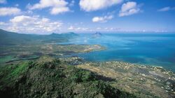
 North coast of Morikz | |
 | |
| Geography | |
|---|---|
| Location | Western Sea of Velar |
| Area | 4,037.88 km2 (1,559.03 sq mi) |
| Highest elevation | 915 m (3,002 ft) |
| Highest point | Vekh Süilya |
| Administration | |
Trellin | |
| Provinces | Rezat Trophy Ports |
| District | Morikz |
| Capital city | Arkhal |
| Largest settlement | Vacoas (pop. 257,149) |
| Demographics | |
| Demonym | Morikzan |
| Population | 2,119,881 (2013) |
| Pop. density | 624.06 /km2 (1,616.31 /sq mi) |
| Ethnic groups | 54.1% Velaric 39.5% Trellinese 4.8% Hyseran 1.6% others |
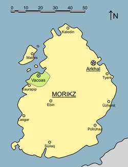
Morikz is an island in the western Sea of Velar to the north of Arnyü's Finger. With an area of roughly 4,038 square kilometres it is the fifth-largest in the Sea of Velar and the tenth-largest island in the Trellinese Empire.
Politically, the island is predominantly located within the province of Rezat – which holds over 97 percent of the island's territory – with the port city of Vacoas on its west coast belonging to the Trophy Ports. It is home to 2,119,881 people, of whom one tenth live in Vacoas, with the remainder accounting for two fifths of Rezat's entire population. The administrative seat of Rezati Morikz is at Arkhal, which was the provincial capital until 1869.
History
Middle ages
In the first half of the 1st millennium AD, Morikz was among the more powerful states in the Sea of Velar, existing under its own prince. Its merchants were prominent in several major ports including Durats, where the Morikzan quarter was one of the largest. The death of Prince Garún in 512, however, left the country without an heir, and several claimants - not all consanguineous - vied for the crown. Subsequent generations led to further fracturing, such that when a Trellinese invasion force under general Marno Arguz arrived in the 750s there were more than twenty separate lordships on the island, of which seventeen claimed the throne for themselves. Arguz conquered the town of Kaurapip and used the stone of its fortifications to build a new port on the nearby beach of Vakhoaz (modern-day Vacoas). With substantial investment from the Sidereal Crown, this port quickly became an important stop on the major west Velaran trade routes as Trellinese troops subjugated the rest of the island.

Vacoas' history dominated Morikzan politics for several centuries after its founding, as it proved impossible to find a generally acceptable claimant to the title of prince and the island was simply absorbed into the Kingdom of Trellin. It nonetheless remained prosperous, as Vacoas - and the numerous other ports - continued to draw in trade, and Morikz became the staging point for waves of colonisation in Rezat to the south.
Early modern era

A major naval engagement of the War of the Velaran Succession was fought off the northern coast of the island at the Battle at Kalodin, in which the Arimathean navy destroyed a Velaran armada. Wrecking remained an important economic activity off Kalodin for several decades afterwards. The Velaran fleet had been stationed off Morikz to facilitate the ongoing Siege of Vacoas, which was abandoned after the defeat at Kalodin.
Geography

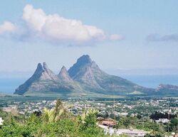
Morikz straddles the equator, the line of which runs between the towns of Vacoas and Kaurapip just north of the island's geographic centre. The topography of the island is primarily characterised by a broad central plateau, which reaches an elevation of 400 metres (1,300 ft) above sea level and slopes down to a sandy coastline which rings the island with few coastal cliffs. Morikz's volcanic origins, dated to 10 million years ago, are manifested in a ridge running around the northeast coast and in the imposing peaks of the Ritan Süilya, a cluster of extinct volcanoes centres around Vekh Süilya (which, at 665 m (2,182 ft), is the tallest peak on Morikz) on the south coast. The rural areas of the island are densely vegetated, with rainforest predominating in the north and east.
Demographics
