Western Freestate
Jump to navigation
Jump to search
Western Freestate Westerse Vrystaat (Asteriaans) | |
|---|---|
Nickname(s):
| |
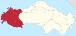
 Location of the Western Freestate in Satavia | |
| Country | Satavia |
| Before federation | Western Satavia |
| Crocodile River Colony | 12 October 1673 |
| Western Confederation | 7 December 1798 |
| Western Satavia | 1 January 1813 |
| Federation | 1 July 1838 |
| Capital | Port Arthur |
| Administration | 79 districts |
| Largest city | Victoriaburg |
| Official languages | |
| Demonym(s) |
|
| Government | |
• Governor | Christopher de Beer |
• Premier | Theo Goodwin |
| Legislature | Parliament of the Western Freestate |
| Parliament of Satavia | |
• Senate | 12 senators (of 96) |
| 37 seats (of 152) | |
| Area | |
• Total | 99,829 km2 (38,544 sq mi) (3rd) |
| Population | |
• 2022 census | 6,503,294 (2nd) |
• Density | 65.14/km2 (168.7/sq mi) (4th) |
| ISO 3166 code | SV-WF |
| Website | wf |
The Western Freestate (commonly abbreviated as WF or WV) is a province occupying the western coast of Satavia. It is bordered to the north east by Arundel and to the east by the Central Territory. With a total land area of 99,829 square kilometres it is the second largest province[N 1] and second most populous province. Its capital is Port Arthur, but its most populous city is Victoriaburg.
Notes
- ↑ The Central Territory, whilst larger, is a territory and not a province

