Kembesa: Difference between revisions
mNo edit summary |
mNo edit summary |
||
| (10 intermediate revisions by the same user not shown) | |||
| Line 3: | Line 3: | ||
{{Infobox country | {{Infobox country | ||
|conventional_long_name = Empire of Kembesa | |conventional_long_name = Empire of Kembesa | ||
|native_name = | |native_name = {{collapsible list | ||
|titlestyle = background:transparent;text-align:center;line-height:normal;font-size:84%; | |||
|title = Official names | |||
| {{Infobox|subbox=yes|bodystyle=font-size:77%;font-weight:normal; | |||
| rowclass1 = mergedrow | label1 = {{wp|Amharic language|Meharic}}: | |||
| data1 = ዬከምብሥያ ንጉሣ ነገስት መንግሥት<br>''Ye'kembesiya Negusa Negest Mengest'' | |||
| rowclass2 = mergedrow | label2 = {{wp|Tigrinya language|Degamic}}: | |||
| data2 = ሃፀያዊ ግዘአት ከምበሳ</br>''Haṣeyawi Gezeʼat Kembesa'' | |||
| rowclass3 = mergedrow | label3 = {{wp|Oromo language|Masaric}}: | |||
| data3 = ሞኦቱምሟ ሞኦቱምሞኦቷ Kአምበሷ<br>''Mootummaa Mootummootaa Kembesaa'' | |||
| rowclass4 = mergedrow | label4 = {{wp|Somali language|Janubic}}: | |||
| data4 = ቦቆርቶኦያዳ Wአይን ኤ Kአምበስካ<br>''Boqortooyada Weyn ee Kembeska'' | |||
}}}} | |||
|common_name = Kembesa | |||
|image_flag = Kembesa Flag.png | |image_flag = Kembesa Flag.png | ||
|alt_flag = <!--alt text for flag (text shown when pointer hovers over flag)--> | |alt_flag = <!--alt text for flag (text shown when pointer hovers over flag)--> | ||
| Line 32: | Line 45: | ||
|largest_settlement = | |largest_settlement = | ||
|official_languages = {{wpl|Amharic|Meharic}} | |official_languages = {{wpl|Amharic|Meharic}} | ||
|national_languages = {{wpl|Tigrinya|Degamic}}</br>{{wpl|Oromo language| | |national_languages = {{wpl|Tigrinya|Degamic}}</br>{{wpl|Oromo language|Masaric}}</br>{{wpl|Somali language|Janubic}} | ||
|regional_languages = {{wpl|Arabic|Gharbaic}}</br>{{wpl|Bantu languages|M'bweni}} | |regional_languages = {{wpl|Arabic|Gharbaic}}</br>{{wp|Ossetian language|Dardaloni}}</br>{{wpl|Bantu languages|M'bweni}} | ||
|ethnic_groups = <!--List/breakdown of ethnic groups within the country/territory--> | |ethnic_groups = <!--List/breakdown of ethnic groups within the country/territory--> | ||
|ethnic_groups_year = <!--Year of ethnic groups data (if provided)--> | |ethnic_groups_year = <!--Year of ethnic groups data (if provided)--> | ||
| Line 109: | Line 122: | ||
}} | }} | ||
The '''Empire of Kembesa''' is a mid-sized nation in East Scipia. It is bordered to the north by [[Vardana]], the northwest by the contested region of [[Happara]], and the west by [[Charnea]]. The imperial capital of Kembesa is the city of Azwa, which is also the capital of the Kingdom of Meharia. | |||
Kembesa is ostensibly a confederation of four nations ruled by the Yematid dynasty including the core Kingdom of Meharia, the Principality of Degama, the Duchy of Masara, and the Kingdom of Janubia. The term “Kembesa” has historically been associated with an eponymous peninsula, also called the Horn of Kembesa, which is the easternmost point of Scipia and divides the Gulf of Kubros to the north and the Ozeros Sea to the south. The name "Kembesa" roughly translates to “Land of the Lions” in the ancient She’dje language of the region. | |||
The modern state of Kembesa was founded in 1930 after over 70 years of military expansion. The Kembesan constitution was introduced in 1936 following significant clamour for reform and liberalization. Each constituent nation has maintained a degree of local autonomy under the constitution, though the imperial government maintains supreme authority over the subnational and district governments. | |||
Economically, most of Kembesa has successfully industrialized despite continued wealth inequality. One of the greatest issues is power as the early-20th century power grid is both aging and inadequate to sustain the demand of the population which has increased rapidly over the past hundred years. Geographically, Kembesa has a varied topography with hills in the north, river basins in the east, and a substantial desert in the southwest. | |||
Since 2019, the country has been embroiled in the [[Kembesan Civil War]]. | |||
==History== | |||
The earliest material evidence of human habitation in Kembesa dates to approximately 2700 BCE. The first central state of the region was the Kingdom of Ke'sem, founded in the mid-10th century BCE. Through much of antiquity, however, the region was unstable, with a number of competing tribal confederations vying for control over the region. By the mid first millennium BCE, the rival kingdoms of Melewa and Yebwi exercised significant control over the region. | |||
Kembesa is perhaps best known as the birthplace of Mesfin, the warrior-king and founder of the Azdarin faith. Born sometime in the mid-10th century CE, Mesfin was the adopted son of a regional Mehari chief who was guided by the seeress Amsalech an appointed as the chosen of Gedayo. Mesfin became the leader of an army of freed slaves and conquered the kingdoms of Kembesa to found a new theocratic state. Mesfin died in 985 CE and his empire dissolved. However, Gharib followers of Mesfin to the north of Kembesa carried on in his name and founded the Almurid Caliphate in 993 CE. The Caliphate expanded across Scipia and continued to occupy Kembesa until the Ihemodian conquests of the 14th century. Ihemod ultimately died on campaign in Kembesa, but the Caliphate was never reunifed and the region of Kembesa was divided between a number of kingdoms again, though the Azdarin faith remained strong in the region. | |||
The Yematid dynasty came to power in the Kingdom of Meharia in 1858, beginning a war of expansion that resulted in the conquests of Degama in 1864 and Qullo in 1879. The Kingdom of Janubia was conquered by Meharia during the chaos of the Hanaki War in 1930, following which King Woldemariam XII Yemata proclaimed the Empire of Kembesa. Clamour for reform lead swiftly to liberalization and national reorganization with the introduction of a constitution in 1936. | |||
==Geography and climate== | |||
Kembesa has four approximate geographic regions. These are the northern coast, including the Horn of Kembesa proper; the eastern reaches of the Ninva desert in the country's interior; the Mesewi Mountains, a series of low mountains, including the important holy site of [[Nutum Inyaru]]; and the eastern coast region which includes is more arid than the north and includes the Kumanaan Archipelago, the largest island of which is Bariga Island. | |||
In terms of climate, Kembesa experiences a range of climates between the hot arid desert in the southwest and the more temperate Periclean climate type in the north. The Ninva desert has very elevated temperatures and little average precipitation over the course of a year. While less extreme than the bulk of the desert to the west, it is not uncommon for the desert to see under 10 mm of precipitation over the course of a year. The Mesewi Mountains and the eastern coast are broadly characterized as semi-arid, experiencing elevated temperatures and a dry and wet seasonal cycle. Shrublands and small patches of woodlands are common, particularly around rivers that run through these regions. The north of the country is more temperate and experiences a dry and wet seasonal cycle as well, but moderating ocean winds mean that precipitation is more moderate, often taking the form of fog, while the dry season retains comparatively more humidity than elsewhere in the country. | |||
<gallery widths="222"> | |||
File:Eri landscape.jpg|Wet season on the northern coast | |||
File:BayudaDesert.jpg|Sparse vegetation in the Ninva | |||
File:TESFA trek (5498477203).jpg|Dry season in the Mesewi Mountains | |||
File:Awash near Asaita.jpg|Wet season shrublands on the east coast | |||
</gallery> | |||
==Government and politics== | |||
The Kembesan government is a federal constitutional monarchy. | |||
===Law=== | |||
===Administrative subdivisions=== | |||
===Military=== | |||
==Economy== | |||
===Industry=== | |||
===Resources=== | |||
===Transportation=== | |||
==Demographics== | |||
===Language=== | |||
===Religion=== | |||
===Healthcare and education=== | |||
==Art and culture== | |||
===Cuisine=== | |||
===Sports and leisure=== | |||
[[Category:Ajax]] | [[Category:Ajax]] | ||
Latest revision as of 00:28, 21 May 2024
This article is incomplete because it is pending further input from participants, or it is a work-in-progress by one author. Please comment on this article's talk page to share your input, comments and questions. Note: To contribute to this article, you may need to seek help from the author(s) of this page. |
Empire of Kembesa | |
|---|---|
 Flag
 Coat of arms
| |
Anthem: March Forward, Kembesa! | |
 Map of Kembesa | |
| Capital | Azwa |
| Official languages | Meharic |
| Recognised national languages | Degamic Masaric Janubic |
| Recognised regional languages | Gharbaic Dardaloni M'bweni |
| Demonym(s) | Kembesan |
| Government | Federal constitutional monarchy |
• Emperor | Makonnen Yemata |
• Prime Minister | Tesfaldet Woldemesfin† |
| Legislature | Federal Parliament |
| Noble Assembly | |
| Popular Assembly | |
| Area | |
• Total | 665,216 km2 (256,841 sq mi) |
• Water (%) | 0.62 |
| Population | |
• 2024 census | 35,084,331 |
• Density | 52.74/km2 (136.6/sq mi) |
| GDP (nominal) | estimate |
• Total | $655 billion (2024) |
• Per capita | $18,672.02 |
| Gini (2018) | very high |
| HDI (2018) | high |
| Currency | Werik ( |
| Calling code | +530 |
The Empire of Kembesa is a mid-sized nation in East Scipia. It is bordered to the north by Vardana, the northwest by the contested region of Happara, and the west by Charnea. The imperial capital of Kembesa is the city of Azwa, which is also the capital of the Kingdom of Meharia.
Kembesa is ostensibly a confederation of four nations ruled by the Yematid dynasty including the core Kingdom of Meharia, the Principality of Degama, the Duchy of Masara, and the Kingdom of Janubia. The term “Kembesa” has historically been associated with an eponymous peninsula, also called the Horn of Kembesa, which is the easternmost point of Scipia and divides the Gulf of Kubros to the north and the Ozeros Sea to the south. The name "Kembesa" roughly translates to “Land of the Lions” in the ancient She’dje language of the region.
The modern state of Kembesa was founded in 1930 after over 70 years of military expansion. The Kembesan constitution was introduced in 1936 following significant clamour for reform and liberalization. Each constituent nation has maintained a degree of local autonomy under the constitution, though the imperial government maintains supreme authority over the subnational and district governments.
Economically, most of Kembesa has successfully industrialized despite continued wealth inequality. One of the greatest issues is power as the early-20th century power grid is both aging and inadequate to sustain the demand of the population which has increased rapidly over the past hundred years. Geographically, Kembesa has a varied topography with hills in the north, river basins in the east, and a substantial desert in the southwest.
Since 2019, the country has been embroiled in the Kembesan Civil War.
History
The earliest material evidence of human habitation in Kembesa dates to approximately 2700 BCE. The first central state of the region was the Kingdom of Ke'sem, founded in the mid-10th century BCE. Through much of antiquity, however, the region was unstable, with a number of competing tribal confederations vying for control over the region. By the mid first millennium BCE, the rival kingdoms of Melewa and Yebwi exercised significant control over the region.
Kembesa is perhaps best known as the birthplace of Mesfin, the warrior-king and founder of the Azdarin faith. Born sometime in the mid-10th century CE, Mesfin was the adopted son of a regional Mehari chief who was guided by the seeress Amsalech an appointed as the chosen of Gedayo. Mesfin became the leader of an army of freed slaves and conquered the kingdoms of Kembesa to found a new theocratic state. Mesfin died in 985 CE and his empire dissolved. However, Gharib followers of Mesfin to the north of Kembesa carried on in his name and founded the Almurid Caliphate in 993 CE. The Caliphate expanded across Scipia and continued to occupy Kembesa until the Ihemodian conquests of the 14th century. Ihemod ultimately died on campaign in Kembesa, but the Caliphate was never reunifed and the region of Kembesa was divided between a number of kingdoms again, though the Azdarin faith remained strong in the region.
The Yematid dynasty came to power in the Kingdom of Meharia in 1858, beginning a war of expansion that resulted in the conquests of Degama in 1864 and Qullo in 1879. The Kingdom of Janubia was conquered by Meharia during the chaos of the Hanaki War in 1930, following which King Woldemariam XII Yemata proclaimed the Empire of Kembesa. Clamour for reform lead swiftly to liberalization and national reorganization with the introduction of a constitution in 1936.
Geography and climate
Kembesa has four approximate geographic regions. These are the northern coast, including the Horn of Kembesa proper; the eastern reaches of the Ninva desert in the country's interior; the Mesewi Mountains, a series of low mountains, including the important holy site of Nutum Inyaru; and the eastern coast region which includes is more arid than the north and includes the Kumanaan Archipelago, the largest island of which is Bariga Island.
In terms of climate, Kembesa experiences a range of climates between the hot arid desert in the southwest and the more temperate Periclean climate type in the north. The Ninva desert has very elevated temperatures and little average precipitation over the course of a year. While less extreme than the bulk of the desert to the west, it is not uncommon for the desert to see under 10 mm of precipitation over the course of a year. The Mesewi Mountains and the eastern coast are broadly characterized as semi-arid, experiencing elevated temperatures and a dry and wet seasonal cycle. Shrublands and small patches of woodlands are common, particularly around rivers that run through these regions. The north of the country is more temperate and experiences a dry and wet seasonal cycle as well, but moderating ocean winds mean that precipitation is more moderate, often taking the form of fog, while the dry season retains comparatively more humidity than elsewhere in the country.
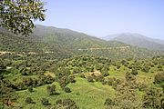
Wet season on the northern coast

Sparse vegetation in the Ninva

Dry season in the Mesewi Mountains

Wet season shrublands on the east coast


.jpg)

Government and politics
The Kembesan government is a federal constitutional monarchy.