User:Mansur al Hallaj/Sandbox2: Difference between revisions
Jump to navigation
Jump to search
No edit summary |
No edit summary |
||
| Line 60: | Line 60: | ||
| notes = | | notes = | ||
| campaignbox = | | campaignbox = | ||
}} | |||
{{Infobox country | |||
|conventional_long_name = Republic of Minkathala | |||
|native_name = ''మినాథాల గణతంత్ర రాజ్యము''<br>''République de Mincathale'' | |||
|common_name = Minkathala | |||
|image_flag = Flag of the Cooch Bihar State.svg | |||
|alt_flag = <!--alt text for flag (text shown when pointer hovers over flag)--> | |||
|image_flag2 = <!--e.g. Second-flag of country.svg--> | |||
|alt_flag2 = <!--alt text for second flag--> | |||
|image_coat = <!--e.g. Coat of arms of country.svg--> | |||
|alt_coat = <!--alt text for coat of arms--> | |||
|national_motto = <!--in inverted commas and wikilinked if link exists--> | |||
|national_anthem = ''మా కన్న తల్లికి మంగళారతులు''<br><small>"Veneration to the Great Mother that birthed us"</small> | |||
|image_map = Location map minkathala.png | |||
|alt_map = <!--alt text for map--> | |||
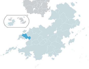
|map_caption = Minkathala in [[Coius]]. | |||
|image_map2 = <!--Another map, if required--> | |||
|alt_map2 = <!--alt text for second map--> | |||
|map_caption2 = <!--Caption to place below second map--> | |||
|status = Recognised as independent by [[ROSPO]] nations, as part of [[Arthakhand]] by [[COMSED]] nations. | |||
|capital = [[Kodangal]] | |||
|largest_city = capital | |||
|official_languages = {{wp|Telugu language|Minkathalan}} | |||
|national_languages = <!--Country/territory-wide languages recognised but not necessarily in country/territory-wide law, etc--> | |||
|regional_languages = <!--Languages recognised or associated with particular regions within the country/territory--> | |||
|ethnic_groups = {{wp|Telugu language|Minkathalan}}: 87%<br>[[Vanavasi]]: 4%<br>Others: 9% | |||
|ethnic_groups_year = 2020 | |||
|demonym = Minkathali | |||
|government_type = ''{{wp|De jure}}'': {{wp|Unitary state|Unitary}} {{wp|presidential republic}}, ''{{wp|De facto}}'': {{wp|Associated state}} of [[Arthakhand]] | |||
|leader_title1 = [[President of Minkathala|President]] | |||
|leader_name1 = [[Nirad Giri]] | |||
|leader_title2 = | |||
|legislature = [[Parliament of Minkathala|Parliament]] | |||
|upper_house = <!--Name of governing body's upper house, if given (e.g. "Senate")--> | |||
|lower_house = <!--Name of governing body's lower house, if given (e.g. "Chamber of Deputies")--> | |||
|sovereignty_type = {{wp|Associated state}} of [[Arthakhand]] | |||
|established_event1 = Independence from [[Gaullica]] | |||
|established_date1 = 1935 | |||
|established_event2 = [[Minkathala crisis|Arthakhandi invasion]] | |||
|established_date2 = <1989 | |||
|area = <!--Major area size (in [[Template:convert]] either km2 or sqmi first)--> | |||
|population_estimate = | |||
|population_estimate_year = | |||
|population_census = 8,091,367 | |||
|population_census_year = 2020 | |||
|population_density_km2 = | |||
|population_density_sq_mi = | |||
|GDP_nominal = $80.75 billion | |||
|GDP_nominal_year = 2020 | |||
|GDP_nominal_per_capita = $9,981 | |||
|HDI = 0.835 | |||
|HDI_year = 2020 | |||
|currency = <!--Name/s of currency/ies used in country/territory--> | |||
|time_zone = <!--e.g. GMT, PST, AST, etc, etc (wikilinked if possible)--> | |||
|utc_offset = <!--in the form "+N", where N is number of hours offset--> | |||
|date_format = <!--numeric dates (dd-mm-yyyy, yyyy.mm.dd, etc) plus era (CE, AD, AH, etc)--> | |||
|drives_on = <!--"right" or "left" (side of road)--> | |||
|cctld = <!--Internet country code top-level domain identifier (e.g. [[.br]], [[.de]], etc) | |||
|calling_code = <!--e.g. [[+1]], [[+531]], [[+44]], etc--> | |||
}} | }} | ||
Revision as of 05:19, 23 February 2021
| First Satrian War | ||||||||
|---|---|---|---|---|---|---|---|---|
| Part of Satrian Wars and conflicts | ||||||||
Clockwise from top:
| ||||||||
| ||||||||
| Belligerents | ||||||||
|
|
| Commies | ||||||
Republic of Minkathala మినాథాల గణతంత్ర రాజ్యము République de Mincathale | |
|---|---|
|
Flag | |
| Anthem: మా కన్న తల్లికి మంగళారతులు "Veneration to the Great Mother that birthed us" | |
 Minkathala in Coius. | |
| Status | Recognised as independent by ROSPO nations, as part of Arthakhand by COMSED nations. |
| Capital and largest city | Kodangal |
| Official languages | Minkathalan |
| Ethnic groups (2020) | Minkathalan: 87% Vanavasi: 4% Others: 9% |
| Demonym(s) | Minkathali |
| Government | De jure: Unitary presidential republic, De facto: Associated state of Arthakhand |
| Nirad Giri | |
| Legislature | Parliament |
| Associated state of Arthakhand | |
• Independence from Gaullica | 1935 |
| <1989 | |
| Population | |
• 2020 census | 8,091,367 |
| GDP (nominal) | 2020 estimate |
• Total | $80.75 billion |
• Per capita | $9,981 |
| HDI (2020) | 0.835 very high |


