Manaban: Difference between revisions
Manabanman (talk | contribs) |
Manabanman (talk | contribs) |
||
| Line 1: | Line 1: | ||
==Manaban== | ==Manaban== | ||
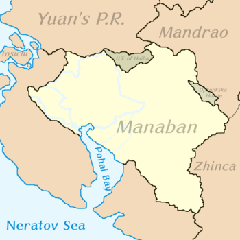
Officially the '''National Republic of Manaban''' , is a country in Southwestern [[Ausiana]], bordering north to [[Yuan]], [[The unincorporated territories of Haiha]] and [[Mandrao]]. To the East with Mandrao, [[The Opkepkska Horde]] [[Zhinca]], and to the south with the Neratov Sea and Pohai Bay. Encompassing almost a million square kilometers (exactly 900,000 sq km) it is considered a fair-sized country inside of its native continent, ruled by the [[Asiana Identity Coalition (澳西阿那身份聯盟)]] leadered by Prime Minister Zi Sirin Gioro. | Officially the '''National Republic of Manaban''' , is a country in Southwestern [[Ausiana]], bordering north to [[Yuan]], [[The unincorporated territories of Haiha]] and [[Mandrao]]. To the East with Mandrao, [[The Opkepkska Horde]] [[Zhinca]], and to the south with the Neratov Sea and [[Pohai Bay]]. Encompassing almost a million square kilometers (exactly 900,000 sq km) it is considered a fair-sized country inside of its native continent, ruled by the [[Asiana Identity Coalition (澳西阿那身份聯盟)]] leadered by Prime Minister Zi Sirin Gioro. | ||
<div style="float:right; line-height:2em;"> </div> | <div style="float:right; line-height:2em;"> </div> | ||
Revision as of 04:59, 28 October 2021
Manaban
Officially the National Republic of Manaban , is a country in Southwestern Ausiana, bordering north to Yuan, The unincorporated territories of Haiha and Mandrao. To the East with Mandrao, The Opkepkska Horde Zhinca, and to the south with the Neratov Sea and Pohai Bay. Encompassing almost a million square kilometers (exactly 900,000 sq km) it is considered a fair-sized country inside of its native continent, ruled by the Asiana Identity Coalition (澳西阿那身份聯盟) leadered by Prime Minister Zi Sirin Gioro.
Nationalist Republic of Manaban ᠮ᠊ᠠᠨ᠊ᠠᠪ᠊ᠠᠨᠨ᠋ ᡬ᠊᠊ᡠᠪ᠊ᠴ᠊ᡳ᠋ ᡳ᠊᠊ᡵ᠊ᡬ᠊᠊ᡝ᠊ᠨ᠋ ᡬ᠊ᡠ᠊᠊ᡵ᠊᠊ᡠ᠊ᠨ᠋ / Gubcin Irgen Manaban Gurun
滿阿半國民共和國/ Mǎnābàn guómín gònghéguó Үндэсний Бүгд Найрамдах Улс / Ündesniibügd Nairamdakhuls | |
|---|---|
|
Flag | |
| Motto: "Mini Mafa Gurun" | |
| Anthem: Yellow and purple fields | |
 | |
| Capital | Changhua |
| Largest city | Zihai'an |
| Official languages | Mannese, Southwestern Yauneze, Mingonian, Belogorskovi |
| Ethnic groups | Mannese, Yuaneze,Mingonian, Beleroskovi |
| Government | Assymetrical federalist parliamentary government |
• Prime Minister | Zi Sirin Gioro |
| Currency | (Mannese Yen) (滿元 (MBY)) |
| Calling code | +686 |
| Internet TLD | .mb |
Prehistory
Geography
Mannese lands used to be different to today's landscapes are. Approximately 45 million years ago, Manaban was mostly formed by a chain of islands which paleontologists have named the Sohontu Archipelago. The place that resembles these islands the most in current times is the westernmost wetlands of the Hugong river delta.
Fauna
Some of the most recently discovered animals in the Sontohu Archipelago are the Sabuharaptor, a mid-sized opportunist scavenger from the late periods. Its name literally means Saw thief.
Mudurisaurus, which is a large carnivorous draconic quadruped reptilian that dwelled in the warm tropical forest glades. Its fossils might be the reason why Mannese people are obsessed with dragons. So far, only 4 specimens have been registered.
And Akjanodon; literally thundertusk is the male characteristic for which they've been known. It's speculated these gigantic tusks were used to fend the carnivorous competition. One of the most competent animals of its era which was a marsupial rather than a reptile.
All of these animals are from different periods of time and islands.
