Dareza: Difference between revisions
(Created page with "{{Infobox islands | name = Dareza | image = Dareza (Sand Cay).jpg | image_caption = Aerial photograph of Dareza in 2018 | map = | map_caption = | l...") |
mNo edit summary |
||
| Line 20: | Line 20: | ||
| additional info = | | additional info = | ||
}} | }} | ||
'''Dareza''' is a {{wp|cay|coral cay}} in the eastern [[Sea of Velar]] and owned by [[Trellin]]. It is the largest cay in the [[Dareza Bank]], a {{convert| | '''Dareza''' is a {{wp|cay|coral cay}} in the eastern [[Sea of Velar]] and owned by [[Trellin]]. It is the largest cay in the [[Dareza Bank]], a {{convert|1700|sqkm|sqmi|adj=on}} atoll that lies midway between mainland [[Namija]] and the island of [[Kerypa]]. Dareza lies on the south-eastern edge of the atoll, {{convert|13|km|mi}} from the nearest permanent landmass, [[Sani]], which is an uninhabited cay, {{convert|87|km|mi}} southwest of the Namijan mainland and {{convert|58|km|mi}} northeast of Kerypa. Dareza is an oblong shape, oriented north-northeast to south-southwest. The highest point on the cay is {{convert|3.1|m|ft}} above sea level. | ||
The island is administered as part of the province of Namija by the Kerypan Assembly. Access to Dareza is facilitated by boat and by helicopter. Since the 1990s, the Kerypan Assembly has engaged in reclamation works on the island, using sand dredged from channel-clearing operations at [[Mintra]]. As of 2014, this had doubled the island's area to {{convert|10|ha|acres}}, with further reclamation underway at the northern end. Historical evidence indicates the cay was once virtually barren, but it is a valuable stopping point for seabirds, and rich guano deposits have allowed trees to be planted on the island. | The island is administered as part of the province of Namija by the Kerypan Assembly. Access to Dareza is facilitated by boat and by helicopter. Since the 1990s, the Kerypan Assembly has engaged in reclamation works on the island, using sand dredged from channel-clearing operations at [[Mintra]]. As of 2014, this had doubled the island's area to {{convert|10|ha|acres}}, with further reclamation underway at the northern end. Historical evidence indicates the cay was once virtually barren, but it is a valuable stopping point for seabirds, and rich guano deposits have allowed trees to be planted on the island. | ||
Latest revision as of 02:03, 22 April 2022
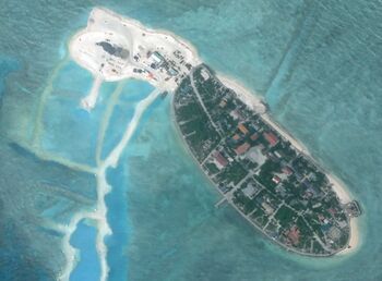
 Aerial photograph of Dareza in 2018 | |
| Geography | |
|---|---|
| Area | 0.10 km2 (0.039 sq mi) |
| Length | 0.51 km (0.317 mi) |
| Width | 0.28 km (0.174 mi) |
| Highest elevation | 3.1 m (10.2 ft) |
| Administration | |
| Province | Namija |
Dareza is a coral cay in the eastern Sea of Velar and owned by Trellin. It is the largest cay in the Dareza Bank, a 1,700-square-kilometre (660 sq mi) atoll that lies midway between mainland Namija and the island of Kerypa. Dareza lies on the south-eastern edge of the atoll, 13 kilometres (8.1 mi) from the nearest permanent landmass, Sani, which is an uninhabited cay, 87 kilometres (54 mi) southwest of the Namijan mainland and 58 kilometres (36 mi) northeast of Kerypa. Dareza is an oblong shape, oriented north-northeast to south-southwest. The highest point on the cay is 3.1 metres (10 ft) above sea level.
The island is administered as part of the province of Namija by the Kerypan Assembly. Access to Dareza is facilitated by boat and by helicopter. Since the 1990s, the Kerypan Assembly has engaged in reclamation works on the island, using sand dredged from channel-clearing operations at Mintra. As of 2014, this had doubled the island's area to 10 hectares (25 acres), with further reclamation underway at the northern end. Historical evidence indicates the cay was once virtually barren, but it is a valuable stopping point for seabirds, and rich guano deposits have allowed trees to be planted on the island.
Dareza is considered of strategic importance for managing navigation through the treacherous Dareza Bank, which lies on the busiest shipping route in the eastern Sea of Velar. A signal has been maintained on the island since the 1700s, which led to permanent settlement by the early nineteenth century. A lighthouse was erected at the island's southern end in 1963.