Sarnoem: Difference between revisions
No edit summary |
No edit summary |
||
| Line 154: | Line 154: | ||
== History == | == History == | ||
[[File:sarnoem_hero.jpg|200px|thumbnail|left|Illustration of the legendary hero, Oelaesk, wearing a souloet around the transition era.]] | |||
The general history of the country consists of 3 eras: | |||
* Post-classical empire, c720 | |||
* Transition territories, 1600 | |||
* Modern sovereignty, 1952 | |||
There had always been steady demographics changes within the landscapes as the dominant culture always welcomes anyone but also forgoes those who no longer remain. The modern borders of the nation were mainly solidified upon the independence of this nation in 1952 after the [[Third Voshan War]]. True to the non-democratic nature of its government system, mostly the northern and eastern sides of this region were slightly influenced by Atmora in the [[Winter War (Halkeginia)|Winter War]]. In the modern age, the voluntary merges respecting the local people in said particular regions and together with geographic factors, result in this place suitably known as Sarnoem Borderlands. | |||
Few inventions and discoveries were credited to this region, though the origins of the pioneers themselves are related to mixed provinces in the past. The distance between the Sun and Heliste was discovered by Shaegleg in 1531 when he was a visiting scholar in the eastern region. {{wpl|Dynamite}} was invented by Everg in 1877 while working in the Nuzdauim mine in the northern region. | |||
The flag was designed with certain symbolism when the nation was built. Some of these concepts have no direct analogue upon translation. Red represents the directness of action, whereas white represents the clarity of thought. The left triangle represents the production of resources, whereas the right triangle represents the utilisation of resources. | |||
== Geography == | == Geography == | ||
| Line 162: | Line 173: | ||
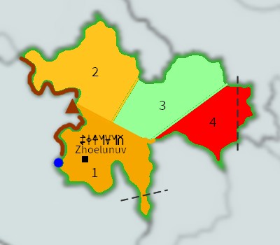
[[File:sarnoem_map.jpg|400px|thumb|center|States in Sarnoem (1: Raikelsyrtaens. 2: Causelsyrtaens. 3: Fiabelsyrtaens. 4: Hiodelsyrtaens). Brown triangle represents Mount Yshtviag. Brown line represents its mountain range. Blue circle represents Lake Guljaip. Black square represents the capital city. Dotted lines represent disputed borders.]] | [[File:sarnoem_map.jpg|400px|thumb|center|States in Sarnoem (1: Raikelsyrtaens. 2: Causelsyrtaens. 3: Fiabelsyrtaens. 4: Hiodelsyrtaens). Brown triangle represents Mount Yshtviag. Brown line represents its mountain range. Blue circle represents Lake Guljaip. Black square represents the capital city. Dotted lines represent disputed borders.]] | ||
{ | <div style="width:75%; margin:0 auto;"> | ||
| | {| class="wikitable" | ||
| | !colspan="6" style="background-color:#ccccff;"|Largest cities or towns in Sarnoem | ||
| | |- | ||
| | | style="background-color:#ccccff; width:200px;" | | ||
| | | style="background-color:#ccccff; width:50px; text-align:center;" | <b>Rank </b> | ||
| | | style="background-color:#ccccff; width:150px; text-align:center;" | <b>Town</b> | ||
-- | | style="background-color:#ccccff; width:150px; text-align:center;" | <b>State</b> | ||
| | | style="background-color:#ccccff; width:100px; text-align:center;" | <b>Population</b> | ||
| | | style="background-color:#ccccff; width:200px" | | ||
| | |- | ||
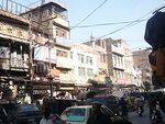
| | |rowspan="10"|[[File:sarnoem_town1.jpg|150px|center]] | ||
| | | 1 || Zhoelunuv || Raikelsyrtaens | ||
| | | style="text-align:right;" | 8394000 | ||
| | |rowspan="10"|[[File:sarnoem_town2.jpg|150px|center]] | ||
| | |- | ||
| | | 2 || Juthcaehyr || Causelsyrtaens | ||
| | | style="text-align:right;" | 3602000 | ||
| | |- | ||
| | | 3 || Diltsuayob || Fiabelsyrtaens | ||
| | | style="text-align:right;" | 2298000 | ||
| | |- | ||
| 4 || Kalenju || Hiodelsyrtaens | |||
< | | style="text-align:right;" | 1120000 | ||
|- | |||
| 5 || Shaegur || Raikelsyrtaens | |||
| style="text-align:right;" | 927900 | |||
|- | |||
| 6 || Naeionav || Causelsyrtaens | |||
| style="text-align:right;" | 909200 | |||
|- | |||
| 7 || Setmoezol || Fiabelsyrtaens | |||
| style="text-align:right;" | 776300 | |||
|- | |||
| 8 || Baegalz || Hiodelsyrtaens | |||
| style="text-align:right;" | 605700 | |||
|- | |||
| 9 || Naxolsvaef || Raikelsyrtaens | |||
| style="text-align:right;" | 579300 | |||
|- | |||
| 10 || Oelnauk || Causelsyrtaens | |||
| style="text-align:right;" | 524200 | |||
|} | |||
</div> | |||
{{Weather box | {{Weather box | ||
Revision as of 00:32, 4 October 2023
Sarnoem Borderlands | |
|---|---|
|
Flag | |
| Motto: xaeish un yngz (Romanisation) "Courage and knowledge" (Translation) | |
| Anthem: Jiska ki ynt | |
 Sarnoem (green) in Arborea | |
| Capital and largest city | Zhoelunuv |
| Official languages | Griushkoent |
Additional languages | Aellyrian (54%), Arboreaic Dutch (25%), other dialects |
| Ethnic groups | 89% Sarnoeme (including mixed), 11% minorities |
| Religion |
|
| Demonym(s) | Sarnoeme |
| Government | Confederated anarchism |
• Leader | Orzhoer |
| Establishment | |
• Pre Empire | c720 |
• Transition territories | 1600 |
• Modern sovereignty | 1952 |
| Area | |
• Total | 582,464 km2 (224,891 sq mi) |
| Population | |
• 2015 estimate | 51 million |
• Density | 89/km2 (230.5/sq mi) |
| GDP (nominal) | 2015 estimate |
• Total | $8.16 x 10¹¹ |
• Per capita | $16000 (2015) |
| Currency | Luyiath (LYT) |
| Time zone | UTC+8 |
| Date format | DD/SS/YY SY |
| Driving side | left |
| Calling code | +15 |
| Internet TLD | .sn |
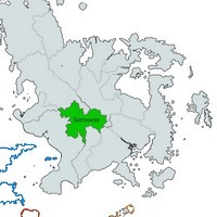
Sarnoem (IPA: /'sarnɯm/) is a landlocked country in the middle of Arborea. Aellyria is located at its west across the Sea of Lights, whereas Castarcia is located east ahead of the international date line across the Sea of Folly. It has a mountainous terrain on its western border and most of the country has a semi-arid climate. Despite being the land of many border changes over many eras, the steadfast usage and preservation of the predominant language of the region made it gain a rich literary tradition, and continues to expand with modern techniques.
The word "Sarnoem" does not mean anything in the native language. Upon the formation of the country in the mid-1900s, the name was chosen to refer to a place in one of its ancient epics, whereby said inhabitants were running from the ruins of a once indestructible kingdom towards the mountains, then waiting and preparing to restore it to its former glory. This passage represents the contemporary ideals of the current nation.
History
The general history of the country consists of 3 eras:
- Post-classical empire, c720
- Transition territories, 1600
- Modern sovereignty, 1952
There had always been steady demographics changes within the landscapes as the dominant culture always welcomes anyone but also forgoes those who no longer remain. The modern borders of the nation were mainly solidified upon the independence of this nation in 1952 after the Third Voshan War. True to the non-democratic nature of its government system, mostly the northern and eastern sides of this region were slightly influenced by Atmora in the Winter War. In the modern age, the voluntary merges respecting the local people in said particular regions and together with geographic factors, result in this place suitably known as Sarnoem Borderlands.
Few inventions and discoveries were credited to this region, though the origins of the pioneers themselves are related to mixed provinces in the past. The distance between the Sun and Heliste was discovered by Shaegleg in 1531 when he was a visiting scholar in the eastern region. Dynamite was invented by Everg in 1877 while working in the Nuzdauim mine in the northern region.
The flag was designed with certain symbolism when the nation was built. Some of these concepts have no direct analogue upon translation. Red represents the directness of action, whereas white represents the clarity of thought. The left triangle represents the production of resources, whereas the right triangle represents the utilisation of resources.
Geography
According to atlases, Sarnoem is shaped like a moth or clover leaf. Sarnoem consists of 4 states: Raikelsyrtaens, Causelsyrtaens, Fiabelsyrtaens and Hiodelsyrtaens. The capital city, Zhoelunuv, itself is located in Raikelsyrtaens. There are a few areas of dispute regarding international borders, particularly at the eastern boundary.
Raikelsyrtaens is the most developed state in Sarnoem, situated at the southwestern corner with its numerous lakes on the hinterland and BSh semi-arid climate. Causelsyrtaens follows northwards of Raikelsyrtaens along the mountain range on the west. Fiabelsyrtaens includes the eastern region whereby its highlands have a more temperate climate. At the southeastern edge, the least populated state, Hiodelsyrtaens, is more of a desert landscape and also features the Golnagoeym Pass.
| Largest cities or towns in Sarnoem | |||||
|---|---|---|---|---|---|
| Rank | Town | State | Population | ||
| 1 | Zhoelunuv | Raikelsyrtaens | 8394000 | ||
| 2 | Juthcaehyr | Causelsyrtaens | 3602000 | ||
| 3 | Diltsuayob | Fiabelsyrtaens | 2298000 | ||
| 4 | Kalenju | Hiodelsyrtaens | 1120000 | ||
| 5 | Shaegur | Raikelsyrtaens | 927900 | ||
| 6 | Naeionav | Causelsyrtaens | 909200 | ||
| 7 | Setmoezol | Fiabelsyrtaens | 776300 | ||
| 8 | Baegalz | Hiodelsyrtaens | 605700 | ||
| 9 | Naxolsvaef | Raikelsyrtaens | 579300 | ||
| 10 | Oelnauk | Causelsyrtaens | 524200 | ||
| Month | Jan | Feb | Mar | Apr | May | Jun | Jul | Aug | Sep | Oct | Nov | Dec | Year |
|---|---|---|---|---|---|---|---|---|---|---|---|---|---|
| Daily mean °C (°F) | 11.0 (51.8) |
14.2 (57.6) |
18.4 (65.1) |
22.2 (72.0) |
25.4 (77.7) |
26.9 (80.4) |
27.3 (81.1) |
27.3 (81.1) |
25.5 (77.9) |
22.4 (72.3) |
17.3 (63.1) |
12.7 (54.9) |
20.9 (69.6) |
| Average precipitation mm (inches) | 10 (0.4) |
16 (0.6) |
43 (1.7) |
84 (3.3) |
142 (5.6) |
175 (6.9) |
190 (7.5) |
148 (5.8) |
170 (6.7) |
88 (3.5) |
20 (0.8) |
13 (0.5) |
1,098 (43.2) |
| Mean monthly sunshine hours | 216 | 226 | 238 | 240 | 254 | 235 | 232 | 225 | 212 | 270 | 253 | 228 | 2,830 |
| Source: Sarnoem Geography Department. Numbers were converted to international units. | |||||||||||||
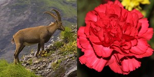
Yshtviag mountain is the tallest mountain in Sarnoem with a height of 4196 m, and is situated on the Yshtviag Skoens, the western mountain range. Lake Guljaip is located at the southern base of said mountain range. The national animal of Sarnoem is the ibex and is part of the wildlife on the mountains. The national flower is the carnation and they are grown in the highland regions.
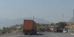
With its high elevation and difficult traversal conditions, the Skoens Expressway is an important route along the western mountain range. Along any highways or long roads, there are many teahouses for rest pit stops. Such motorway services and public bath houses are also a common sight in neighbourhoods. Hospitality to guests, in addition to expecting nothing in return, is an honoured principle in the local culture. On some high-density residential buildings, a new mode of transportation similar to ziplines is installed to send bundles, and also to ferry carriers across a busy street against safety regulations.
Politics
Unusually classified, Sarnoem features a functioning anarchistic society, but it is sometimes able to appear as an oligarchy when externally interacting with other nations. It also seems to have a non-hierarchial central government, also known as the default government, that stands as a main reference or facilitator, but can be dismissed by the public and is commonly superseded by other equivalent organisations instead. Moreover, a governmental structure can spontaneously form, dissolve soon afterwards, or remain in-flux according to the needs of the circumstance. Similarly, the states in this confederation often have high autonomy regarding how they run themselves.
The leader of the country is called saeth, also translated as king despite having no characteristics as compared to an actual monarch. In an anarchistic country, the leader decides on the main guidelines and provisions for its country. The king also makes decisions on behalf of the entire country regarding international affairs. However, each default department, organisation, community or individual is lawfully allowed to not adhere as they see fit. Incidentally, massive non-compliance is actually rare due to voluntary selection principles.
Orzhoer (IPA: /'ɔrʒɯr/) is the current saeth of Sarnoem. The longer title "Orzhoer saeth" or "Orzhoer king" is never used except for disambiguation. He became saeth in 1295 SY (2015). A few years before that, he graduated with a Masters of Applied Mathematics from Zhoelunuv University. In fact, the decision to tentatively put forth a leader is one of the few times when a democracy-like system is applied in this country's political matters. Candidates, including the current reigning saeth, is contested in each state. Then, the saeth can either accept the results, or decline it and the next best candidate will be the new self-proclaimed saeth. Note that this is also based on a voluntary system, and the public could easily overturn the outcome.
Sarnoem's military is fronted and backed by the Stej Ijzoulke (army), Ynt Ijzoulke (air force) and the Caedz Ijzoulke (navy), though the last one has a far lower amount of units because their only main importance is to patrol the lake border. There are approximately 180000 people in the military, and 76000 more in reserve. Its military expenditure consists of 4.5% of its GDP spending, but as usual in any economics-based calculations for anarchistic models, this is difficult to gauge due to complications as to what counts as transaction involving money. Moreover, it shares the budget with security and emergency services.
Sarnoem usually is not a signatory member of any convention. It is known to violate a few of them. Sometimes, it even follows parts of a treaty when not part of one. Sarnoem shows an air of neutrality as a net result, but upon closer inspection, it is only because there are many independent acting groups, each with their own political affiliations, often with no clear indicator of any major stance, except the obvious one provided by the saeth. Regionally or internationally, it diplomatically maintains tight foreign relations only with those who could truly negotiate through its dissimilar political and economical tendencies.
Economy
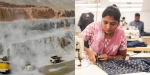
The country has a gift economy system. One only uses money or currency when trading externally or in up-tier transactions. The main exports of the country are coats and sugarcane, whereas the main imports are oil and machinery. The mining, manufacturing and textile industries comprise a large sector of the economy. The country is self-sufficient on its energy supply from coal power stations and off-grid sustainability programmes, but blackouts do occur at times when there is a sharp increase in demand for electricity during peak hours. It is estimated that there is a prospective amount of untapped petroleum in the southern region.
Cotton, sugarcane, wheat and tea can be found growing in most parts of the country, whereas berries are farmed in the northeastern highlands. Mineral deposits include chromite, dolomite, coal, peridot, bastnaestite and other ores that are mined and processed in the country. Tourism is less attractive here due to its remoteness and lack of services in rural areas, but it does attract backpackers and hence increase the interest in upkeeping homestays. The largest shopping centre in Sarnoem was built in the southern desert region, and even showcases an indoor snowboarding winter wonderland. Otaegaen, the multinational customisable homeware company, has its headquarters here in Causelsyrtaens. Roeshyng, the fast fashion clothing company, also has several production outlets throughout the whole country.


