Cadenzan Kamalbia: Difference between revisions
mNo edit summary |
|||
| (One intermediate revision by the same user not shown) | |||
| Line 30: | Line 30: | ||
|national_anthem = <!-- Accepts wikilinks --> | |national_anthem = <!-- Accepts wikilinks --> | ||
|political_subdiv = <!-- Accepts wikilinks --> | |political_subdiv = <!-- Accepts wikilinks --> | ||
|today = {{flag|Kamalbia}} | |today = {{flag|Oduya}} {{flag|South Kamalbia}} | ||
<!-- Rise and fall, events, years and dates --> | <!-- Rise and fall, events, years and dates --> | ||
<!-- Only fill in the start/end event entry if a specific article exists. Don't just say "abolition" or "declaration". --> | <!-- Only fill in the start/end event entry if a specific article exists. Don't just say "abolition" or "declaration". --> | ||
| Line 88: | Line 88: | ||
In 1622, diamonds were discovered in Kamalbia, leading to an influx of mainly Cadenzan settlers. Tyúregar quickly grew to become a major port as the terminus for Cadenzan treasure ship routes. | In 1622, diamonds were discovered in Kamalbia, leading to an influx of mainly Cadenzan settlers. Tyúregar quickly grew to become a major port as the terminus for Cadenzan treasure ship routes. | ||
[[Jakúba Kimepra]] undertook a series of administrative reforms upon his accession to the earldom. He authorised a map-making commission in 1790 which found the highest point in Kamalbia and named it [[Mount Kimepra]] in his honour. | [[Jakúba Kimepra]] undertook a series of administrative reforms upon his accession to the earldom. He authorised a map-making commission in 1790 which found the highest point in Kamalbia and named it [[Mount Kimepra]] in his honour. While Kamalbia was a Cadenzan possession, Mount Kimepra was the country's tallest mountain. | ||
[[Category:Earldoms of Cadenza|*Kamalbia]][[Category:Cadenza]][[Category:Trellin]][[Category:Kamalbia]][[Category:Astyria]] | [[Category:Earldoms of Cadenza|*Kamalbia]][[Category:Cadenza]][[Category:Trellin]][[Category:Kamalbia]][[Category:Astyria]] | ||
Latest revision as of 05:44, 25 March 2024
This article is incomplete because it is pending further input from participants, or it is a work-in-progress by one author. Please comment on this article's talk page to share your input, comments and questions. Note: To contribute to this article, you may need to seek help from the author(s) of this page. |
| Cadenzan Kamalbia Khamalb | |||||
| Earldom of Cadenza | |||||
| |||||
 Flag Flag
| |||||
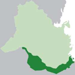
| Cadenzan Kamalbia (dark green) within modern Kamalbian borders (light green) | |||||
| Capital | Tyúregar | ||||
| Government | Self-governing colony | ||||
| Earl | |||||
| • | 1620-49 | Tariq Kimepra | |||
| • | 1787-1814 | Jakúba Kimepra | |||
| History | |||||
| • | Peace of Portus Regalis | 1618 | |||
| • | Cession of Somethingsomething | 1814 | |||
| Today part of | File:Flag of Oduya.png Oduya Template:Country data South Kamalbia | ||||
Cadenzan Kamalbia (Khadenz: Khamalb) was a self-governing dependency of the Maritime Republic of Cadenza between 1618 and 1814 and a Cadenzan earldom from 1620. It consisted of the former territory of Exponential Kamalbia, which was sold to Cadenza as part of the Peace of Portus Regalis that concluded the War of the Magpie and the Dragon. For almost two centuries it was the main source of diamonds and other mineral wealth for the Cadenzan empire. The earldom was occupied by Beriquois forces during the Bernadottic Wars and was ceded in 1814.
History
Prior to becoming a Cadenzan territory, southern Kamalbia had been a possession of the Exponential Empire. In 1615, during the War of the Magpie and the Dragon, its capital was attacked and seized by an army under Tariq Kimepra, who went on to occupy the rest of the province. Exponent attempted and failed to dislodge the occupying force, and the territory was consequently sold as part of the Treaty of Portus Regalis in 1618. The capital, Ialica, was rebuilt as the city of Tyúregar. In 1620, the Earls Council voted to co-opt Admiral Kimepra as earl of Kamalbia and established the colony as a self-governing dependency.
In 1622, diamonds were discovered in Kamalbia, leading to an influx of mainly Cadenzan settlers. Tyúregar quickly grew to become a major port as the terminus for Cadenzan treasure ship routes.
Jakúba Kimepra undertook a series of administrative reforms upon his accession to the earldom. He authorised a map-making commission in 1790 which found the highest point in Kamalbia and named it Mount Kimepra in his honour. While Kamalbia was a Cadenzan possession, Mount Kimepra was the country's tallest mountain.
