Kembesa: Difference between revisions
mNo edit summary |
mNo edit summary |
||
| (88 intermediate revisions by 2 users not shown) | |||
| Line 1: | Line 1: | ||
{{WIP}} | |||
{{Region_icon_Ajax}} | {{Region_icon_Ajax}} | ||
{{Infobox country | {{Infobox country | ||
|conventional_long_name = | |conventional_long_name = Empire of Kembesa | ||
|native_name = | |native_name = {{collapsible list | ||
|titlestyle = background:transparent;text-align:center;line-height:normal;font-size:84%; | |||
|title = Official names | |||
| {{Infobox|subbox=yes|bodystyle=font-size:77%;font-weight:normal; | |||
| rowclass1 = mergedrow | label1 = {{wp|Amharic language|Meharic}}: | |||
| data1 = ዬከምብሥያ ንጉሣ ነገስት መንግሥት<br>''Ye'kembesiya Negusa Negest Mengest'' | |||
| rowclass2 = mergedrow | label2 = {{wp|Tigrinya language|Degamic}}: | |||
| data2 = ሃፀያዊ ግዘአት ከምበሳ</br>''Haṣeyawi Gezeʼat Kembesa'' | |||
| rowclass3 = mergedrow | label3 = {{wp|Oromo language|Masaric}}: | |||
| data3 = ሞኦቱምሟ ሞኦቱምሞኦቷ Kአምበሷ<br>''Mootummaa Mootummootaa Kembesaa'' | |||
| rowclass4 = mergedrow | label4 = {{wp|Somali language|Janubic}}: | |||
| data4 = ቦቆርቶኦያዳ Wአይን ኤ Kአምበስካ<br>''Boqortooyada Weyn ee Kembeska'' | |||
}}}} | |||
|common_name = Kembesa | |||
|image_flag = Kembesa Flag.png | |image_flag = Kembesa Flag.png | ||
|alt_flag = <!--alt text for flag (text shown when pointer hovers over flag)--> | |alt_flag = <!--alt text for flag (text shown when pointer hovers over flag)--> | ||
| Line 9: | Line 23: | ||
|alt_flag2 = <!--alt text for second flag--> | |alt_flag2 = <!--alt text for second flag--> | ||
|flag2_border = <!--set to no to disable border around the flag--> | |flag2_border = <!--set to no to disable border around the flag--> | ||
|image_coat = Kembesa | |image_coat = Kembesa CoA.png | ||
|alt_coat = <!--alt text for coat of arms--> | |alt_coat = <!--alt text for coat of arms--> | ||
|symbol_type = | |symbol_type = Coat of arms | ||
|national_motto = | |national_motto = | ||
|englishmotto = | |englishmotto = | ||
|national_anthem = | |national_anthem = {{wp|March Forward, Dear Mother Ethiopia|March Forward, Kembesa!}} | ||
|royal_anthem = | |royal_anthem = {{wp|Ethiopia, Be Happy|Kembesans, Rejoice!}} | ||
|other_symbol_type = <!--Use if a further symbol exists, e.g. hymn--> | |other_symbol_type = <!--Use if a further symbol exists, e.g. hymn--> | ||
|other_symbol = | |other_symbol = | ||
| Line 25: | Line 39: | ||
|alt_map2 = <!--alt text for second map--> | |alt_map2 = <!--alt text for second map--> | ||
|map_caption2 = <!--Caption to place below second map--> | |map_caption2 = <!--Caption to place below second map--> | ||
|capital = Azwa | |capital = [[Azwa]] | ||
|coordinates = | |coordinates = | ||
|largest_city = | |largest_city = | ||
|largest_settlement_type = | |largest_settlement_type = | ||
|largest_settlement = | |largest_settlement = | ||
|official_languages = {{wpl|Amharic| | |official_languages = {{wpl|Amharic|Meharic}} | ||
|national_languages = < | |national_languages = {{wpl|Tigrinya|Degamic}}</br>{{wpl|Oromo language|Masaric}}</br>{{wpl|Somali language|Janubic}} | ||
|regional_languages = {{wpl|Arabic|Gharbaic}}</br>{{ | |regional_languages = {{wpl|Arabic|Gharbaic}}</br>{{wp|Ossetian language|Dardaloni}}</br>{{wpl|Bantu languages|M'bweni}} | ||
|ethnic_groups = <!--List/breakdown of ethnic groups within the country/territory--> | |ethnic_groups = <!--List/breakdown of ethnic groups within the country/territory--> | ||
|ethnic_groups_year = <!--Year of ethnic groups data (if provided)--> | |ethnic_groups_year = <!--Year of ethnic groups data (if provided)--> | ||
| Line 45: | Line 53: | ||
|religion_year = <!--Year of religion data (if provided)--> | |religion_year = <!--Year of religion data (if provided)--> | ||
|religion_ref = <!--(for any ref/s to associate with religion data)--> | |religion_ref = <!--(for any ref/s to associate with religion data)--> | ||
|demonym = | |demonym = Kembesan | ||
|government_type = {{wpl| | |government_type = {{wpl|Federalism|Federal}} {{wpl|constitutional monarchy}} | ||
|leader_title1 = | |leader_title1 = Emperor | ||
|leader_name1 = | |leader_name1 = Hailu II Yemata | ||
|leader_title2 = | |leader_title2 = Chancellor | ||
|leader_name2 = | |leader_name2 = Tesfaldet Woldemesfin<sup>†</sup> | ||
|leader_title3 = | |leader_title3 = | ||
|leader_name3 = | |leader_name3 = | ||
|legislature = | |legislature = Imperial Parliament | ||
|upper_house = | |upper_house = Noble Assembly | ||
|lower_house = | |lower_house = Popular Assembly | ||
|sovereignty_type = <!--Brief description of country/territory's status ("Independence [from...]", "Autonomous province [of...]", etc)--> | |sovereignty_type = <!--Brief description of country/territory's status ("Independence [from...]", "Autonomous province [of...]", etc)--> | ||
|sovereignty_note = | |sovereignty_note = | ||
|established_event1 = Kingdom of | |established_event1 = {{nowrap|Yematid Kingdom of Meharia}} | ||
|established_date1 = | |established_date1 = June 28, 1858 | ||
|established_event2 = | |established_event2 = Empire of Kembesa | ||
|established_date2 = | |established_date2 = September 19, 1930 | ||
|established_event3 = | |established_event3 = Constitutional monarchy | ||
|established_date3 = | |established_date3 = October 23, 1936 | ||
|established_event4 = | |established_event4 = | ||
|established_date4 = | |established_date4 = | ||
|area_rank = | |area_rank = | ||
|area = | |area = | ||
|area_km2 = | |area_km2 = 665216 | ||
|area_sq_mi = | |area_sq_mi = | ||
|area_footnote = | |area_footnote = | ||
|percent_water = | |percent_water = 0.92 | ||
|area_label = Total | |area_label = Total | ||
|area_label2 = | |area_label2 = | ||
| Line 78: | Line 86: | ||
|population_estimate_rank = | |population_estimate_rank = | ||
|population_estimate_year = | |population_estimate_year = | ||
|population_census = | |population_census = 35,084,331 | ||
|population_census_year = | |population_census_year = 2024 | ||
|population_density_km2 = | |population_density_km2 = 52.74 | ||
|population_density_sq_mi = | |population_density_sq_mi = | ||
|population_density_rank = | |population_density_rank = | ||
| Line 89: | Line 97: | ||
|GDP_PPP_per_capita = | |GDP_PPP_per_capita = | ||
|GDP_PPP_per_capita_rank = | |GDP_PPP_per_capita_rank = | ||
|GDP_nominal = $ | |GDP_nominal = $655 billion | ||
|GDP_nominal_rank = | |GDP_nominal_rank = 2024 | ||
|GDP_nominal_year = | |GDP_nominal_year = | ||
|GDP_nominal_per_capita = $18,672 | |GDP_nominal_per_capita = $18,672.02 | ||
|GDP_nominal_per_capita_rank = | |GDP_nominal_per_capita_rank = | ||
|Gini = | |Gini = 61.9 | ||
| | |Gini_change = increase | ||
|Gini_rank = | |Gini_rank = | ||
|Gini_year = | |Gini_year = 2024 | ||
|HDI_year = | |HDI_year = 2024 | ||
|HDI = | |HDI = 0.76 | ||
|HDI_change = | |HDI_change = steady | ||
|HDI_rank = | |HDI_rank = | ||
|HDI_ref = <!--(for any ref/s to associate with HDI number)--> | |HDI_ref = <!--(for any ref/s to associate with HDI number)--> | ||
|currency = {{wpl|Ethiopian birr|Werik (<del> | |currency = {{wpl|Ethiopian birr|Werik (<del>ዌ</del>)}} | ||
|currency_code = KBW | |currency_code = KBW | ||
|time_zone = <!--e.g. GMT, PST, AST, etc, etc (wikilinked if possible)--> | |time_zone = <!--e.g. GMT, PST, AST, etc, etc (wikilinked if possible)--> | ||
|utc_offset = <!--in the form "+N", where N is number of hours offset--> | |utc_offset = <!--in the form "+N", where N is number of hours offset--> | ||
|antipodes = <!--Place/s exactly on the opposite side of the world to country/territory--> | |antipodes = <!--Place/s exactly on the opposite side of the world to country/territory--> | ||
|date_format = <!--all-numeric date format and era, such as [[Common Era|CE]], [[Anno Domini|AD]], [[Hijri year|AH]], etc.; e.g. {{abbr|yyyy|year}}-{{abbr|mm|month}}-{{abbr|dd|day}} ([[Anno Domini|AD]]) --> | |date_format = <!--all-numeric date format and era, such as [[Common Era|CE]], [[Anno Domini|AD]], [[Hijri year|AH]], etc.; e.g. {{abbr|yyyy|year}}-{{abbr|mm|month}}-{{abbr|dd|day}} ([[Anno Domini|AD]]) --> | ||
|electricity = <!--e.g. "230 V–50 Hz"--> | |electricity = <!--e.g. "230 V–50 Hz"--> | ||
|drives_on = <!--"right" or "left" (side of road)--> | |drives_on = <!--"right" or "left" (side of road)--> | ||
|calling_code = +530 | |||
|calling_code = | |||
}} | }} | ||
The '''Empire of Kembesa''' is a nation in East Scipia. It is bordered to the northeast by [[Fahran]], the northwest by [[Charnea]], and the southwest by [[M'biruna]]. The imperial capital of Kembesa is the city of [[Azwa]], which is also the capital of the Kingdom of Meharia. | |||
Kembesa is ostensibly a confederation of four nations ruled by the Yematid dynasty including the core Kingdom of Meharia, the Principality of Degama, the Duchy of Masara, and the Kingdom of Janubia. The term “Kembesa” has historically been associated with the region south of Fahran, beyond the borders of the Zahra Desert and before M'biruna. The name "Kembesa" roughly translates to “Land of the Lions” in the ancient She’dje language of the region. | |||
The modern state of Kembesa was founded in 1930 after over 70 years of military expansion. The Kembesan constitution was introduced in 1936 following significant clamour for reform and liberalization. Each constituent nation has maintained a degree of local autonomy under the constitution, though the imperial government maintains supreme authority over the subnational and district governments. | |||
Economically, most of Kembesa has successfully industrialized despite continued wealth inequality. One of the greatest issues is power as the early-20th century power grid is both aging and inadequate to sustain the demand of the population which has increased rapidly over the past hundred years. Geographically, Kembesa has a varied topography with hills and desert in the north, river basins in the east, and rainforests in the far south. | |||
== | ==History== | ||
The earliest material evidence of human habitation in Kembesa dates to approximately 2700 BCE. The first central state of the region was the Kingdom of Ke'sem, founded in the mid-10th century BCE. Through much of antiquity, however, the region was unstable, with a number of competing tribal confederations vying for control over the region. By the mid first millennium BCE, the rival kingdoms of Melewa and Yebwi exercised significant control over the region. | |||
[[File:Ras Mekonnen Amba Alage 2.jpg|left|thumb|284x284px|1895 patriotic newspaper print of King Hailu IV Yemata conquering Degama in 1864.]] | |||
Kembesa is perhaps best known as the birthplace of Mesfin, the warrior-king and founder of the Azdarin faith. Born sometime in the mid-10th century CE, Mesfin was the adopted son of a regional Mehari chief who was guided by the seeress Amsalech an appointed as the chosen of Gedayo. Mesfin became the leader of an army of freed slaves and conquered the kingdoms of Kembesa to found a new theocratic state. Mesfin died in 985 CE and his empire dissolved. However, Gharib followers of Mesfin to the north of Kembesa carried on in his name and founded the Almurid Caliphate in 993 CE. The Caliphate expanded across Scipia and continued to occupy Kembesa until the Ihemodian conquests of the 14th century. Ihemod ultimately died on campaign in Kembesa, but the Caliphate was never reunifed and the region of Kembesa was divided between a number of kingdoms again, though the Azdarin faith remained strong in the region. | |||
[[File: | |||
The Yematid dynasty came to power in the Kingdom of Meharia in 1858, beginning a war of expansion that resulted in the conquests of Degama in 1864 and Masara in 1879. The Kingdom of Janubia was conquered by Meharia during the chaos of the Hanaki War in 1930, following which King Mengesha III Yemata proclaimed the Empire of Kembesa. Clamour for reform lead swiftly to liberalization and national reorganization with the introduction of a constitution in 1936. | |||
==Geography and climate== | ==Geography and climate== | ||
[[File:Kembesa Köppen Map.png| | Kembesa has four approximate geographic regions. These are the eastern reaches of the Zahra desert in the country's northwest; the Mesewi Mountains, a series of low mountains, including the important holy site of [[Nutum Inyaru]]; and the eastern coast region which includes the Kumanaan Archipelago, the largest island of which is Bariga Island. | ||
Kembesa | [[File:Kembesa Köppen Map.png|240px|thumb|right| | ||
{{legend|#FF0000|{{wp|Desert_climate#Hot_desert_climates|BWh - hot desert}}}} | |||
{{legend|#FF9596|{{wp|Desert_climate#Cold_desert_climates|BWk - cold desert}}}} | |||
{{legend|#F5A500|{{wp|Semi-arid_climate#Hot_semi-arid_climates|BSh - hot semi-arid}}}} | |||
{{legend|#FED95E|{{wp|Semi-arid_climate#Cold_semi-arid_climates|BSk - cold semi-arid}}}} | |||
{{legend|#0000FF|{{wp|Tropical rainforest climate|Af - tropical rainforest}}}} | |||
{{legend|#0078FF|{{wp|Tropical monsoon climate|Am - tropical monsoon}}}} | |||
{{legend|#46AAFA|{{wp|Tropical savanna climate|Aw - tropical savanna}}}} | |||
{{legend|#63C764|{{wp|Oceanic_climate#Subtropical_highland_variety_(Cfb,_Cwb)|Cwb - subtropical highland}}}} | |||
]] | |||
In terms of climate, Kembesa experiences a range of climates between the hot arid desert in the northwest and the more temperate Periclean climate type in the east. The Zahra desert has very elevated temperatures and little average precipitation over the course of a year. While less extreme than the bulk of the desert to the west, it is not uncommon for the desert to see under 10 mm of precipitation over the course of a year. The Mesewi Mountains and the eastern coast are broadly characterized as semi-arid to savannah, experiencing elevated temperatures and a dry and wet seasonal cycle. Shrublands and small patches of woodlands are common, particularly around rivers that run through these regions. | |||
<gallery widths="210"> | |||
File:BayudaDesert.jpg|Sparse vegetation in the Zahra | |||
File:TESFA trek (5498477203).jpg|Dry season in the Mesewi Mountains | |||
File:Awash near Asaita.jpg|Wet season shrublands on the Janubi Coast | |||
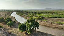
File:Blue Nile Falls-03, by CT Snow.jpg|Kira River waterfall in the Maya Rift Valley | |||
</gallery> | |||
==Government and politics== | |||
===Heads of power=== | |||
The Kembesan government is a federal constitutional monarchy. In 1936, the new constitution introduced a bicameral parliament and limited separation of powers between the executive, judiciary, and legislature. The constitution also introduced divisions of power between the federal/imperial and subnational levels, though the imperial government maintains significant residual power. | |||
== | ====Federal government==== | ||
=== | The Emperor of Kembesa is a monarch who exercises significant executive powers, largely via the power to issue decrees. As part of this function, the monarch appoints ministers to oversee different portfolios of the imperial government. The monarch is also required to give assent to any new laws for them to be enacted. In addition to temporal authority, the monarch has significant influence over the Azdarin faith in the country. | ||
The | [[File:Montaza Palace 008.JPG|right|thumb|300x300px|Imperial palace in Azwa]] | ||
The upper house of parliament is the Noble Assembly. The Noble Assembly is composed of noble representatives from each of the four constituent nations who act primarily in a consultative role and have limited authority to pass legislation. The Noble Assembly is also responsible for confirming federal court appointments and can oversee commissions and inquiries. While the Noble Assembly has the power to refer legislation from the Popular Assembly for judicial review, it has no power to reject its legislation. There are 35 nobles from Meharia, 15 nobles from Masara, 11 nobles from Janubia, 10 nobles from Degama, and 12 Azdarin clerics appointed by the Emperor for a total of 83 seats. | |||
The | The lower house of parliament is the Popular Assembly. The Popular Assembly is the main deliberative assembly at the federal level in Kembesa. It has the main power to draft and pass laws. In addition, the chancellor is conventionally appointed from the leading party of the Popular Assembly and is recognized as the leader of the legislature, ostensibly with a customary consultative role for the monarch. The Popular Assembly is made up of 82 representatives from Meharia, 24 representatives from Degama, 20 representatives from Janubia, and 11 representatives from Masara for a total of 137 representatives. Kembesa has universal suffrage, though individuals must own property to stand for election. Federal elections occur every five years with no term limits and use a {{wp|first-past-the-post}} system. | ||
The | ====Subnational governments==== | ||
The monarchical governments of the four subnational governments each maintain unique structures over their respective subnations. The main subnational powers include local infrastructure, education, and the administration and composition of local courts. | |||
In the case of Meharia, the Yematid dynasty controls both the imperial and local governments. In practice, the Crown Prince customarily exercises the role of the monarch in Meharia, which has a unicameral assembly for local legislation. In Janubia, the king appoints a governor, known as a ''wasiir'' to manage each of the 11 districts, with no subnational legislature. The Duchy of Masara has largely devolved its powers to the municipal level. In the Principality of Degama, the prince has an essentially ceremonial role with most authority devolved to the bicameral Parliament of Degama which elects a prime minister. | |||
===Law=== | ===Law=== | ||
Kembesan law is a patchwork of customary, religious, and statutory laws. | Kembesan law is a patchwork of customary, religious, and statutory laws. Imperial edicts and bills passed since 1930 form the basis of the statutory regime which applies across the empire, mostly in the domain of administrative law, criminal law, and employment law. National laws passed and pronounced by the constituent nations cover most property laws, regulatory laws, and tort law. Customary law in Kembesa is unwritten and specific to each constituent nation. In these areas, the court system has generally preserved local traditions and Azdarin religious values rather than imposing a single law across the Empire. The interpretation of Kembesan customary law relies primarily on precedent which was formalized under a system of common law in the 1930 constitution. | ||
The highest court in Kembesa is the Imperial Court of Justice, which is both a court of cassation for the lower federal courts and a first instance court for constitutional questions and reviews from the Imperial Parliament. Below the Imperial Court of Justice, there are four Lesser Imperial Courts which have plenary jurisdiction over federal matters. Each constituent nation of Kembesa has its own court system with plenary lower courts, superior courts, and courts of cassation. | |||
===Administrative | ===Administrative subdivisions=== | ||
{|class="wikitable" | |||
|- | |||
! Flag | |||
! Nation | |||
! Capital | |||
! Executive | |||
! Legislature | |||
! Popular</br>Assembly | |||
! Districts | |||
! Population<br>(2024) | |||
! Area</br>(km{{sup|2}}) | |||
|- | |||
| align="center"| [[file:Flag of Meharia.png|75px]] | |||
| [[Meharia]] | |||
| [[Azwa]] | |||
| [[Hailu, Crown Prince of Kembesa|Hailu Yemata]]<br><small>Crown Prince of Meharia</small> | |||
| align="center"| Royal Assembly</br>of Meharia | |||
| align="center"| 82 | |||
| align="center"| 35 | |||
| align="right"| 15,552,976 | |||
| align="right"| 338,505 | |||
|- | |||
| align="center"| [[file:Flag of Janubia.png|75px]] | |||
| [[Janubia]] | |||
| [[Xawiliye]] | |||
| [[Cali IX of Janubia|Cali Madar IX Gurey]]<br><small>King of Janubia</small> | |||
| align="center"| ''N/A'' | |||
| align="center"| 20 | |||
| align="center"| 11 | |||
| align="right"| 6,776,870 | |||
| align="right"| 107,530 | |||
|- | |||
| align="center"| [[file:Flag of Degama.png|75px]] | |||
| [[Degama]] | |||
| [[Aradam]] | |||
| [[Zenawi V of Degama|Zenawi V Zemaya]]<br><small>Prince of Degama</small> | |||
| align="center"| Parliament of</br>Degama | |||
| align="center"| 24 | |||
| align="center"| 10 | |||
| align="right"| 7,873,314 | |||
| align="right"| 116,385 | |||
|- | |||
| align="center"| [[file:Flag of Masara.png|75px]] | |||
| [[Masara]] | |||
| [[Hawas]] | |||
| [[Hacalu III of Masara|Hacalu III Yebira]]<br><small>Ras Masara</small> | |||
| align="center"| ''N/A'' | |||
| align="center"| 11 | |||
| align="center"| 15 | |||
| align="right"| 4,881,171 | |||
| align="right"| 102,796 | |||
|} | |||
===Military=== | ===Military=== | ||
The Kembesan Imperial Army and the Kembesan Imperial Navy are the two branches of the Kembesan military. Each branch has an independent air wing – a consequence of reorganizational compromises in 1953. The Imperial Army receives the bulk of funding and counts approximately 200,000 active service personnel and 120,000 reservists. The Imperial Navy has 30,000 active service personnel and the same number of reservists and civilian workers. Conscription is mandatory for non-exempt 18-year-olds for a period of 9-18 months. | |||
<gallery widths="280"> | |||
File:TanksRoad3a.jpg|Imperial Army column of [[BMS Parmenio MBT|Parmenio main battle tanks]] | |||
File:Emb326 Brazil (16539417497).jpg|{{wp|Aermacchi MB-326|BTA 326 light attack aircraft}} of the IA Air Wing | |||
File:Arg 902.jpg|{{wp|Koni-class frigate|''Ketema''-class frigate}} of the Imperial Navy | |||
</gallery> | |||
==Economy== | ==Economy== | ||
Kembesa has a | Kembesa has a {{Wp|dual economy}}, with a major divide between extractive and manufacturing centres with traditional subsistence activities. Extractive industries are based predominantly on mining for precious stones, copper, and platinoid metals. Cash crops such as tea and coffee are also economically important, and have overlap with subsistence farming for rice and cereals. However, inconsistency in cash crop output has had a negative impact on the Kembesan export economy. Since 1930, Kembesa's economy has increasingly industrialized with a growing focus on manufacturing which has bolstered the national gross domestic product. Beginning in the 1980s, the country also began to exploit a small offshore natural gas field off the coast of Janubia. | ||
Kembesa has developed a small-scale market in East Scipia for manufacturing consumer goods, excluding small electronics due to a lack of infrastructure for transistor manufacturing. Over the past decade, economic growth has stagnated but thus far an outright crash or recession has been averted. Present-day challenges include an insufficient electricity grid and barriers to movement. Income inequality is high with the vast majority of wealth concentrated with a small segment of the population. | |||
===Agriculture=== | ===Agriculture=== | ||
Nearly 75% of Kembesa's area is used for horticulture and arboriculture. Between 20 and 30 percent of Kembesans maintain a way of life which is similar to how serfs lived pre-1936, albeit as agricultural renters rather than as servants. Subsistence farming and commercial food production are major activities along with cash crop production. Due to the large but fluctuating degree to which subsistence farming plays a role in the economy, disentangling different agricultural activies and their proportions in the agricultural sector is virtually impossible. | |||
Common staple crops include cereals but also large scale vegetable and fruit operations. Major cash crops include coffee and tea. Livestock agriculture is less dominant than plant-based industry but plays an important subsistence role. Common livestocks include cows but farms gradually transition southward from Fahran to M'biruna. | |||
===Transportation=== | |||
In Kembesa, roads are administered at the ''woreda''-level and vary in quality and maintenance, particularly in rural Kembesa and in parts of Masara where paving is uncommon. Several ''woredas'' require tolls for access while others are funded through local taxation. | |||
Rail travel is managed by the three regions but is administered by a single state corporation; the Imperial Kembesan Rail Company. The IKRC was established by the 1936 constitution which unified several existing rail networks which were operated by the constituent nations of Kembesa. Travel by rail is often cheaper than road travel but is inefficient. Trains are frequently delayed by as long as 12 hours, certain corridors maybe be closed by maintenance or seasonal flooding, and the IKRC's railcars are antiquated by modern standards. | |||
Kembesa has major ports in Xawiliye and Kima; both in Janubia. The Kira River is also a major route for waterborne travel and transportation from Degama and Meharia northward. The nation has three international airports. The largest is in the capital of Azwa with secondary hubs in Aradam and Xawiliye. Regular air routes in and out of Kembesa include Haqara, Bemiritra, Adijan, Jegurjur, Perivolia, and Ikaria. Charter flights are also often available. | |||
==Demographics== | ==Demographics== | ||
===Language=== | ===Language=== | ||
| Line 208: | Line 266: | ||
===Healthcare and education=== | ===Healthcare and education=== | ||
==Art and culture== | |||
=== | ===Cuisine=== | ||
===Sports=== | ===Sports and leisure=== | ||
[[Category:Ajax]] | [[Category:Ajax]] | ||
Latest revision as of 03:29, 25 July 2024
This article is incomplete because it is pending further input from participants, or it is a work-in-progress by one author. Please comment on this article's talk page to share your input, comments and questions. Note: To contribute to this article, you may need to seek help from the author(s) of this page. |
Empire of Kembesa | |
|---|---|
 Flag
 Coat of arms
| |
| Anthem: March Forward, Kembesa! | |
 Map of Kembesa | |
| Capital | Azwa |
| Official languages | Meharic |
| Recognised national languages | Degamic Masaric Janubic |
| Recognised regional languages | Gharbaic Dardaloni M'bweni |
| Demonym(s) | Kembesan |
| Government | Federal constitutional monarchy |
• Emperor | Hailu II Yemata |
• Chancellor | Tesfaldet Woldemesfin† |
| Legislature | Imperial Parliament |
| Noble Assembly | |
| Popular Assembly | |
| Establishment | |
• Yematid Kingdom of Meharia | June 28, 1858 |
• Empire of Kembesa | September 19, 1930 |
• Constitutional monarchy | October 23, 1936 |
| Area | |
• Total | 665,216 km2 (256,841 sq mi) |
• Water (%) | 0.92 |
| Population | |
• 2024 census | 35,084,331 |
• Density | 52.74/km2 (136.6/sq mi) |
| GDP (nominal) | estimate |
• Total | $655 billion (2024) |
• Per capita | $18,672.02 |
| Gini (2024) | very high |
| HDI (2024) | high |
| Currency | Werik ( |
| Calling code | +530 |
The Empire of Kembesa is a nation in East Scipia. It is bordered to the northeast by Fahran, the northwest by Charnea, and the southwest by M'biruna. The imperial capital of Kembesa is the city of Azwa, which is also the capital of the Kingdom of Meharia.
Kembesa is ostensibly a confederation of four nations ruled by the Yematid dynasty including the core Kingdom of Meharia, the Principality of Degama, the Duchy of Masara, and the Kingdom of Janubia. The term “Kembesa” has historically been associated with the region south of Fahran, beyond the borders of the Zahra Desert and before M'biruna. The name "Kembesa" roughly translates to “Land of the Lions” in the ancient She’dje language of the region.
The modern state of Kembesa was founded in 1930 after over 70 years of military expansion. The Kembesan constitution was introduced in 1936 following significant clamour for reform and liberalization. Each constituent nation has maintained a degree of local autonomy under the constitution, though the imperial government maintains supreme authority over the subnational and district governments.
Economically, most of Kembesa has successfully industrialized despite continued wealth inequality. One of the greatest issues is power as the early-20th century power grid is both aging and inadequate to sustain the demand of the population which has increased rapidly over the past hundred years. Geographically, Kembesa has a varied topography with hills and desert in the north, river basins in the east, and rainforests in the far south.
History
The earliest material evidence of human habitation in Kembesa dates to approximately 2700 BCE. The first central state of the region was the Kingdom of Ke'sem, founded in the mid-10th century BCE. Through much of antiquity, however, the region was unstable, with a number of competing tribal confederations vying for control over the region. By the mid first millennium BCE, the rival kingdoms of Melewa and Yebwi exercised significant control over the region.

Kembesa is perhaps best known as the birthplace of Mesfin, the warrior-king and founder of the Azdarin faith. Born sometime in the mid-10th century CE, Mesfin was the adopted son of a regional Mehari chief who was guided by the seeress Amsalech an appointed as the chosen of Gedayo. Mesfin became the leader of an army of freed slaves and conquered the kingdoms of Kembesa to found a new theocratic state. Mesfin died in 985 CE and his empire dissolved. However, Gharib followers of Mesfin to the north of Kembesa carried on in his name and founded the Almurid Caliphate in 993 CE. The Caliphate expanded across Scipia and continued to occupy Kembesa until the Ihemodian conquests of the 14th century. Ihemod ultimately died on campaign in Kembesa, but the Caliphate was never reunifed and the region of Kembesa was divided between a number of kingdoms again, though the Azdarin faith remained strong in the region.
The Yematid dynasty came to power in the Kingdom of Meharia in 1858, beginning a war of expansion that resulted in the conquests of Degama in 1864 and Masara in 1879. The Kingdom of Janubia was conquered by Meharia during the chaos of the Hanaki War in 1930, following which King Mengesha III Yemata proclaimed the Empire of Kembesa. Clamour for reform lead swiftly to liberalization and national reorganization with the introduction of a constitution in 1936.
Geography and climate
Kembesa has four approximate geographic regions. These are the eastern reaches of the Zahra desert in the country's northwest; the Mesewi Mountains, a series of low mountains, including the important holy site of Nutum Inyaru; and the eastern coast region which includes the Kumanaan Archipelago, the largest island of which is Bariga Island.

In terms of climate, Kembesa experiences a range of climates between the hot arid desert in the northwest and the more temperate Periclean climate type in the east. The Zahra desert has very elevated temperatures and little average precipitation over the course of a year. While less extreme than the bulk of the desert to the west, it is not uncommon for the desert to see under 10 mm of precipitation over the course of a year. The Mesewi Mountains and the eastern coast are broadly characterized as semi-arid to savannah, experiencing elevated temperatures and a dry and wet seasonal cycle. Shrublands and small patches of woodlands are common, particularly around rivers that run through these regions.

Sparse vegetation in the Zahra

Dry season in the Mesewi Mountains
Wet season shrublands on the Janubi Coast

Kira River waterfall in the Maya Rift Valley

.jpg)


Government and politics
Heads of power
The Kembesan government is a federal constitutional monarchy. In 1936, the new constitution introduced a bicameral parliament and limited separation of powers between the executive, judiciary, and legislature. The constitution also introduced divisions of power between the federal/imperial and subnational levels, though the imperial government maintains significant residual power.
Federal government
The Emperor of Kembesa is a monarch who exercises significant executive powers, largely via the power to issue decrees. As part of this function, the monarch appoints ministers to oversee different portfolios of the imperial government. The monarch is also required to give assent to any new laws for them to be enacted. In addition to temporal authority, the monarch has significant influence over the Azdarin faith in the country.

The upper house of parliament is the Noble Assembly. The Noble Assembly is composed of noble representatives from each of the four constituent nations who act primarily in a consultative role and have limited authority to pass legislation. The Noble Assembly is also responsible for confirming federal court appointments and can oversee commissions and inquiries. While the Noble Assembly has the power to refer legislation from the Popular Assembly for judicial review, it has no power to reject its legislation. There are 35 nobles from Meharia, 15 nobles from Masara, 11 nobles from Janubia, 10 nobles from Degama, and 12 Azdarin clerics appointed by the Emperor for a total of 83 seats.
The lower house of parliament is the Popular Assembly. The Popular Assembly is the main deliberative assembly at the federal level in Kembesa. It has the main power to draft and pass laws. In addition, the chancellor is conventionally appointed from the leading party of the Popular Assembly and is recognized as the leader of the legislature, ostensibly with a customary consultative role for the monarch. The Popular Assembly is made up of 82 representatives from Meharia, 24 representatives from Degama, 20 representatives from Janubia, and 11 representatives from Masara for a total of 137 representatives. Kembesa has universal suffrage, though individuals must own property to stand for election. Federal elections occur every five years with no term limits and use a first-past-the-post system.
Subnational governments
The monarchical governments of the four subnational governments each maintain unique structures over their respective subnations. The main subnational powers include local infrastructure, education, and the administration and composition of local courts.
In the case of Meharia, the Yematid dynasty controls both the imperial and local governments. In practice, the Crown Prince customarily exercises the role of the monarch in Meharia, which has a unicameral assembly for local legislation. In Janubia, the king appoints a governor, known as a wasiir to manage each of the 11 districts, with no subnational legislature. The Duchy of Masara has largely devolved its powers to the municipal level. In the Principality of Degama, the prince has an essentially ceremonial role with most authority devolved to the bicameral Parliament of Degama which elects a prime minister.
Law
Kembesan law is a patchwork of customary, religious, and statutory laws. Imperial edicts and bills passed since 1930 form the basis of the statutory regime which applies across the empire, mostly in the domain of administrative law, criminal law, and employment law. National laws passed and pronounced by the constituent nations cover most property laws, regulatory laws, and tort law. Customary law in Kembesa is unwritten and specific to each constituent nation. In these areas, the court system has generally preserved local traditions and Azdarin religious values rather than imposing a single law across the Empire. The interpretation of Kembesan customary law relies primarily on precedent which was formalized under a system of common law in the 1930 constitution.
The highest court in Kembesa is the Imperial Court of Justice, which is both a court of cassation for the lower federal courts and a first instance court for constitutional questions and reviews from the Imperial Parliament. Below the Imperial Court of Justice, there are four Lesser Imperial Courts which have plenary jurisdiction over federal matters. Each constituent nation of Kembesa has its own court system with plenary lower courts, superior courts, and courts of cassation.
Administrative subdivisions
| Flag | Nation | Capital | Executive | Legislature | Popular Assembly |
Districts | Population (2024) |
Area (km2) |
|---|---|---|---|---|---|---|---|---|
| Meharia | Azwa | Hailu Yemata Crown Prince of Meharia |
Royal Assembly of Meharia |
82 | 35 | 15,552,976 | 338,505 | |
| Janubia | Xawiliye | Cali Madar IX Gurey King of Janubia |
N/A | 20 | 11 | 6,776,870 | 107,530 | |
| Degama | Aradam | Zenawi V Zemaya Prince of Degama |
Parliament of Degama |
24 | 10 | 7,873,314 | 116,385 | |
| Masara | Hawas | Hacalu III Yebira Ras Masara |
N/A | 11 | 15 | 4,881,171 | 102,796 |
Military
The Kembesan Imperial Army and the Kembesan Imperial Navy are the two branches of the Kembesan military. Each branch has an independent air wing – a consequence of reorganizational compromises in 1953. The Imperial Army receives the bulk of funding and counts approximately 200,000 active service personnel and 120,000 reservists. The Imperial Navy has 30,000 active service personnel and the same number of reservists and civilian workers. Conscription is mandatory for non-exempt 18-year-olds for a period of 9-18 months.

Imperial Army column of Parmenio main battle tanks

BTA 326 light attack aircraft of the IA Air Wing

Ketema-class frigate of the Imperial Navy

.jpg)

Economy
Kembesa has a dual economy, with a major divide between extractive and manufacturing centres with traditional subsistence activities. Extractive industries are based predominantly on mining for precious stones, copper, and platinoid metals. Cash crops such as tea and coffee are also economically important, and have overlap with subsistence farming for rice and cereals. However, inconsistency in cash crop output has had a negative impact on the Kembesan export economy. Since 1930, Kembesa's economy has increasingly industrialized with a growing focus on manufacturing which has bolstered the national gross domestic product. Beginning in the 1980s, the country also began to exploit a small offshore natural gas field off the coast of Janubia.
Kembesa has developed a small-scale market in East Scipia for manufacturing consumer goods, excluding small electronics due to a lack of infrastructure for transistor manufacturing. Over the past decade, economic growth has stagnated but thus far an outright crash or recession has been averted. Present-day challenges include an insufficient electricity grid and barriers to movement. Income inequality is high with the vast majority of wealth concentrated with a small segment of the population.
Agriculture
Nearly 75% of Kembesa's area is used for horticulture and arboriculture. Between 20 and 30 percent of Kembesans maintain a way of life which is similar to how serfs lived pre-1936, albeit as agricultural renters rather than as servants. Subsistence farming and commercial food production are major activities along with cash crop production. Due to the large but fluctuating degree to which subsistence farming plays a role in the economy, disentangling different agricultural activies and their proportions in the agricultural sector is virtually impossible.
Common staple crops include cereals but also large scale vegetable and fruit operations. Major cash crops include coffee and tea. Livestock agriculture is less dominant than plant-based industry but plays an important subsistence role. Common livestocks include cows but farms gradually transition southward from Fahran to M'biruna.
Transportation
In Kembesa, roads are administered at the woreda-level and vary in quality and maintenance, particularly in rural Kembesa and in parts of Masara where paving is uncommon. Several woredas require tolls for access while others are funded through local taxation.
Rail travel is managed by the three regions but is administered by a single state corporation; the Imperial Kembesan Rail Company. The IKRC was established by the 1936 constitution which unified several existing rail networks which were operated by the constituent nations of Kembesa. Travel by rail is often cheaper than road travel but is inefficient. Trains are frequently delayed by as long as 12 hours, certain corridors maybe be closed by maintenance or seasonal flooding, and the IKRC's railcars are antiquated by modern standards.
Kembesa has major ports in Xawiliye and Kima; both in Janubia. The Kira River is also a major route for waterborne travel and transportation from Degama and Meharia northward. The nation has three international airports. The largest is in the capital of Azwa with secondary hubs in Aradam and Xawiliye. Regular air routes in and out of Kembesa include Haqara, Bemiritra, Adijan, Jegurjur, Perivolia, and Ikaria. Charter flights are also often available.