User:Norcandy/Sandbox/Port Hope: Difference between revisions
No edit summary |
No edit summary |
||
| Line 11: | Line 11: | ||
| perrow = 1/2/1/2 | | perrow = 1/2/1/2 | ||
| image1 = Skylines of Brisbane in winter misty morning seen from Kangaroo Point, Queensland 04.jpg | | image1 = Skylines of Brisbane in winter misty morning seen from Kangaroo Point, Queensland 04.jpg | ||
| image2 = | | image2 = Sydney StMaryCathedral perspective.JPG | ||
| image3 = Auckland War Memorial Museum, 2016-01-21.jpg | | image3 = Auckland War Memorial Museum, 2016-01-21.jpg | ||
| image4 = | | image4 = Sydney Opera House, botanic gardens 1.jpg | ||
| image5 = National Library of New Zealand Wellington 2015 (cropped).jpg | | image5 = National Library of New Zealand Wellington 2015 (cropped).jpg | ||
| image6 = Uniegebou.jpg | | image6 = Uniegebou.jpg | ||
}} | }} | ||
| image_alt = | | image_alt = | ||
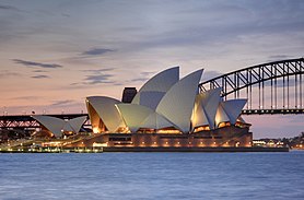
| image_caption = Clockwise from top: Skyline from Hawke Mound; National War Museum; | | image_caption = Clockwise from top: Skyline from Hawke Mound; National War Museum; Port Hope Opera House and Sandy Cove Bridge; Parliament Buildings; National Archives & Library; St Patrick's Cathedral | ||
| image_flag = [[File:Flag of the National Capital District.png|150px]] | | image_flag = [[File:Flag of the National Capital District.png|150px]] | ||
| flag_alt = | | flag_alt = | ||
| Line 105: | Line 105: | ||
| postal_code = {{collapsible list | | postal_code = {{collapsible list | ||
| titlestyle = background:transparent;text-align:left;font-weight:normal; | | titlestyle = background:transparent;text-align:left;font-weight:normal; | ||
| title = | | title = 13 postcodes | ||
| | | NE1, NE2, NE3, NE4, SC1, SC2, SC3, SC4, SC5, SC6, SC7, SC8, SC9}} | ||
| area_code_type = | | area_code_type = | ||
| area_code = | | area_code = | ||
| Line 114: | Line 114: | ||
}} | }} | ||
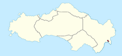
'''Port Hope''' is the {{wpl|Capital city}} of [[Satavia]] and the [[Port Hope|National Capital District]], a federal territory within Satavia containing only the unitary authority of Port Hope. With a population of 2.4 million inhabitants, Port Hope is the most populous city in Satavia and also the oldest continually inhabited settlement on the island. Port Hope is located around [[Dolfynbaai]] and is situated at the mouth of the [[River Pelham]]. From the early 19th century the docks at [[Breybach Sands]] were some of the largest in the Asterias, before they slowly fell out of use as larger ships were unable to navigate the shallow waters at the mouth of Dolfynbaai, and by the late 20th century they had been made entirely redundant. | '''Port Hope''' is the {{wpl|Capital city}} of [[Satavia]] and the [[Port Hope|National Capital District]], a federal territory within Satavia containing only the unitary authority of Port Hope. With a population of 2.4 million inhabitants, Port Hope is the most populous city in Satavia and also the oldest continually inhabited settlement on the island. Port Hope is located around [[Dolfynbaai]] and is situated at the mouth of the [[River Pelham]]. From the early 19th century the docks at [[Breybach Sands]] were some of the largest in the [[Asteria Inferior|Asterias]], before they slowly fell out of use as larger ships were unable to navigate the shallow waters at the mouth of Dolfynbaai, and by the late 20th century they had been made entirely redundant. | ||
Port Hope was founded as 'Nieuwe Zilverzee' on the 22 August, 1541 by the Hennish explorer [[Jan van Breybach]], who was the first Euclean to successfully navigate the [[Van Horn Straight]]. By 1590, the town had become known as 'Zanderig Inham', meaning 'Sandy Cove'. By 1747, Sandy Cove was by far the largest settlement on the island of Satavia and was the capital of the [[Dolfynbaai Kolonie]], the largest of the Satavian colonies. | Port Hope was founded as 'Nieuwe Zilverzee' on the 22 August, 1541 by the Hennish explorer [[Jan van Breybach]], who was the first Euclean to successfully navigate the [[Van Horn Straight]]. By 1590, the town had become known as 'Zanderig Inham', meaning 'Sandy Cove'. By 1747, Sandy Cove was by far the largest settlement on the island of Satavia and was the capital of the [[Dolfynbaai Kolonie]], the largest of the Satavian colonies. Sandy Cove was chosen as the new capital of the [[Dominion of Satavia]] when [[Dominion of Satavia|the federation of Satavia]] was achieved in 1816. The city grew in size throughout the 19th century. Sandy Cove began to refer only to the bay area of the city, whilst the name Port Hope became more commonplace. In 1895 the city was officially renamed Port Hope, in honour of [[Richard Hope, Earl of Longwood]], who was born in the city. | ||
The city's population skyrocketed during the [[Great Collapse (Kylaris)|Great Collapse]] as many Satavians moved away from rural areas in search of jobs and opportunities. By 1927, Port Hope was arguably the most advanced city in [[Asteria Inferior]]. The [[Port Hope Underground]], first opened in 1899, was the most advanced rapid transport network in Asteria Inferior and was based heavily on [[Morwall|Morwall's]] transit network. During the [[Defence of Port Hope]], much of the city was damaged and destroyed including most of [[Port Hope Castle]], a 17th century fortress in the centre of Port Hope, which was left in ruins until 1985, when the process of demolition began. The city is internationally recognisable by it's [[Port Hope Opera House|Opera House]] and [[Port Hope|Sandy Cove Bridge]]. | |||
The [[Satavia Act, 1999]] split Port Hope in half, with the area now known as [[Burnaby]] remaining in the Hope Province, whilst Port Hope became part of the newly formed [[Port Hope|National Capital District]]. The city is home to the National Capital District legislative council, the [[Parliament of Satavia]], [[Government House, Port Hope]], [[The Residence, Port Hope]], the [[Port Hope|National War Museum]], [[Port Hope|St Patrick's Cathedral]], [[Port Hope Opera House]] and [[Port Hope|Sandy Cove Bridge]]. Port Hope is also home to the [[Port Hope Stock Exchange]] and one of Asteria's oldest universities, [[University College Port Hope]] as well as various other academic institutions. The city is ranked highly in the [[World City Studies Institute]] as a [[World City Studies Institute|Tier 2 city]]. Today, Port Hope and Burnaby boast the highest living standard in western Asteria Inferior and the highest in Satavia. | |||
Latest revision as of 13:03, 27 July 2022
Port Hope
| |
|---|---|
Clockwise from top: Skyline from Hawke Mound; National War Museum; Port Hope Opera House and Sandy Cove Bridge; Parliament Buildings; National Archives & Library; St Patrick's Cathedral | |
| Etymology: Named for Richard Hope, Earl of Longwood | |
| Nickname(s): Old Town; Sandy Cove | |
| Motto(s): Primum sibi ac Fidelissimum Estmerish: First and Most Loyal | |
 National Capital District (NCD) in red | |
| Country | |
| Territory | National Capital District |
| Founded | 22 August, 1541 |
| Founded by | Jan van Breybach |
| Legislature | National Capital District Council |
| Government | |
| • Governor | Christopher Marshall |
| • Administrator | office vacant |
| • Mayor | Arthur Greenhouse (LIB) |
| Area | |
| • Total | 336 km2 (130 sq mi) |
| Population (2018) | |
| • Total | 2,421,671 |
| • Density | 7,200/km2 (19,000/sq mi) |
| Time zone | UTC+11 (Satavian Standard Time) |
| Post codes | 13 postcodes
|
| Website | ncd |
Port Hope is the Capital city of Satavia and the National Capital District, a federal territory within Satavia containing only the unitary authority of Port Hope. With a population of 2.4 million inhabitants, Port Hope is the most populous city in Satavia and also the oldest continually inhabited settlement on the island. Port Hope is located around Dolfynbaai and is situated at the mouth of the River Pelham. From the early 19th century the docks at Breybach Sands were some of the largest in the Asterias, before they slowly fell out of use as larger ships were unable to navigate the shallow waters at the mouth of Dolfynbaai, and by the late 20th century they had been made entirely redundant.
Port Hope was founded as 'Nieuwe Zilverzee' on the 22 August, 1541 by the Hennish explorer Jan van Breybach, who was the first Euclean to successfully navigate the Van Horn Straight. By 1590, the town had become known as 'Zanderig Inham', meaning 'Sandy Cove'. By 1747, Sandy Cove was by far the largest settlement on the island of Satavia and was the capital of the Dolfynbaai Kolonie, the largest of the Satavian colonies. Sandy Cove was chosen as the new capital of the Dominion of Satavia when the federation of Satavia was achieved in 1816. The city grew in size throughout the 19th century. Sandy Cove began to refer only to the bay area of the city, whilst the name Port Hope became more commonplace. In 1895 the city was officially renamed Port Hope, in honour of Richard Hope, Earl of Longwood, who was born in the city.
The city's population skyrocketed during the Great Collapse as many Satavians moved away from rural areas in search of jobs and opportunities. By 1927, Port Hope was arguably the most advanced city in Asteria Inferior. The Port Hope Underground, first opened in 1899, was the most advanced rapid transport network in Asteria Inferior and was based heavily on Morwall's transit network. During the Defence of Port Hope, much of the city was damaged and destroyed including most of Port Hope Castle, a 17th century fortress in the centre of Port Hope, which was left in ruins until 1985, when the process of demolition began. The city is internationally recognisable by it's Opera House and Sandy Cove Bridge.
The Satavia Act, 1999 split Port Hope in half, with the area now known as Burnaby remaining in the Hope Province, whilst Port Hope became part of the newly formed National Capital District. The city is home to the National Capital District legislative council, the Parliament of Satavia, Government House, Port Hope, The Residence, Port Hope, the National War Museum, St Patrick's Cathedral, Port Hope Opera House and Sandy Cove Bridge. Port Hope is also home to the Port Hope Stock Exchange and one of Asteria's oldest universities, University College Port Hope as well as various other academic institutions. The city is ranked highly in the World City Studies Institute as a Tier 2 city. Today, Port Hope and Burnaby boast the highest living standard in western Asteria Inferior and the highest in Satavia.


