Portal:Kylaris/Features: Difference between revisions

Jump to navigation Jump to search
No edit summary
No edit summary
 
(17 intermediate revisions by 3 users not shown)
Line 1: Line 1:
<div style="float:left;margin:0.5em 0.9em 0.4em 0;">{{Region icon Kylaris}}</div>
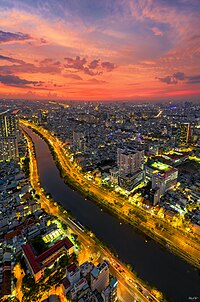
[[File:DJI_0196-HDR-Pano.jpg|right|thumb|200px|An evening view of a canalised tributary of the Buiganhingi as it flows through Naimhejia, the second biggest city in Dezevau]]
[[File:SattarishahrMontage.png|thumb|200px|From clockwise top left; the [[Mahrdad Ali Sattari Monument]], [[Sattarishahr Garden]], [[Avenue of the Union]], [[Mausoleum of the Union Fathers]] and [[Mahyar Vaziri Grand Mazar]]]]
'''Urban planning in Dezevau''' is the planning and design of cities in [[Dezevau]]. It has a history that stretches back two thousand years or more, though modern urban planning only emerged after Dezevauni independence in 1941. It is a key academic, governmental and political concern, influenced strongly in the present day by the nature of local and federal power, and by the ideal of a democratic and socialist economy; its importance relates to the high level of urbanisation in Dezevau, which is about 70%. The most significant urban planning agencies are the district planning commissions, but like many other political processes in Dezevau, consultation with and input from both higher and lower governmental strata are crucial.  
'''Sattarishahr''' ({{wp|Persian language|Pasdani}}: ساتاریستی, solarianised: Sattārishahr) is the capital city of [[Zorasan]] and is governed by the Zorasani federal government through the [[Union Capital District]], which encompasses the city and its surrounding environs. Initially built as a {{wp|planned city}} within the Tinnin Plateau region to support population growth in the 2000s, it was proclaimed the new capital in 2016 replacing [[Zahedan]] as the nation's capital. It is the Xth largest city in Zorasan. The city has consistently topped national rankings for high standards of living, public safety, cleanliness, greenery and transportation.
('''[[Urban planning in Dezevau|See more...]]''')
 
Sattarishahr was originally planned as a {{wp|new city}} to ease pressure on the then capital, [[Zahedan]]. However, the congestion of Zahedan, coupled with a desire to reduce the logistical burden on the city resulted in the government deciding to use the existing plans to construct a new capital. The master plan was designed by Zorasani architects, [[Hamid Ali Shabestari]] and [[Farhad Hadadifar]] and divides the city into nine zones, including government, a diplomatic quarter, residential, commercial, cultural, educational and industrial. A significant focus of the masterplan was placed on green spaces, a reduction in density of buildings and integration with nature. The 2010 decision for the new city to become the capital was followed by alterations to the masterplan, which now included space for national monuments and a enlarged government zone. Construction of the city also included the establishment of a new national park encompassing the Abolkhayr foothills of the Tinin Mountains, and the construction of an artificial lake in the heart of the city. The city includes landmarks such as the [[Mausoleum of the Union Fathers]], [[Mahrdad Ali Sattari Monument]], [[Sardar Javad Jahandar Culture Centre]], [[Sattarishahr Garden Conference Hall]] and the [[Mahyar Vaziri Grand Mazar]], the world’s fifth largest Mazar.
 
Sattarishahr is ranked as Beta+ city and is noted for its high cost of living, with an overwhelming majority of the city's population being of the middle and upper classes. Emigration to the city is severely restricted, to preserve the city's open spaces and quality of life. The vast majority of its citizens are employees of the government institutions and agencies based in the city, leading many commenators to claim its population is near entirely comprised of members of the ruling [[National Renovation Front]] and loyal government workers.
('''[[Sattarishahr|See more...]]''')


<div style="text-align:right>[[File:KylarisRecognitionAchievement.png|25px]] '''{{cl|Kylaris Articles of Recognition|See all articles of recognition}}'''</div>
<div style="float:left;margin:0.5em 0.9em 0.4em 0;">{{Region icon Kylaris}}</div>

Latest revision as of 23:38, 1 March 2024

An evening view of a canalised tributary of the Buiganhingi as it flows through Naimhejia, the second biggest city in Dezevau

Urban planning in Dezevau is the planning and design of cities in Dezevau. It has a history that stretches back two thousand years or more, though modern urban planning only emerged after Dezevauni independence in 1941. It is a key academic, governmental and political concern, influenced strongly in the present day by the nature of local and federal power, and by the ideal of a democratic and socialist economy; its importance relates to the high level of urbanisation in Dezevau, which is about 70%. The most significant urban planning agencies are the district planning commissions, but like many other political processes in Dezevau, consultation with and input from both higher and lower governmental strata are crucial. (See more...)
KylarisRecognitionAchievement.png See all articles of recognition
Template:Region icon Kylaris