Mathral: Difference between revisions
Posadastan (talk | contribs) |
Posadastan (talk | contribs) |
||
| (51 intermediate revisions by the same user not shown) | |||
| Line 50: | Line 50: | ||
|GDP_nominal_per_capita = $8,903 | |GDP_nominal_per_capita = $8,903 | ||
|GDP_nominal_per_capita_rank = | |GDP_nominal_per_capita_rank = | ||
|HDI = 0. | |HDI = 0.764 | ||
|HDI_year = 2025 | |HDI_year = 2025 | ||
|time_zone = PST | |time_zone = PST | ||
| Line 60: | Line 60: | ||
}} | }} | ||
'''Mathral''', or the '''Federal Republic of Mathral''', is a small, isolated republic on the southern continent of [[Kaniq]] in [[Telrova]]. With its cold climate, rolling steppes and snowcapped mountains, the sparse population, centered primarily around a few coastal cities and islands, is made up primarily of indigenous Mathrali citizens, along with a mixture of neighboring and colonizing ethnic groups. | '''Mathral''', or the '''Federal Republic of Mathral''', is a small, geographically isolated republic on the southern continent of [[Kaniq]] in [[Telrova]]. With its cold climate, rolling steppes and snowcapped mountains, the sparse population, centered primarily around a few coastal cities and islands, is made up primarily of indigenous Mathrali citizens, along with a mixture of neighboring and colonizing ethnic groups. It is notable for being one of a few countries in Telrova to have a tricameral system of governance as well. | ||
The nation is bordered to the west by the Kingdom of Bathelonat and is bordered at sea by an island belonging to [[Socialist Platypus]]. The country is well-renowned for its landscapes and multicultural society. It is also one of the most sparsely populated countries on all of Telrova, with only 11.5 people per square kilometer (29.8 per sqmi). | The nation is bordered to the west by the Kingdom of Bathelonat and is bordered at sea by an island belonging to [[Socialist Platypus]]. The country is well-renowned for its landscapes and multicultural society. It is also one of the most sparsely populated countries on all of Telrova, with only 11.5 people per square kilometer (29.8 per sqmi). | ||
The nation also enjoys relative stability, having an unbroken chain of democracy since it was freed from colonial rule in | The nation also enjoys relative stability, having an unbroken chain of democracy since it was freed from colonial rule in 1921 (with the exception of minor anti-apartheid conflicts), and having few regional rivalries, with the exception of a dispute of the Tachinya Island with neighboring Bathelonat. It is defended by the [[Mathrali Defense Forces]] and has neutrality enshrined into its constitution. | ||
=Etymology= | =Etymology= | ||
The etymology of Mathral comes from contact with the Buyonese traders of the 16th through 18th centuries. The literal translation is "Mother Country" or "Mother Land". | |||
=History= | =History= | ||
===Pre-History=== | |||
The early history of Mathral saw the continent of Kaniq split from nearby Ost-Gershaft nearly 80 million years ago, where it drifted south towards its current location. | |||
In the several million years since, with the southward drift, the continent got continually colder, and much of the southern and eastern ends pushed up and slid against neighboring tectonic plates, creating vast mountain ranges and glacial coverage. Much of the nation today exists in the steppes, or rather flat environments brought about by vast glacial erosion, with much of the south and east being mountainous, and the Ngakwan river valley was also formed by glaciers and glacial melt/runoff, allowing for tons of grazing for the endemic wildlife. | |||
The region was also first home to human settlement around 6,000 years ago, as nomads and seafarers from Narushia and Pukam settled the western end of Kaniq. The nomadic peoples of this era slowly settled towards the east, inhabiting modern-day Mathral around 4,500-4,000BCE. During this time, many of the 8 modern tribes began to form, some taking to the mountains, some to the river valleys, and some to the steppes and deserts. | |||
{{Image frame|width=200|content=[[File:Cueva de las Manos (6811931046).jpg|200px]]|caption=Cave of the Hands, near Súeqwoto|align=left}} | |||
Most settlements remained fairly nomadic during this time, but some limited sedentarization began around 1,200-1,000BCE, with large mound-like structures and stone structures being constructed, as well as more complex communities and tools arising. Early pictographic scripts even arose during this era, though their use died out by the time of foreign contact. | |||
This led in turn to the more climactically stable coastal regions being more heavily populated, while more nomadic hunter-gatherer types stayed on the inland steppe regions. Meanwhile, intermediary pastoralist groups tended back and forth between the coasts and the inland steppes and mountains, often allowing for many of the merging cultures to mix quite often, which also meant the languages of the region were quite intermeshed with one another, often sharing much of the same vocabulary. | |||
= | ===Pre-colonization=== | ||
Around 500BCE was when contact with other groups in modern day AusValia and Bathelonat began to resume, as domesticated wildlife and some smaller shipbuilding allowed for more contact and intermingling along the northern coast of Kaniq. | |||
It was not until around 650CE however, that those not from Kaniq began to visit, opening up some very early trade and "discovery," including the early forms of the modern Mathrali script (which itself emerged around 1050CE). This period began to be known as the "5 Ports Period," where the various tribes fought and aligned with one another for control of one of the 5 strategic ports necessary for early trade. This period saw the establishment of many of the country's modern cities like Bochō, though some others weren't truly developed until later on. | |||
It was during the 5 Ports Period that many foreign tradesman, especially those from [[Buyo]] would begin to travel through and occasionally settle in these port areas, as well as establishing a tributary state to the Buyonese crown in the yet-uninhabited Bohwa Islands in ~1360CE. Around 1600CE, many of the tribes had established themselves as sovereign entities, most of whom traded primarily with one another or the Buyonese traders and settlers, who existed mostly in a peaceful way. | |||
This would lead to a 200-year long period known as the "Pax Buyonica" where all tribal kingdoms coexisted peaceful, with very little conflict. | |||
===Colonial Era=== | |||
Pax Buyonica ended in 1807, with the purchase of the Bohwa Islands by Ziromnian colonists who had sought a temperate- to cold-climate colony in the south of Telrova. Using the Bohwa islands as a base, many Ziromnian traders and colonists began to introduce themselves along the coast of modern day Mathral. This saw the eventual annexation of the 5 ports (Bochō, Atłun, Benīn, Swembatswa, and Vweqwoto) by the Ziromnian colonial forces in 1820, with many of the tribal kingdoms protesting and threatening to invade. The Ziromnians, armed with superior weapons and firepower managed to hold on to the ports despite multiple raids, and sent in waves of settlers over the next 3 decades, during which time they slowly conquered all 8 tribal kingdoms. | |||
{{Image frame|width=200|content=[[File:Italian immigrants buenos aires.jpg|200px]]|caption=Ziromnian immigrants arriving, 1902|align=left}} | |||
By 1834, the entirety of modern-day Mathral had been seized by Ziromnian colonists, and it was held under a rather strict colonial rule until 1908, when it was granted Dominionship, including the Bohwa Islands. Upon being granted the status of a dominion, the colony quickly consolidated rule amongst the Ziromnian settlers (27%), granting equal status to the Buyonese (9%), but a secondary status to the indigenous peoples (64%). | |||
This action at the time was not necessarily a controversial one on the international stage but did lead to an uprising by the indigenous Mathrali citizens who refused to have a second-class citizenship. This ultimately led to a civil war, beginning in 1909 after the murder of an indigenous activist in Bochō. This war was known as the "[[First Chimuregga]]", and lasted for 13 years until 1921, when the Ziromnian empire began to collapse, and decided to grant full independence to the dominion, under democratic rule, which upset the Ziromnian settlers, who after agreeing launched an immediate coup, nicknamed the [[Bochō Bonanza]] of 1922. | |||
With that came the "[[Second Chimuregga]]," which last from 1922 to 1969, or 47 years. Where the indigenous peoples fought to have equal representation and full voting rights, most often at the level of a low-level insurgency. | |||
{{Image frame|width=250|content=[[File:Estacion viedma deposito de coches.jpg|250px]]|caption=Bochō passenger rail line, circa 1944.|align=right}} | |||
This period, from the 1900s to the late 1960s, did see the country advance a fair bit, with a nascent arms industry developing (on behalf of the settler population), a coastal railway linking most of the coastal ports in the north, and the improvement of infrastructure, including the establishment of the Mathrali Airlines, which brought in a great many foreign tourists. | |||
Despite this, the period until the 1969 peace accords and transition to a true democracy were wrought with the oppression of indigenous populations and the repression of any vaguely leftist or nationalist-indigenous movement. | |||
During this time, protests and demonstrations were widespread and often violently cracked down upon, with many indigenous peoples being arrested and held without charge, or mysteriously disappeared, with much of the actual war ("Chimuregga") being relegated to the nomadic steppes and lone cells of urban guerrillas. The geographic isolation of the nation made it hard for any foreign powers to intervene or train and advise rebels, but it also helped to bring about the eventual sanctions in the 50s and 60s that brought about the end of the apartheid regime in Mathral, after which time an estimated 1/3rd of the Ziromnian population left to return to [[Ziromnia]], while the rest stayed. | |||
The 1969 peace accords allowed for all Ziromnian settlers to keep their homes, possessions, and lives in Mathral while also granting the indigenous population full voting rights and ending all practices of segregation in the cities. This also allowed for leading officials on all sides to be pardoned of any and all acts carried out in the war, though the country was plagued with vigilante violence throughout the 70s and early 80s. | |||
===Modern Era=== | |||
Mathral's modern history begins with the end of the Second Chimuregga (ipa: /t͡ʃimʊʀɛŋːa/), and the 1969 peace accords. | |||
Since the peace accords, each and every transition of power in the country has been peaceful, with all tribal governments being allowed certain powers over their own jurisdictions (often referred to as customary laws and courts) so as to not force these policies onto the entire population of the country, and a say in all federal-level legislation pertaining to them. | |||
The country's standards of living did stagnate, however, with nearly 1/3 of all Ziromnians leaving the country between 1969 and 1974. To avoid loopholes, it was also agreed that dual citizenship and partaking in foreign militaries was banned, making Mathral one of the few countries to forgo dual citizenship. Altogether, this saw the economy stagnate for nearly 15 years before it began to again gradually incline around the mid-1980s. | |||
Increasing economic performance has resulted in an increase in mining operations in the country as well, which has also caused a rather large Green coalition, who've since the 90s, transformed Mathral into an almost net-zero carbon emitter. This has been due to the dominant center-left coalition, led by the "New Democracy" party who've led the country for 37 of the past 58 years since the peace accords. Some contention has arisen between nationalists and the left, most often in the form of protests. | |||
=Geography & Climate= | |||
===Climate=== | |||
Most of Mathral is home to a rather cold climate, with some coastal areas and the Bohwa Islands being slightly more temperate, often being of Cfc and Csc classifications. Meanwhile much of the non-coastal mainland is home to a vast semi-arid to arid steppe environments (BSk & BWk), home to a great many historically nomadic groups. Then through the heartlands and much of the East, there is a Dfb to Dfc climate, where it is rather humid and coniferous, but also quite cold. | Most of Mathral is home to a rather cold climate, with some coastal areas and the Bohwa Islands being slightly more temperate, often being of Cfc and Csc classifications. Meanwhile much of the non-coastal mainland is home to a vast semi-arid to arid steppe environments (BSk & BWk), home to a great many historically nomadic groups. Then through the heartlands and much of the East, there is a Dfb to Dfc climate, where it is rather humid and coniferous, but also quite cold. | ||
[[File:Mathral_climate.png|250px|Mathral's climate classifications]] | |||
Many large mountain ranges also line the eastern coast and areas surrounding the Lake Mvānye, as well as the southern reaches of the border, much of it being classified as sparsely inhabited tundra (ET). Because of this, much of the population is centered around coastal regions, or the Csc areas, where summers tend to be dry and cold, with summertime temperatures rarely exceeding 15 Celsius and winter temperatures rarely dipping below 0 Celsius, giving a good stability to the weather of those regions. | Many large mountain ranges also line the eastern coast and areas surrounding the Lake Mvānye, as well as the southern reaches of the border, much of it being classified as sparsely inhabited tundra (ET). Because of this, much of the population is centered around coastal regions, or the Csc areas, where summers tend to be dry and cold, with summertime temperatures rarely exceeding 15 Celsius and winter temperatures rarely dipping below 0 Celsius, giving a good stability to the weather of those regions. | ||
===Nature=== | |||
<gallery> | |||
Baluchitherium, The Largest Land mammal at Pakistan Museum of Natural History (PMNH).JPG|Life-sized model of the Ba Honhařa, the largest land animal on Telrova. | |||
Elasmotherium sib1225.jpg|A Wooly Mathrali Rhino sketch, only around 200 still exist in the wild. | |||
Rusingoryx drinking.png|The Ba Mvānye, or Mvanye Beast. | |||
Settlement on the Mongolian steppes (2541042210).jpg|Settlement on the Mathrali steppe. | |||
Pan1111566889.jpg|Mathrali Steppe panoramic view. | |||
Mars place at Altay Mountain, Russia.jpg|View of the eastern Mbatswani mountains. | |||
1983-12 patagonien 03.jpg|Vweqwoto (Southern Port), surrounded by the Mbatswani mountains. | |||
Texas Star or scarlet rose mallow -- Hibiscus coccineus.jpg|The national flower, a Rifałis, as is on the flag. | |||
Viedma + Fitz Roy 1994 02.jpg|The Southern Vjesqo Mountain range, as seen from the sea. | |||
Lago Viedma - panoramio.jpg|Northern end of Lake Mvanye, the Mvanye river. | |||
Crater Lake winter pano2.jpg|The Bałama Volcano Lake. | |||
Ciudad del Cabo desde Cabeza de León, Sudáfrica, 2018-07-22, DD 34.jpg|Landscape surrounding Súeboçó. | |||
Penguins, Cape Town ( 1050594).jpg|Penguins near Boçó. | |||
Cowichan River delta (22989443).jpg|Part of the Mvanye river delta. | |||
</gallery> | |||
=Government & Politics= | =Government & Politics= | ||
===Government Structure=== | |||
The structure of the Mathrali government is a unique one, with it being described as unicameral, bicameral, and unicameral by various scholars, though it consists of the following: | |||
* House of Chiefs: This is an advisory body to the People's Chamber, aka Parliament, wherein 8 members are hereditary chiefs (who may not belong to any political party), 20 members are elected by various tribal councils, 2 members represent the mainland and island-swelling Ziromnian settlers, and the remaining 5 members are appointed by the president. This totals to 35 members, who's powers are almost purely advisory. All bills affecting tribal organization, property, customary law, and the administration of customary courts go through the house before being discussed by the Parliament. The body must also be consulted when changes to the constitution or declarations of war are made. Lastly, the body has the power to summon members of the government to appear before it. There exists no term limits in the House of Chiefs. | |||
* People's Chamber (Parliament): The Mathrali People's Chamber, aka the Mathrali Parliament, is composed of 85 members, 5 from each of the 19 regions split proportionately amongst the most voted for parties in said regions (typically requiring a party to get at least 20% of the vote). It has the traditional Speaker, Deputy Speaker, and a Leader of the Opposition. If desired, two-thirds of the members can vote to recall a Speaker. In general, the main purpose of the parliament is to debate and pass bills. Typically, the president introduces a bill to the parliament before they examine it, renegotiate, debate, then send it to the House of Chiefs for approval before they can finally vote on it and send it back to the president (with a simple majority) who can veto or pass it into law. The parliament can also check the president's emergency powers (as they must approve of the emergency regulations) and elect the president to act as the head of state and the nominal head of government (where he can appoint cabinet members and summon and dissolve the parliament and/or propose legislation). Each member is allotted 4 5-year terms. | |||
* Chamber of Censors: The Chamber of Censors are a group who would act as a check against the powers of the other two chambers. They are described as "prosecuting attorneys against the government in defense of the Constitution and popular rights". Their responsibilities are that they should ensure that the executive was functioning satisfactorily, having the powers of impeachment to ensure that. They can also actively audit other government bodies, approve court justices, and commissioners of the civil service. They are composed of 38 members, 2 elected from each province, with no term limits. | |||
===Political Parties=== | |||
{| class="wikitable" | |||
|+ Parties with seats in Parliament | |||
|- | |||
! Party Name !! Ideology !! Position !! Seats in Parliament !! Members | |||
|- | |||
| Abē Ebotho<br>New Democracy || Social Democracy<br>Left-wing populism || Center-left || {{composition bar|32|85|hex=#1C27C0}} || ~33,500 | |||
|- | |||
| Vāthi ya Batho<br>People's Party || Democratic Socialism || Center-Left<br>to left-wing || {{composition bar|11|85|hex=#8B15C6}} || ~12,500 | |||
|- | |||
| Vāthi Tatła<br>Green Party || Environmentalism<br>Democratic Socialism || left-wing || {{composition bar|5|85|hex=#0DAC1D}} || ~7,500 | |||
|- | |||
| BoEbotho Tłofiso<br>National Democratic Movement || National Democracy<br>National Conservativism || right-wing || {{composition bar|20|85|hex=#AA5D90}} || ~28,000 | |||
|- | |||
| Vāthi Bomathrali<br>Mathrali National Party || Nationalism<br>Right-wing populism || far-right || {{composition bar|8|85|hex=#DD7ED1}} || ~6,000 | |||
|- | |||
| Lesēko<br>Libertarians || Classical Liberalism || Center-right<br> to right-wing || {{composition bar|3|85|hex=#D2C729}} || ~2,500 | |||
|- | |||
| Vāthi Bokomonisi (B)<br>Communist Party (Pranavist) || Communism<br>Pranavism || far-left || {{composition bar|4|85|hex=#D72430}} || ~3,000 | |||
|- | |||
| Vāthi Bokomonisi<br>Communist Party || Communism || far-left || {{composition bar|2|85|hex=#F33939}} || ~2,000 | |||
|} | |||
===Administrative Regions=== | |||
{{Image frame|width=200|content=[[File:Mathralregions2.png|200px]]|caption=Mathrali region map|align=right}} | |||
There exist 19 regions in the nation of Mathral, each holding approximately 480,000 people. This division allows for fairly equal representation, and regional borders are redrawn quite often, especially in rural areas. | |||
The regions are as follows: | |||
1. Bochō City, the capital city and most densely populated district. | |||
2. Swebochō, "North Bocho", second most densely populated | |||
3. Sweqwoto, or "Northern Port" | |||
4. Bochōrēn, or "outer/away from Bocho" | |||
5. Atłun, third most densely populated city. | |||
6. Atłunēn, "outer Atlu" | |||
7. Dwatera, "Wide Earth" | |||
8. Benīn City, fourth most densely populated. | |||
9. Benīnēn, "Outer Benin" | |||
10. Dugařa | |||
11. Vwedwatera | |||
12. Akwella, "river" | |||
13. Swembatswa, "Northern Mbatswa" | |||
14. Mbatswa, one of the most mountainous regions in the country, home to the dormant Mambwa volcano and nomadic "Sanna" ethnic group. | |||
15. Vweqwoto, the "Southern Port" is home to a large population of historical Ziromnian settlers. | |||
16. Daggwetha | |||
17. Qatsī | |||
18. Bathelyin, or "Near Bathel[onat]", it is a contested region as about half of those inhabiting it are ethnically Bathelonatian. | |||
19. Bohwa Islands, a subtropical environment, they were integrated in and are inhabited primarily by Ziromnian settlers who occasionally advocate independence from the rest of Mathral. The southernmost island in this region, Tachinya Island, is disputed with Bathelonat. | |||
===Policies & Constitution=== | |||
Officially, the government of Mathral practices a policy of armed neutrality, wherein it maintains an active military force, conscription (for males only), and has a relatively well-developed arms industry. | |||
The country also practices a policy of multiracialism, with their existing 8 primary tribal governments and the Ziromnian settler-colonial population. While the indigenous and tribal peoples are allotted a majority of the political power (as they make up around 3/4ths of the population), Ziromnian political and regionalist representation is encouraged by government policy. | |||
===Military=== | |||
The military has long been a source of contention, and though no military coup has ever actually occurred, many attempted coups have been foiled, especially in the 1970s and 1980s during the period of unification. | |||
The [[Mathrali Defense Forces]] have since defended the nation without issue, with the police being a Gendarmerie, or a part of the military, specifically as part of the army. They are largely made up of soldiers recruited into the gendarmerie after completing the mandatory 1 year of conscription. This has also posed a serious political issue, as some groups on the left have advocated that the police be separated from the military. | |||
=Infrastructure= | =Infrastructure= | ||
Latest revision as of 22:27, 4 August 2024
This article is incomplete because it is pending further input from participants, or it is a work-in-progress by one author. Please comment on this article's talk page to share your input, comments and questions. Note: To contribute to this article, you may need to seek help from the author(s) of this page. |
Federal Republic of Mathral Rhebaboliki ya Feterale ya Mathral | |
|---|---|
 Flag | |
| Motto: In Unity and Liberty! | |
 Map of Mathral | |
| Capital and largest city | Hochōborha |
| Official languages | Mathrali |
| Religion | 48% Christian 26% Atheist 21% Folk 5% Other |
| Demonym(s) | Mathrali, Momathral |
| Government | Federal multiparty parliamentary republic with an executive presidency |
• President | Bomo Nchatinya |
• Vice-President | Tsisi Kokonhwa |
• Parliament Speaker | Vantu Tsokwane |
| Legislature | Parliament |
| Establishment | |
| Area | |
• Total | 791,607.3 km2 (305,641.3 sq mi) |
| Population | |
• 2025 census | 9,107,400 |
• Density | 11.5/km2 (29.8/sq mi) |
| GDP (PPP) | estimate |
• Total | $177.29B |
• Per capita | $19,467 |
| GDP (nominal) | estimate |
• Total | $81.08B |
• Per capita | $8,903 |
| HDI (2025) | 0.764 high |
| Time zone | UTC+03:00 (PST) |
| Date format | dd/mm/yyyy |
| Driving side | right |
| Calling code | +212 |
| Internet TLD | .ml |
Mathral, or the Federal Republic of Mathral, is a small, geographically isolated republic on the southern continent of Kaniq in Telrova. With its cold climate, rolling steppes and snowcapped mountains, the sparse population, centered primarily around a few coastal cities and islands, is made up primarily of indigenous Mathrali citizens, along with a mixture of neighboring and colonizing ethnic groups. It is notable for being one of a few countries in Telrova to have a tricameral system of governance as well.
The nation is bordered to the west by the Kingdom of Bathelonat and is bordered at sea by an island belonging to Socialist Platypus. The country is well-renowned for its landscapes and multicultural society. It is also one of the most sparsely populated countries on all of Telrova, with only 11.5 people per square kilometer (29.8 per sqmi).
The nation also enjoys relative stability, having an unbroken chain of democracy since it was freed from colonial rule in 1921 (with the exception of minor anti-apartheid conflicts), and having few regional rivalries, with the exception of a dispute of the Tachinya Island with neighboring Bathelonat. It is defended by the Mathrali Defense Forces and has neutrality enshrined into its constitution.
Etymology
The etymology of Mathral comes from contact with the Buyonese traders of the 16th through 18th centuries. The literal translation is "Mother Country" or "Mother Land".
History
Pre-History
The early history of Mathral saw the continent of Kaniq split from nearby Ost-Gershaft nearly 80 million years ago, where it drifted south towards its current location.
In the several million years since, with the southward drift, the continent got continually colder, and much of the southern and eastern ends pushed up and slid against neighboring tectonic plates, creating vast mountain ranges and glacial coverage. Much of the nation today exists in the steppes, or rather flat environments brought about by vast glacial erosion, with much of the south and east being mountainous, and the Ngakwan river valley was also formed by glaciers and glacial melt/runoff, allowing for tons of grazing for the endemic wildlife.
The region was also first home to human settlement around 6,000 years ago, as nomads and seafarers from Narushia and Pukam settled the western end of Kaniq. The nomadic peoples of this era slowly settled towards the east, inhabiting modern-day Mathral around 4,500-4,000BCE. During this time, many of the 8 modern tribes began to form, some taking to the mountains, some to the river valleys, and some to the steppes and deserts.
.jpg)
Most settlements remained fairly nomadic during this time, but some limited sedentarization began around 1,200-1,000BCE, with large mound-like structures and stone structures being constructed, as well as more complex communities and tools arising. Early pictographic scripts even arose during this era, though their use died out by the time of foreign contact.
This led in turn to the more climactically stable coastal regions being more heavily populated, while more nomadic hunter-gatherer types stayed on the inland steppe regions. Meanwhile, intermediary pastoralist groups tended back and forth between the coasts and the inland steppes and mountains, often allowing for many of the merging cultures to mix quite often, which also meant the languages of the region were quite intermeshed with one another, often sharing much of the same vocabulary.
Pre-colonization
Around 500BCE was when contact with other groups in modern day AusValia and Bathelonat began to resume, as domesticated wildlife and some smaller shipbuilding allowed for more contact and intermingling along the northern coast of Kaniq.
It was not until around 650CE however, that those not from Kaniq began to visit, opening up some very early trade and "discovery," including the early forms of the modern Mathrali script (which itself emerged around 1050CE). This period began to be known as the "5 Ports Period," where the various tribes fought and aligned with one another for control of one of the 5 strategic ports necessary for early trade. This period saw the establishment of many of the country's modern cities like Bochō, though some others weren't truly developed until later on.
It was during the 5 Ports Period that many foreign tradesman, especially those from Buyo would begin to travel through and occasionally settle in these port areas, as well as establishing a tributary state to the Buyonese crown in the yet-uninhabited Bohwa Islands in ~1360CE. Around 1600CE, many of the tribes had established themselves as sovereign entities, most of whom traded primarily with one another or the Buyonese traders and settlers, who existed mostly in a peaceful way.
This would lead to a 200-year long period known as the "Pax Buyonica" where all tribal kingdoms coexisted peaceful, with very little conflict.
Colonial Era
Pax Buyonica ended in 1807, with the purchase of the Bohwa Islands by Ziromnian colonists who had sought a temperate- to cold-climate colony in the south of Telrova. Using the Bohwa islands as a base, many Ziromnian traders and colonists began to introduce themselves along the coast of modern day Mathral. This saw the eventual annexation of the 5 ports (Bochō, Atłun, Benīn, Swembatswa, and Vweqwoto) by the Ziromnian colonial forces in 1820, with many of the tribal kingdoms protesting and threatening to invade. The Ziromnians, armed with superior weapons and firepower managed to hold on to the ports despite multiple raids, and sent in waves of settlers over the next 3 decades, during which time they slowly conquered all 8 tribal kingdoms.

By 1834, the entirety of modern-day Mathral had been seized by Ziromnian colonists, and it was held under a rather strict colonial rule until 1908, when it was granted Dominionship, including the Bohwa Islands. Upon being granted the status of a dominion, the colony quickly consolidated rule amongst the Ziromnian settlers (27%), granting equal status to the Buyonese (9%), but a secondary status to the indigenous peoples (64%).
This action at the time was not necessarily a controversial one on the international stage but did lead to an uprising by the indigenous Mathrali citizens who refused to have a second-class citizenship. This ultimately led to a civil war, beginning in 1909 after the murder of an indigenous activist in Bochō. This war was known as the "First Chimuregga", and lasted for 13 years until 1921, when the Ziromnian empire began to collapse, and decided to grant full independence to the dominion, under democratic rule, which upset the Ziromnian settlers, who after agreeing launched an immediate coup, nicknamed the Bochō Bonanza of 1922.
With that came the "Second Chimuregga," which last from 1922 to 1969, or 47 years. Where the indigenous peoples fought to have equal representation and full voting rights, most often at the level of a low-level insurgency.

This period, from the 1900s to the late 1960s, did see the country advance a fair bit, with a nascent arms industry developing (on behalf of the settler population), a coastal railway linking most of the coastal ports in the north, and the improvement of infrastructure, including the establishment of the Mathrali Airlines, which brought in a great many foreign tourists.
Despite this, the period until the 1969 peace accords and transition to a true democracy were wrought with the oppression of indigenous populations and the repression of any vaguely leftist or nationalist-indigenous movement.
During this time, protests and demonstrations were widespread and often violently cracked down upon, with many indigenous peoples being arrested and held without charge, or mysteriously disappeared, with much of the actual war ("Chimuregga") being relegated to the nomadic steppes and lone cells of urban guerrillas. The geographic isolation of the nation made it hard for any foreign powers to intervene or train and advise rebels, but it also helped to bring about the eventual sanctions in the 50s and 60s that brought about the end of the apartheid regime in Mathral, after which time an estimated 1/3rd of the Ziromnian population left to return to Ziromnia, while the rest stayed.
The 1969 peace accords allowed for all Ziromnian settlers to keep their homes, possessions, and lives in Mathral while also granting the indigenous population full voting rights and ending all practices of segregation in the cities. This also allowed for leading officials on all sides to be pardoned of any and all acts carried out in the war, though the country was plagued with vigilante violence throughout the 70s and early 80s.
Modern Era
Mathral's modern history begins with the end of the Second Chimuregga (ipa: /t͡ʃimʊʀɛŋːa/), and the 1969 peace accords.
Since the peace accords, each and every transition of power in the country has been peaceful, with all tribal governments being allowed certain powers over their own jurisdictions (often referred to as customary laws and courts) so as to not force these policies onto the entire population of the country, and a say in all federal-level legislation pertaining to them.
The country's standards of living did stagnate, however, with nearly 1/3 of all Ziromnians leaving the country between 1969 and 1974. To avoid loopholes, it was also agreed that dual citizenship and partaking in foreign militaries was banned, making Mathral one of the few countries to forgo dual citizenship. Altogether, this saw the economy stagnate for nearly 15 years before it began to again gradually incline around the mid-1980s.
Increasing economic performance has resulted in an increase in mining operations in the country as well, which has also caused a rather large Green coalition, who've since the 90s, transformed Mathral into an almost net-zero carbon emitter. This has been due to the dominant center-left coalition, led by the "New Democracy" party who've led the country for 37 of the past 58 years since the peace accords. Some contention has arisen between nationalists and the left, most often in the form of protests.
Geography & Climate
Climate
Most of Mathral is home to a rather cold climate, with some coastal areas and the Bohwa Islands being slightly more temperate, often being of Cfc and Csc classifications. Meanwhile much of the non-coastal mainland is home to a vast semi-arid to arid steppe environments (BSk & BWk), home to a great many historically nomadic groups. Then through the heartlands and much of the East, there is a Dfb to Dfc climate, where it is rather humid and coniferous, but also quite cold.

Many large mountain ranges also line the eastern coast and areas surrounding the Lake Mvānye, as well as the southern reaches of the border, much of it being classified as sparsely inhabited tundra (ET). Because of this, much of the population is centered around coastal regions, or the Csc areas, where summers tend to be dry and cold, with summertime temperatures rarely exceeding 15 Celsius and winter temperatures rarely dipping below 0 Celsius, giving a good stability to the weather of those regions.
Nature

Life-sized model of the Ba Honhařa, the largest land animal on Telrova.

A Wooly Mathrali Rhino sketch, only around 200 still exist in the wild.

The Ba Mvānye, or Mvanye Beast.

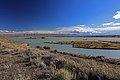
Settlement on the Mathrali steppe.

Mathrali Steppe panoramic view.

View of the eastern Mbatswani mountains.

Vweqwoto (Southern Port), surrounded by the Mbatswani mountains.

The national flower, a Rifałis, as is on the flag.

The Southern Vjesqo Mountain range, as seen from the sea.
Northern end of Lake Mvanye, the Mvanye river.

The Bałama Volcano Lake.

Landscape surrounding Súeboçó.
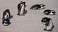
Penguins near Boçó.

Part of the Mvanye river delta.
.JPG)


.jpg)


.jpg)
.jpg)
Government & Politics
Government Structure
The structure of the Mathrali government is a unique one, with it being described as unicameral, bicameral, and unicameral by various scholars, though it consists of the following:
- House of Chiefs: This is an advisory body to the People's Chamber, aka Parliament, wherein 8 members are hereditary chiefs (who may not belong to any political party), 20 members are elected by various tribal councils, 2 members represent the mainland and island-swelling Ziromnian settlers, and the remaining 5 members are appointed by the president. This totals to 35 members, who's powers are almost purely advisory. All bills affecting tribal organization, property, customary law, and the administration of customary courts go through the house before being discussed by the Parliament. The body must also be consulted when changes to the constitution or declarations of war are made. Lastly, the body has the power to summon members of the government to appear before it. There exists no term limits in the House of Chiefs.
- People's Chamber (Parliament): The Mathrali People's Chamber, aka the Mathrali Parliament, is composed of 85 members, 5 from each of the 19 regions split proportionately amongst the most voted for parties in said regions (typically requiring a party to get at least 20% of the vote). It has the traditional Speaker, Deputy Speaker, and a Leader of the Opposition. If desired, two-thirds of the members can vote to recall a Speaker. In general, the main purpose of the parliament is to debate and pass bills. Typically, the president introduces a bill to the parliament before they examine it, renegotiate, debate, then send it to the House of Chiefs for approval before they can finally vote on it and send it back to the president (with a simple majority) who can veto or pass it into law. The parliament can also check the president's emergency powers (as they must approve of the emergency regulations) and elect the president to act as the head of state and the nominal head of government (where he can appoint cabinet members and summon and dissolve the parliament and/or propose legislation). Each member is allotted 4 5-year terms.
- Chamber of Censors: The Chamber of Censors are a group who would act as a check against the powers of the other two chambers. They are described as "prosecuting attorneys against the government in defense of the Constitution and popular rights". Their responsibilities are that they should ensure that the executive was functioning satisfactorily, having the powers of impeachment to ensure that. They can also actively audit other government bodies, approve court justices, and commissioners of the civil service. They are composed of 38 members, 2 elected from each province, with no term limits.
Political Parties
| Party Name | Ideology | Position | Seats in Parliament | Members |
|---|---|---|---|---|
| Abē Ebotho New Democracy |
Social Democracy Left-wing populism |
Center-left | 32 / 85 |
~33,500 |
| Vāthi ya Batho People's Party |
Democratic Socialism | Center-Left to left-wing |
11 / 85 |
~12,500 |
| Vāthi Tatła Green Party |
Environmentalism Democratic Socialism |
left-wing | 5 / 85 |
~7,500 |
| BoEbotho Tłofiso National Democratic Movement |
National Democracy National Conservativism |
right-wing | 20 / 85 |
~28,000 |
| Vāthi Bomathrali Mathrali National Party |
Nationalism Right-wing populism |
far-right | 8 / 85 |
~6,000 |
| Lesēko Libertarians |
Classical Liberalism | Center-right to right-wing |
3 / 85 |
~2,500 |
| Vāthi Bokomonisi (B) Communist Party (Pranavist) |
Communism Pranavism |
far-left | 4 / 85 |
~3,000 |
| Vāthi Bokomonisi Communist Party |
Communism | far-left | 2 / 85 |
~2,000 |
Administrative Regions

There exist 19 regions in the nation of Mathral, each holding approximately 480,000 people. This division allows for fairly equal representation, and regional borders are redrawn quite often, especially in rural areas.
The regions are as follows:
1. Bochō City, the capital city and most densely populated district.
2. Swebochō, "North Bocho", second most densely populated
3. Sweqwoto, or "Northern Port"
4. Bochōrēn, or "outer/away from Bocho"
5. Atłun, third most densely populated city.
6. Atłunēn, "outer Atlu"
7. Dwatera, "Wide Earth"
8. Benīn City, fourth most densely populated.
9. Benīnēn, "Outer Benin"
10. Dugařa
11. Vwedwatera
12. Akwella, "river"
13. Swembatswa, "Northern Mbatswa"
14. Mbatswa, one of the most mountainous regions in the country, home to the dormant Mambwa volcano and nomadic "Sanna" ethnic group.
15. Vweqwoto, the "Southern Port" is home to a large population of historical Ziromnian settlers.
16. Daggwetha
17. Qatsī
18. Bathelyin, or "Near Bathel[onat]", it is a contested region as about half of those inhabiting it are ethnically Bathelonatian.
19. Bohwa Islands, a subtropical environment, they were integrated in and are inhabited primarily by Ziromnian settlers who occasionally advocate independence from the rest of Mathral. The southernmost island in this region, Tachinya Island, is disputed with Bathelonat.
Policies & Constitution
Officially, the government of Mathral practices a policy of armed neutrality, wherein it maintains an active military force, conscription (for males only), and has a relatively well-developed arms industry.
The country also practices a policy of multiracialism, with their existing 8 primary tribal governments and the Ziromnian settler-colonial population. While the indigenous and tribal peoples are allotted a majority of the political power (as they make up around 3/4ths of the population), Ziromnian political and regionalist representation is encouraged by government policy.
Military
The military has long been a source of contention, and though no military coup has ever actually occurred, many attempted coups have been foiled, especially in the 1970s and 1980s during the period of unification.
The Mathrali Defense Forces have since defended the nation without issue, with the police being a Gendarmerie, or a part of the military, specifically as part of the army. They are largely made up of soldiers recruited into the gendarmerie after completing the mandatory 1 year of conscription. This has also posed a serious political issue, as some groups on the left have advocated that the police be separated from the military.
Infrastructure
Economy
Demographics
Culture & Society
See Also