Regions of Caldia: Difference between revisions
Jump to navigation
Jump to search
m (Glitter moved page Regions of Glytter to Regions of Caldia) |
mNo edit summary |
||
| Line 11: | Line 11: | ||
**[[Aerach]] | **[[Aerach]] | ||
**[[Clane]] | **[[Clane]] | ||
*'''[[Central Caldia]]''' (''Lárnach | *'''[[Central Caldia]]''' (''Lárnach Glítteann'') | ||
**[[Liscannor]] | **[[Liscannor]] | ||
**[[Longford]] | **[[Longford]] | ||
Revision as of 23:30, 10 December 2019

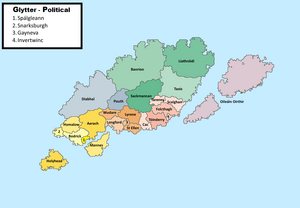
A geopolitical map of Caldia, exhibiting its 26 first-order subnational divisions (contaetha or "counties"). Each of the country's regions is uniquely coloured.
Caldia is commonly divided into six major geographical regions. These regions are purely geographical, and have no administrative purpose. According to most definitions, the contaetha are divided into the following regions:
- Southern Caldia (Deisceart na Ghlítteann)
- Central Caldia (Lárnach Glítteann)
- Lowlands (Isealchríocha)
- Highlands (Tailtarda)
- Oileáin Oirthir
- Sudreadharr