Tayar: Difference between revisions
No edit summary |
No edit summary |
||
| Line 79: | Line 79: | ||
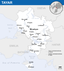
'''Tayar''' ({{wp|Help:IPA/English|/təˌjɑː(ɹ)/}}; [[Tayari language|Tayari]]: ''Tayâr'' {{wp|IPA|[tɑˈjɑːr]}}), officially the '''Tayari Republic''' ([[Tayari language|Tayari]]: ''Gomhûrî Tayârê'' {{wp|Help:IPA/English|[gɔmhuːriː tɑˈjɑːrɛː]}}), is a {{wp|country}} in X, at the crossroads of Pomria and X. Located in X, it is bounded by [[Oseva]] to the north, the Larija Gulf to the west, [[Similia]] to the south-west, the Sarvan Gulf to the south, and [[Hafar]] to the east. Tayar is a unitary {{wp|nation-state}} and multi-party democracy with an ancient cultural and historical heritage. It has a {{wp|population}} of around 9.4 million as of 2017 and an area of 37,749 km<sup>2</sup> (14,575 sq mi), though its territorial integrity has only [[Tayar#Territorial disputes|partial recognition]]. Its capital and largest city is Lazhyan. | '''Tayar''' ({{wp|Help:IPA/English|/təˌjɑː(ɹ)/}}; [[Tayari language|Tayari]]: ''Tayâr'' {{wp|IPA|[tɑˈjɑːr]}}), officially the '''Tayari Republic''' ([[Tayari language|Tayari]]: ''Gomhûrî Tayârê'' {{wp|Help:IPA/English|[gɔmhuːriː tɑˈjɑːrɛː]}}), is a {{wp|country}} in X, at the crossroads of Pomria and X. Located in X, it is bounded by [[Oseva]] to the north, the Larija Gulf to the west, [[Similia]] to the south-west, the Sarvan Gulf to the south, and [[Hafar]] to the east. Tayar is a unitary {{wp|nation-state}} and multi-party democracy with an ancient cultural and historical heritage. It has a {{wp|population}} of around 9.4 million as of 2017 and an area of 37,749 km<sup>2</sup> (14,575 sq mi), though its territorial integrity has only [[Tayar#Territorial disputes|partial recognition]]. Its capital and largest city is Lazhyan. | ||
Tayar is a {{wp|Unitary state|unitary}} {{wp|semi-presidential system|semi-presidential}} {{wp|republic}} as definded by its [[Tayar#Government and politics|constitution]] with a {{wp|parliamentary system}}, {{wp|proportional representation}}, and {{wp|universal suffrage}} since 1940. The [[Tayar#Government and politics|President]] serves as {{wp|head of state}} and ''de facto'' leader of the country, though only {{wp|ceremonial heads of state|ceremonial}}, while in reality the [[Tayar#Government and politics|Minister-General]] oversees political affairs as {{wp|head of government}}. The [[Tayar#Government and politics|National Council]] is the country's {{wp|unicameral}} {{wp|legislature}}. Tayar maintains diplomatic relations with two-thirds of the world's countries and holds membership in a number of international organizations, including the [[Assembly of Nations]] (since 1967), X. It has a high level of human development as indicated by the {{wp|Human Development Index}}. It has a reasonable rate of {{wp|economic development}}, as it is the [[List of Gaian countries by GDP|16th or 17th-largest economy]] in the world, {{wp|literacy}}, {{wp|women's safety}},{{wp|employment}}, and ranks among the world's top nations by percentage of citizens with military training. However, the government has been critized for its treatment and harrasment of ethnic [[Similia|Similian]] in disputed territories. | Tayar is a {{wp|Unitary state|unitary}} {{wp|semi-presidential system|semi-presidential}} {{wp|republic}} as definded by its [[Tayar#Government and politics|constitution]] with a {{wp|parliamentary system}}, {{wp|proportional representation}}, and {{wp|universal suffrage}} since 1940. The [[Tayar#Government and politics|President]] serves as {{wp|head of state}} and ''de facto'' leader of the country, though only {{wp|ceremonial heads of state|ceremonial}}, while in reality the [[Tayar#Government and politics|Minister-General]] oversees political affairs as {{wp|head of government}}. The [[Tayar#Government and politics|National Council]] is the country's {{wp|unicameral}} {{wp|legislature}}. Tayar maintains diplomatic relations with two-thirds of the world's countries and holds membership in a number of international organizations, including the [[Assembly of Nations]] (since 1967), X. It has a high level of human development as indicated by the {{wp|Human Development Index}}. It has a reasonable rate of {{wp|economic development}}, as it is the [[List of Gaian countries by GDP|16th or 17th-largest economy]] in the world, high rate of {{wp|literacy}}, {{wp|women's safety}}, {{wp|employment}}, and ranks among the world's top nations by percentage of citizens with military training. However, the government has been critized for its treatment and harrasment of ethnic [[Similia|Similian]] in disputed territories. | ||
==Etymology== | ==Etymology== | ||
Revision as of 19:37, 10 February 2020
This article is incomplete because it is pending further input from participants, or it is a work-in-progress by one author. Please comment on this article's talk page to share your input, comments and questions. Note: To contribute to this article, you may need to seek help from the author(s) of this page. |
Tayari Republic Gomhûrî Tayârê (Tayari) | |
|---|---|
| Motto: "X" "For Our People" | |
| Anthem: "X" "Banner of the Fatherland" | |
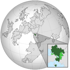
 Location of Tayar (green) with Similian and foreign Tayari controlled territories (light green) | |
 19XX border (internationally recognized) | |
| Capital and largest city | Lazhyan |
| Official languages | Tayari |
| Recognised regional languages | Lavish, Osevan |
| Ethnic groups | X |
| Religion | X |
| Demonym(s) | Tayari |
| Government | Unitary semi-presidential republic |
• President | Mahmoud Wezwar |
• Minister-General | Bushar Aboun |
• Speaker of Parliament | Salim Leuge |
| Legislature | National Council |
| Formation | |
• X | X |
• X | X |
• X | X |
• X | X |
• X | X |
• X | X |
• X | X |
| Area | |
• Total | 37,749 km2 (14,575 sq mi) |
• Water (%) | 4.8% |
| Population | |
• 2018 estimate | 9,735,800 |
• 2017 census | 9,416,393 |
| GDP (PPP) | 2019 estimate |
• Total | $165.4 billion (16th) |
• Per capita | $16,992 |
| GDP (nominal) | 2018 estimate |
• Total | $71.6 billion (17th) |
• Per capita | $7,350 |
| HDI (2017) | 0.753 high |
| Currency | Herai (२) (HR) |
| Time zone | UTC+4 |
| Date format | MM/DD/YYYY |
| Driving side | right |
| Calling code | +838 |
| Internet TLD | .ty |
Tayar (/təˌjɑː(ɹ)/; Tayari: Tayâr [tɑˈjɑːr]), officially the Tayari Republic (Tayari: Gomhûrî Tayârê [gɔmhuːriː tɑˈjɑːrɛː]), is a country in X, at the crossroads of Pomria and X. Located in X, it is bounded by Oseva to the north, the Larija Gulf to the west, Similia to the south-west, the Sarvan Gulf to the south, and Hafar to the east. Tayar is a unitary nation-state and multi-party democracy with an ancient cultural and historical heritage. It has a population of around 9.4 million as of 2017 and an area of 37,749 km2 (14,575 sq mi), though its territorial integrity has only partial recognition. Its capital and largest city is Lazhyan.
Tayar is a unitary semi-presidential republic as definded by its constitution with a parliamentary system, proportional representation, and universal suffrage since 1940. The President serves as head of state and de facto leader of the country, though only ceremonial, while in reality the Minister-General oversees political affairs as head of government. The National Council is the country's unicameral legislature. Tayar maintains diplomatic relations with two-thirds of the world's countries and holds membership in a number of international organizations, including the Assembly of Nations (since 1967), X. It has a high level of human development as indicated by the Human Development Index. It has a reasonable rate of economic development, as it is the 16th or 17th-largest economy in the world, high rate of literacy, women's safety, employment, and ranks among the world's top nations by percentage of citizens with military training. However, the government has been critized for its treatment and harrasment of ethnic Similian in disputed territories.

