Holy Gothic Empire: Difference between revisions
Jump to navigation
Jump to search
Lyooonheimer (talk | contribs) No edit summary |
Lyooonheimer (talk | contribs) No edit summary |
||
| Line 74: | Line 74: | ||
|symbol_type = <!-- Displayed text for link under symbol. Default "Coat of arms" --> | |symbol_type = <!-- Displayed text for link under symbol. Default "Coat of arms" --> | ||
|symbol_type_article = <!-- Link target under symbol image. Default: Coat of arms of {{{common_name}}} --> | |symbol_type_article = <!-- Link target under symbol image. Default: Coat of arms of {{{common_name}}} --> | ||
|image_map = | |image_map = [[File:Screenshot 2021-08-14 193233.png|200px]] | ||
|image_map_alt = | |image_map_alt = | ||
|image_map_caption = | |image_map_caption = The height of the Holy Gothic Empire (1567) in comparison with modern borders | ||
|image_map2 = <!-- If second map is needed; does not appear by default --> | |image_map2 = <!-- If second map is needed; does not appear by default --> | ||
|image_map2_alt = | |image_map2_alt = | ||
Revision as of 13:35, 28 August 2021
Holy Gothic Empire Szent Gót Birodalom (Hungarian)) Heilaofa Gotheskur Stórecht (Götaish) Heiliges Gotisches Rijch (Middle Alemanic) | |||||||||
|---|---|---|---|---|---|---|---|---|---|
|
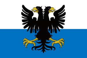
Flag | |||||||||
 The height of the Holy Gothic Empire (1567) in comparison with modern borders | |||||||||
| Status | Former Territories | ||||||||
| Religion | Catholic Church (970-1723) Protestant (1519-1723) | ||||||||
| Government | Confederal elective monarchy | ||||||||
| Historical era | 970-1723 | ||||||||
| |||||||||
| Today part of | |||||||||
The Holy Gothic Empire is a former multi-ethnic territory in southern Thrismari.
