Ceris: Difference between revisions
Jump to navigation
Jump to search
mNo edit summary |
mNo edit summary |
||
| Line 1: | Line 1: | ||
{{Infobox islands | |||
| name = Ceris | |||
| native_name = <!-- or |local_name= --> | |||
| native_name_link = | |||
| native_name_lang = | |||
| sobriquet = <!-- or |nickname= --> | |||
| image_name = Map of Ceris.png | |||
| image_size = 200px | |||
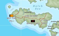
| image_caption = Map of Ceris | |||
| image_alt = Map of Ceris | |||
| image_map = | |||
| image_map_alt = | |||
| image_map_size = | |||
| image_map_caption = | |||
| pushpin_map = | |||
| pushpin_label = | |||
| pushpin_label_position = | |||
| pushpin_map_alt = | |||
| pushpin_relief = | |||
| pushpin_map_caption = | |||
| coordinates = <!-- {{coord|display=it}} --> | |||
| etymology = | |||
| location = [[Adlantic Ocean]]<!-- mandatory, body of water where located --> | |||
| grid_reference = <!-- UK only --> | |||
| archipelago = | |||
| waterbody = | |||
| total_islands = | |||
| major_islands = | |||
| area_km2 = <!-- or |area_m2= or |area_ha= --> | |||
| area_footnotes = | |||
| rank = | |||
| length_km = <!-- or |length_m= --> | |||
| length_footnotes = | |||
| width_km = <!-- or |width_m= --> | |||
| width_footnotes = | |||
| coastline_km = <!-- or |coastline_m= --> | |||
| coastline_footnotes = | |||
| elevation_m = | |||
| elevation_footnotes = | |||
| highest_mount = | |||
| country = <!-- mandatory --> | |||
| country_admin_divisions_title = | |||
| country_admin_divisions = | |||
| country_admin_divisions_title_1 = | |||
| country_admin_divisions_1 = | |||
| country_admin_divisions_title_2 = | |||
| country_admin_divisions_2 = | |||
| country_capital_type = | |||
| country_capital = | |||
| country_largest_city_type = | |||
| country_largest_city = | |||
| country_capital_and_largest_city = | |||
| country_largest_city_population = | |||
| country_leader_title = | |||
| country_leader_name = | |||
| country_area_km2 = <!-- or |country_area_m2= or |country_area_ha= --> | |||
| country1 = | |||
| country1_admin_divisions_title = | |||
| country1_admin_divisions = | |||
| country1_admin_divisions_title_1 = | |||
| country1_admin_divisions_1 = | |||
| country1_capital_type = | |||
| country1_capital = | |||
| country1_largest_city_type = | |||
| country1_largest_city = | |||
| country1_capital_and_largest_city = | |||
| country1_largest_city_population = | |||
| country1_leader_title = | |||
| country1_leader_name = | |||
| country1_area_km2 = <!-- or |country1_area_m2= or |country1_area_ha= --> | |||
| demonym = | |||
| population = | |||
| population_as_of = | |||
| population_footnotes = | |||
| population_rank = | |||
| population_rank_max = | |||
| density_km2 = | |||
| density_rank = | |||
| density_footnotes = | |||
| languages = Anglish | |||
| ethnic_groups = | |||
| timezone1 = | |||
| utc_offset1 = | |||
| timezone1_DST = | |||
| utc_offset1_DST = | |||
| website = | |||
| additional_info = | |||
| footnotes = | |||
}} | |||
{{wip}} | {{wip}} | ||
'''Ceris''' is an island located in the [[Adlantic Ocean]]. It is bordered by the [[Dolch Sea]] and [[Argis]] to the north, the [[Qingming Sea]] to the west, and [[Seylos]] to the east. | '''Ceris''' is an island located in the [[Adlantic Ocean]]. It is bordered by the [[Dolch Sea]] and [[Argis]] to the north, the [[Qingming Sea]] to the west, and [[Seylos]] to the east. | ||
Revision as of 16:01, 2 September 2021
 Map of Ceris | |
| Geography | |
|---|---|
| Location | Adlantic Ocean |
| Demographics | |
| Languages | Anglish |
This article is incomplete because it is pending further input from participants, or it is a work-in-progress by one author. Please comment on this article's talk page to share your input, comments and questions. Note: To contribute to this article, you may need to seek help from the author(s) of this page. |
Ceris is an island located in the Adlantic Ocean. It is bordered by the Dolch Sea and Argis to the north, the Qingming Sea to the west, and Seylos to the east.